CapeCodHistory.us home page

scanned from the volume at the Marine Biological Laboratory Library, Woods Hole
posted Oct 2005

A Report upon the Alewife Fisheries of Massachusetts
David L. Belding. Boston: Commonwealth of Massachusetts, Department of Conservation, Divsion of Fisheries and Game. 1920

Introduction
Natural History
The Fishery
History and Legislation
Causes of Decline
Remedial Measures
Survey of Herring Rivers, Ponds, Streams
Bibliography
Index


The Commonwealth of Massachusetts

A REPORT

UPON THE

ALEWIFE FISHERIES OF MASSACHUSETTS

Division of Fisheries and Game Department of Conservation

Mass-MBL


publication of this Document Approved by Alfred C. Holland, State Purchasing Agent.
1M-64 — 938500                                                                         Estimated Cost per Copy $.610


Publication of this Document approved by the Supervisor of Administration.

The Commonwealth of Massachusetts

William C. Adams, Director, Division of Fisheries and Game, State House,

Boston, Mass.

Sir: — I herewith submit a report upon the history, present condition and possibility of development of the alewife fishery of Massachusetts. This investigation was made in 1912, 1913, 1917, 1919 and 1920 under the provisions of chapter 178, Acts of 1902. The survey of 1912 and 1913 was done by Mr. Roy S. Corwin, at that time Assistant Biologist.

Respectfully submitted,

DAVID L. BELDING,

Biologist.


REPORT UPON THE ALEWIFE FISHERIES OF MASSACHUSETTS.

Part I.

INTRODUCTION.

An important part of the work of a progressive State fish and game commission is the investigation of natural resources for the purpose of determining proper and effective methods of conserving these valuable assets for the benefit of the public. For the past fifteen years the Massachusetts Division of Fisheries and Game has been investigating such economic problems, one of which, the alewife fishery, furnishes an excellent illustration of the practical value of biological study in the preservation of a commercial fishery.

Importance.—Since the disappearance of the shad, the ale-wife, or branch herring {Pomolobus pseudoharengus), the most abundant food fish inhabiting the rivers of the Atlantic coast, has become commercially the most valuable anadromous fish in Massachusetts. Ever since the landing of the Pilgrims, when the alewife provided the most readily available source of food for the early inhabitants of New England, it has been closely related to the prosperity of the shore towns, where it has always been held as a public asset. The successful re-establishment of this depleted fishery would benefit the shore towns directly, and indirectly would prove of even greater value to the fisheries as a whole.

The alewife is of value as food, as bait, and as a food supply for other salt and fresh-water fish. Either fresh or cured, it forms an excellent and inexpensive article of diet. Because of its abundance and comparative cheapness, it is satisfactory as bait, and recently its scales have become of commercial value. In the fresh-water ponds, which serve as spawning grounds, the young alewives furnish a by no means insignifi-

6

cant source of food for the predacious fresh-water species such as bass, perch and pickerel. Of greater importance is the attraction they offer to pollock, bluefish, squeteague and other marine food fishes which come to our shores to prey upon the young alewives when they descend the coastal streams. The simultaneous decline of the alewife and shore fisheries suggests that there is a direct relation between the two, and that the success of the fishing towns along the coast in a considerable measure is dependent upon the flourishing condition of the alewife fishery.

Results. — The investigation has shown the present impoverished condition of the fishery, the causes contributing to its decline, and has brought out certain points in the life history and habits of the alewife which furnish a basis for establishing cultural methods. These remedial measures are based upon a thorough and judicious consideration of the facts disclosed by a study of the natural history of the alewife, a survey of the streams up which alewives once ran, and a review of the statistical records of each fishery. If this program is followed and the present faulty methods of operating the fishery are eliminated, the alewife industry of Massachusetts is capable of substantial development.

The requisite steps in the reconstruction work are: —

(1)  An unobstructed and uncontaminated passageway from salt water to the spawning grounds.

(2)  Artificial restocking of depleted streams and the creation of new fisheries in favorable localities.

(3)  Adequate and efficient methods of regulating the fishery.

Presentation. — The aim of this report is to present to the general public, more especially the residents of the shore towns, general information concerning the present condition, history and possibility of development of the alewife fishery. Harmful practices of various kinds have been uncovered, and responsibility for these conditions has been squarely and openly placed where it belongs.

The first part of the report considers general topics, such as: (1) The natural history; (2) the fishery; (3) the causes of decline; and (4) remedial measures. The second part contains a description of the individual alewife streams, arranged in geographical order, with specific recommendations for their

7

development. The length of this report does not permit the publication of many interesting details concerning the various fisheries, complete records of which are on file with the Division of Fisheries and Game.

Acknowledgments. — The greater part of the statistical and survey work was conducted in a most capable manner by Mr. Roy S. Corwin, to whom special commendation is due for his excellent and accurate descriptions of the numerous streams and fisheries. The observations on the spawning and artificial propagation of the alewife were made in 1919 and 1920 by Mr. J. A. Kitson. Our sincere thanks are due to the many holders of the alewife privileges, both past and present, and to alewife dealers, for their ready co-operation, with few exceptions, in furnishing reliable information as to the yield, methods of operation and history of the fisheries. We are also deeply indebted to town officials, particularly to town clerks and members of herring committees, for their courtesy in furnishing valuable records.

Methods of Investigation. — The work consisted of three parts: (1) a survey of the coastal streams; (2) a statistical study of fishing methods; and (3) an investigation of the life-history and habits of the alewife.

The survey comprised a biological examination and personal inspection of each stream, with maps and descriptions of all important features. Special emphasis was placed on the condition and accessibility of the spawning grounds, the location of dams, presence or absence of fishways, the volume of water in the stream, and possible sources of pollution, both trade waste and sewage. The life history and habits were observed at the spring runs, on the spawning grounds and during artificial' hatching.

The various methods of operating the fishery under town control were studied from the standpoint of efficiency and the resulting effect upon general conditions in the different streams. The testimony of members of herring committees, operators of fisheries, fish dealers and townspeople interested in the fisheries, was taken, and the town records were examined for local regulations. Statistics, both past and present, were gathered from all available sources, including town documents, fish committee reports and various legislative enactments.

8

NATURAL HISTORY.

Species. — The herrings, Clupeidœ, are characterized by an oblong body, absence of the lateral line, and by cycloid scales. While the majority of the numerous herring species are confined to the ocean, some ascend the coastal rivers for the purpose of spawning. In the latter class is the alewife {Pomolobus pseudoharengus), which is reported by Bean (1) as landlocked in the lakes of New York. In Massachusetts waters the principal allied species capable of being confused with the alewife are the adult and young of both the sea herring (Clupea harengus) and the glut herring (Pomolobus ζstivalis), and the young menhaden (Brevoortia tyrranus).

Names. — The scientific name of the alewife is Pomolobus pseudoharengus (Wilson), although the term Clupea venialis was used by McDonald in 1880, and Alosa tyrranus and Clupea tyrranus by Lyman in 1872. The common names of this species are branch herring; spring herring; alewife in New England, with the modifications of ellwife or ellwhop on the Connecticut River; big-eyed or wall-eyed herring on the Albemarle River; grey back, to distinguish it from the blueback, blackback or glut herring; and gaspereau and kyack in Canada.

Description. — The alewife in general conforms closely to the herring type, but is characterized by a grayish blue back, white silvery sides, fairly deep body, strongly serrated abdomen and large eyes. In Massachusetts the adults range in size from 8.5 to 13 inches, the average being 10.58 inches. Three and four year old fish, and possibly even two, may ascend the same stream, causing marked variation in the different schools, as is indicated by the following measurements from ten streams: —


      Sex. Number. Length in Inches.
Smallest. Largest. Average.
Male,   634  8.50 12.00 10.29
Female,   636  9.50  13.00  10.88
      Total, 1,270 8.50 13.00 10.58


9

Although the difference in the size of fish at various periods of the spring run is a matter of comment among the fishermen, our measurements, confined to a limited period on Monument River, Bournedale, show only a slight difference.


Date.
Males. Females. Total.
Number. Length
 (Inches).
Number. Length
 (Inches).
Number. Length
 (Inches).
May 14, 1920, 43 10.71 57 10.92 100 10.83
May 20, 1920, 100 10.41 100 11.04 200 10.73

The variation in the different streams is somewhat more striking.


Length in Inches.

Stream.

Date

Males.

Females.

Greater
Length
of Females.

Mashpee River,

May 18, 1920

10.00

10.59

.59

Herring River, Harwich,

May 11, 1920

10.28

10.97

.69

Agawam River,

May 19, 1920

10.19

10.76

.57

Mattapoisett River,

May 19, 1920

10.51

11.03

.52

Red Brook, Cataumet,

May 18, 1920

9.89

10.70

.81

Monument River,

May 20, 1920

10.41

11.04

.63

The males are smaller and weigh less than the females, and during the breeding season the different contour of the females makes separation easy. In 1,270 measurements the males averaged 10.29 inches compared with 10.88 inches for the females, a difference of 0.59 of an inch in favor of the latter. Approximately 92 per cent of the fish ran as follows: males, from 9.5 to 11 inches; females, 10 to 11.5 inches.

There is some danger of confusion with the glut herring, which also enters the coastal streams for spawning, but at a slightly later date than the true alewife. According to Smith (4) its spawning takes place nearer the sea. Although superficially the alewife and glut herring resemble each other, the black lining of the body cavity in the latter makes differentiation easy. A close observer will note that externally the alewife is deeper,

10

has more elevated fins, larger eyes, and a lighter colored back than the glut herring.

Distribution. — The alewife is common along the Atlantic coast from Canada to North Carolina. In Massachusetts practically all the coastal streams were formerly frequented by this fish, but as a result of the activities of man, it has been exterminated in many localities.

Reproduction.

At the approach of the spawning season the alewife ascends the tidal streams in order to deposit its spawn in fresh water, a process which has become a part of the life cycle of anadromous fish, and for which no satisfactory explanation has ever been offered.

Sexes. — The ratio of males and females in the spring run varies considerably, first one sex and then the other predominating. On the spawning grounds the usual combination is 5 to 6 males to 1 female, although schools of 10 to 25 males may be seen following 1 or 2 females. Apparently the males greatly predominate in the late runs. On June 23, 1919, as high as 95 per cent males were obtained in Monument River, and 98 per cent on the spawning grounds of Great Herring Pond. Observations in May, 1920, gave the following proportion of males and females during the spring run: —


Stream.
Date.
Per Cent.
Males. Females.
Mashpee River, May 18 53.0 47.0
Herring River, Harwich, May 12 51.5  48.5
Agawam River, May 19 35.9 64.1
Monument River,
May 14
May 20
43.0
41.5
57.0
58.5
Mattapoisett River, May 17 44.5 55.5
Red Brook, Cataumet, May 18 56.0 44.0

Eggs. — The eggs, averaging 1/20 of an inch in diameter, when deposited sink to the bottom where they adhere to stones, gravel, coarse sand, logs and other material. This ad-

11

hesive quality, since it causes massing together, furnishes one of the difficulties of artificial hatching. Microscopically the eggs appear as dense opaque spheres filled with yolk granules. They approximate the size of white perch eggs, numbering from 60 to 100,000 per female. When collected for hatching, after adhesion and clumping have stopped, the eggs are firm, hard and of a light coffee color.

Spawning Habits. — The majority of females when running up stream contain unripe eggs, while the greater part of the males appear ripe.


Stream.


1920.
Males (Per Cent). Females (Per Cent).
Ripe. Partly
 Ripe.
Unripe. Ripe. Partly
 Ripe.
Unripe.
Mashpee River, May 18 100 -
-
2
94
4
Herring River, Harwich, May 11 91 7
2
6
46
48
Agawam River, May 26 92 5
3
6
82
12
Monument River, May 14
May 20
83
78
12
12
5
10
4
15
77
69
19
16
Mattapoisett River, May 19 93 5
2
15
79
6
Red Brook, Cataumet, May 18   97     3
    -
    7
    66
    27
      Average,
90.6 6.3
3.1
7.8
73.3
18.9

Temperature conditions being favorable, the eggs rapidly ripen when the fish reaches the spawning grounds. During the act of spawning the alewives swim in small schools around the edges of the pond, one female accompanied by several males. When the eggs are deposited they are immediately covered with the milt by the closely following males. During this schooling or mating process the fish dart hither and thither over the sandy shoals, frequently breaking the surface of the water by their energetic rushing. Apparently no distinction is made as to the time of depositing the spawn, which is accomplished both by day and night. Our observations suggest that the greater part is accomplished during the day, whereas Prince (5) finds that in Canada on moonlight nights the shallow waters present a much disturbed appearance, owing to the energetic movements of mating fish. After spawning, the alewives remain a variable time in the pond, and then return to salt water.

12

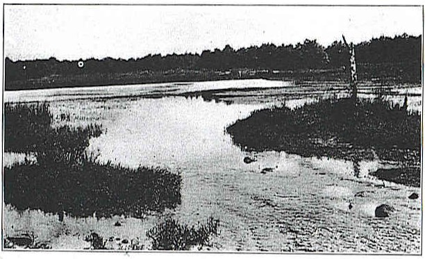
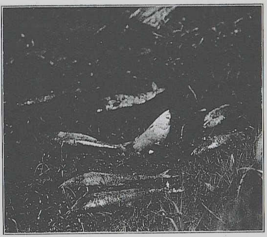
Spawning Grounds. — In Massachusetts the fresh-water ponds which form the headwaters of the coastal streams furnish the spawning grounds. Two classes are found: (1) the ordinary tributary tidal stream, with one or more fresh-water ponds at its source at a variable distance from the ocean, and (2) the fresh or brackish shore pond (Fig. 1) separated from the salt water by a narrow sand beach through which there is a shifting natural opening or an artificial channel. The ponds of Martha's Vineyard belong to the latter type, and the alewives enter directly from the salt water through temporary openings.

Spawning Season. — The spawning season varies slightly from year to year, the approach of the alewives to the shores being regulated chiefly by temperature. According to the United States Bureau of Fisheries, records the alewife is seen in the Potomac River by March 4, but in New Brunswick does not enter the St. John River until May 10, although present in the Bay of Fundy in April. The first fish appear earlier in certain streams. In Massachusetts the greater part of the run occurs between the middle of April and the first of June. In some streams the first fish come as early as the last week in March, and in others are still running by the last of June. In 1920 the run started as follows: March 20, Mattapoisett River; April 1, Agawam River, Herring River, Wellfleet, Bass River; April 10, Herring River, Harwich; April 15, Mashpee River; May 1, Monument River and Stony Brook, Brewster.

Temperature and Spawning. — Temperature is the most important factor in regulating the spawning season from the appearance of the adult alewives off the coast to the development of the young. A certain minimum is necessary to permit the spawning to take place, and above 55° F. the development of the egg becomes more rapid in direct proportion with the increase in temperature, until the maximum is attained — about 70° F. The 1920 temperature of Nye's Pond, a spring-fed body of water where alewives naturally spawn, is given in the following table. The first alewives came May 10, and were descending as late as August 20.

13


Week ending
Average
 Temperature
 of Water
(Degrees F.).


Week ending
Average
Temperature
of Water
(Degrees F.).
March 6, 36.8 May 22, 57.3
March 13, 38.0 May 29, 56.1
March 20, 43.0 June 6, 62.5
March 27, 49.5 June 13, 61.6
April 3, 49.6 June 20, 61.3
April 10, 46.9 June 27 64.4
April 17, 48.0 July 3, 67.2
April 24, 50.1 July 10, 67.4
May 1, 51.6 July 17, 67.6
May 8, 52.3 July 24, 68.3
May 15, 55.8 July 31, 66.4

Development. — When the eggs are deposited on the natural beds they are at once covered with milt, which the male scatters by thrashing his tail. The eggs then adhere to the suitable objects on the bottom in such a way that it is impossible to gather any appreciable quantity for hatching purposes. On "stripping" the fish for artificial fertilization the eggs adhere to each other and form masses until "hardened" by frequent washings.

The period of time which it takes artificially fertilized eggs to hatch at 72° F. ranges from forty-eight to ninety-six hours. The first lot of 8 ounces was placed at the Sandwich Hatchery June 25, 1919, and in forty-eight hours one-half had hatched, 80 per cent of the eggs proving fertile. In the surface water were thousands of tiny alewives with food sacs, nearly trans-

14

parent in appearance, and with tails resembling fine silk threads. The tiny creatures, about one-fifth of an inch in length (5 millimeters), wiggled through the water with surprising activity. The eyes in both the egg and the hatched fish were but faintly visible. At the end of ninety-six hours their size had increased considerably, the outline of the yolk sac and body was plainly marked, and the eyes showed prominently. By this time all the eggs had hatched. In cold water the period of development is retarded proportionately to the lowering of the temperature. As the eggs require such a short time for hatching, the young fry are soon present in abundance on the spawning grounds.

According to Prince (5) the young alewife reaches three-fifths of an inch (15 millimeters) at the end of the first month, when it becomes a slim, translucent creature with a broad tail and relatively large pre-anal fin, more closely resembling a sand eel than an alewife. Some ten days later, when measuring 16.5 millimeters, the young fish is more slender, the tail has become more spatulated, the dorsal fin is more prominent, and the head is short and blunt, with a relatively large eye. At the size of  l 1/5 inches (30 millimeters), the young alewife assumes more nearly the appearance of the adult, with a large rounded head, relatively large eye, and shortened body. When 1 2/5 inches (35 millimeters) long, the appearance is practically the same, with the exception of the lengthened translucent body and the appearance of the serrations of the middle abdominal scales, — a characteristic of the adult.

The young alewives attain the approximate length of 2 to 4 inches by fall, when they descend from the breeding grounds to the ocean, unless their journey is prevented by artificial obstructions. Young alewives have been seen as early as June 18 passing down stream to the ocean, but the majority do not start on the journey until the first of September, or later. At Cornelius Island, Rhode Island, Tracey (6) records specimens measuring 1 1/2 inches which were taken in a seine on Aug. 8, 1908. Bean (1) states that specimens taken in Great South Bay, Long Island, on this date, ranged from 2 to 3 7/8 inches, and in September, from 2 to 4 1/2 inches.

In late summer young alewives of various lengths school on

15

the spawning ponds, their size depending upon: (1) geographical location, spawning taking place earlier in southern waters; (2) time of spawning, eggs from the first run hatching almost two months earlier than those of the last; (3) temperature, abundance of food supply, size of spawning ponds, and length of time before the return to salt water. Their subsequent rate of growth is largely a matter of conjecture, since they are not seen again until they return as adult fish to the parent stream for spawning.

Food. — In salt water, the food of the alewife and other herring consists mostly of small plankton forms, such as diatoms, algζ, small crustaceans, and other minute animals and plants. Instances have been cited where alewives have risen to the artificial fly, and where they have been taken with small eels as bait; but, as a rule, in passing to the spawning grounds alewives take little or no food. The young feed on the freshwater plankton forms so abundant in the spawning ponds, and with increasing size enlarge the scope of their dietary.

Enemies.—Among the natural enemies which attack both young and adult are man, predacious fish, birds, disease, pollution and changes in environment. As soon as the eggs are deposited the uphill struggle for existence begins. Following the spawning alewives come a procession of white and yellow perch, suckers and minnows, eagerly devouring the ripe spawn, — a procedure which occurs in every pond inhabited by these species. Individually, suckers appear the most destructive, yellow perch next and white perch the least.

As the young alewives increase in size they serve as food for the larger fresh-water fishes such as perch, bass and pickerel, and when they descend to the ocean their arrival is often anticipated by numerous salt-water species which lie in wait at the mouths of the coastal rivers. In the fall of 1915, in Agawam River, a school of white perch was observed eagerly feeding upon young alewives as they descended the stream. The loss from birds such as herons, terns and other fish-eating species is an indeterminable but probably a negligible factor.

Both the young and old fish are susceptible to bacterial and parasitic diseases, concerning which little is known at the present time. The older fish have a lowered vitality after spawn-

16

ing, and in their weakened condition are less able to withstand attacks of fungus and similar fresh-water affections.

In the ponds both young and old alewives are subjected to changes in food supply, oxygen content of the water, temperature and weather conditions. The artificial changes in the rivers, streams and ponds resulting from the influence of trade waste pollution plays an appreciable but as yet indeterminable part in their life history and habits.

Migration.

Little is known of the history of the alewife after it descends as a small fish to the ocean. Exactly where it goes and what happens in the interval before its return is unknown, although it probably frequents deep water. Even the extensive studies of the habits and migrations of the sea herring, especially on the Scottish coast and in the North Sea, have thrown little light on this phase of the existence of the closely related alewife.

The fresh-water cycle of the alewife's life is better known. It approaches the coast at a definite period in the spring, making its appearance in the vicinity of the Carolinas as early as March, and later reaching the northern rivers. This sequence does not prove a definite northward movement, but it indicates that its annual migration is largely governed by the temperature of the water.

After spawning the adult fish returns to salt water in a lean, emaciated condition. Whether these fish spawn but once or continue to spawn annually has not been determined. The experience of commercial observers indicates that they probably spawn but once. If the same fish spawned repeatedly the fishery would enlarge beyond our most favorable dreams, and fluctuations in the annual catch would not exist.

Ascending Streams. — Current appears to be the stimulating factor in the ascent of streams. In a rapid flow, progress is almost continuous, but in more quiet waters, such as pools or eddies, for no apparent reason, the fish may remain in one locality, darting forward, falling back, shifting position, or lying quietly in the stream, but making no appreciable headway. Then one fish, usually a female, takes the lead, closely followed by several males, the entire school trailing along behind, and

17

the process is repeated in another place. If the water forms an eddy, the alewives swim in circles, apparently unable to differentiate the back flow from that of the main stream, up which they may show a reluctance to ascend.

Alewives ascend in schools of five to ten, unless the run is especially heavy, when a steady procession is formed. In ascending falls some time is usually spent in maneuvering for the start. A quick dart forward directly into the current, with a wriggling movement, shoots the fish rapidly along until the first obstacle is reached, when it leaps into the air, returning to the water once more for another short dash and a second rise, if further obstructions are present. Thus, in passing a series of abrupt rises in a natural stream, or in a straight-run fishway, the alewife by a quick, powerful start makes a series of rapid flights alternately through the air and water until it reaches the calm water at the top. Many are unsuccessful, and are swept downstream, where they begin the ascent once more. In such locations a heavy run is a beautiful sight, with the silvery white of the leaping fish projected against the darker background of the stream.

The exact height over which an alewife can leap is not known, but it is probably in the neighborhood of 2 to 2 1/2 feet. The 1-foot rise used in our standard fishways is readily and easily taken by the adults. The facilities afforded for a run, strength of current and volume of flow determine the height which may be surmounted.

Exactly how much aid in passing over obstacles is furnished by the serrated ventral scales is problematical. The fish frequently turn slightly on one side and wriggle over obstacles, especially in shallow water, clinging and even progressing against tremendous odds.

Descending Streams. — When leaving the spawning grounds the adult fish pass through an interesting procedure. One school of fifty fish was observed to swim in circles, gradually approaching the opening to the stream. Suddenly, for no apparent reason, they darted back into the deeper waters of the pond, and, after repeating the advancing process, approached a little nearer to the outlet. Again they made a sudden retreat and a still nearer approach, and finally, after innumerable ap-

18

proaches and retreats covering a period of many hours, one fish, more bold than the rest, dared to enter the outlet, and after it trailed the entire school. Several days are consumed in passing down stream, the exact period of time depending upon the length of the river.

Parent Stream Theory. — From observations in handling local alewife fisheries the "parent stream theory" has been evolved. Briefly, the theory is that the young alewives descending from a particular pond and stream return as adult fish to the same stream for spawning, thus establishing a continuous chain. There are good reasons to consider this theory favorably. Practical demonstration has shown that fisheries have been created in streams which had no alewives by the simple expedient of placing spawning alewives in the headwaters. The offspring returned as adult fish to the same spawning grounds, thus establishing a fishery. Similarly, depleted fisheries have been re-established. Experience has likewise shown that a poor year, when but few alewives reach the spawning grounds, is followed at a stated interval by a corresponding lean year. From such observations we can accept the "parent stream theory" as the best working hypothesis available.

Among the specific illustrations of the return of alewives to the parent stream may be mentioned the following: —

(1)  According to the United States Bureau of Fisheries, several hundred spawning alewives were placed in Keene's Pond which had an outlet into Calais River, Maine. The young were noted in large numbers in the pond, and on the fourth year large numbers of adult fish returned for spawning to the Keene's Pond stream, where no alewives had even been seen before.

(2)  Lyman (3) reports the establishment of a fishery in four years in a similar manner at Plymouth.

(3)  Mr. George M. Besse of Wareham obtained results in three years in Little Mill Pond and in Five Mile Pond, and a remarkable increase in the fishery was obtained in Mattapoisett River in 1920 by allowing all fish to reach the spawning grounds in 1917.

This theory has been accepted as the basis of our future work in the development of the alewife fishery, and we can confi-

19

dently state that any stream with available spawning grounds may be given a commercial fishery by removing all obstructions to the free passage of alewives, and by placing a sufficient number of mature fish in the headwaters.

Influence of Natural Conditions. — The life history and habits of the alewife are markedly influenced by environment, especially during migration and spawning. Wind and tide affect their entrance and progress up streams, by shifting the sandy openings to the brackish water ponds near the coast, and changing the mouths of the streams. As a rule, alewives follow the greatest flow, — an important fact to take into consideration in the location of fishways.

Judging from the fact that fresh water evidently attracts anadromous fish in the spawning season, apparently the mineral content of the water has an important influence upon the migration of fish. If such is the case, chemical pollution from manufacturing plants may be a more serious problem than is commonly considered. Alewives ordinarily show a tendency to avoid the dark, but on the Agawam River they pass for 50 feet through an unlighted fishway. However, it is advisable whenever possible to have open fishways. Temperature and food supply also are important factors governing the movements of old and young.

THE FISHERY.

Commercially the alewife is valuable both for food and for bait. Its abundance and comparative cheapness renders it of the utmost importance to the Massachusetts shore towns. Smith (4) states that in 1896 nearly 150,000,000 were sold in fourteen States, in addition to large quantities given away at the shore, and that over 2,500 persons were engaged in the alewife fisheries, besides many thousands of people who operated apparatus in which alewives constituted an important part of the catch. At that time Maryland, North Carolina and Virginia were the leading alewife States, although important fisheries also existed in Maine, Rhode Island, Connecticut, Massachusetts, New York and New Jersey.

In Massachusetts there are two types of alewife fisheries, the natural and the artificial, both of which have been developed under town control.

20

Natural Fisheries.

In early days nearly every coast town possessed one or more natural streams upon which fisheries were soon established under town management, and in a few cases by private individuals. Unless the fishery was completely ruined, its operation was conducted in one or a combination of four ways: (1) free; (2) town-operated; (3) leased; and (4) privately owned.

Free. — The free alewife fisheries are the poorest producers, in some cases because the fishery is valueless, in others because the fishery is free. As the name implies, it gives any inhabitant of the town the privilege of catching alewives subject only to general regulations in regard to time, manner and place of capture. In most cases these regulations either do not exist or are not enforced. Usually the town is completely indifferent to the welfare of the fishery, and in maintaining it, follows the lines of least resistance.

Town-operated. — In a few cases the fishery is operated directly by the town, and the upkeep of the stream as well as the cost of catching is carried by the town as a straight business venture. Our observations indicate that this method has given uniformly poor results because of the inability of the town officials to run a commercial fishery as economically as a private business.

Leased. — Most fisheries are leased, i.e., sold to the highest bidder at public auction. As a rule, this method of handling the fishery when properly regulated is more successful than the, first two, but careless town management favors the exploitation of the fishery by the purchaser, and an unscrupulous or ignorant purchaser can readily ruin any alewife stream under the elastic regulations ordinarily in force. Carefully regulated, the lease system may become of great benefit to the alewife fishery. All fisheries are not leased under the same regulations. Nearly every town has special rules regarding the length of lease, the days for catching, and the privileges granted to townspeople for obtaining alewives. The method of sale differs, the price depending upon the success of the fishery and the expense of its operation. The fisheries may be leased as follows: —

(1) Long Lease.—Mill River, Sandwich, furnishes an exam-

21

ple of the long lease of a natural alewife stream by legislative act. During this nominally private ownership, even less care has been taken of the fishery than if it had remained the property of the town. Leasing natural fisheries for too long periods without specific regulations works against their best interests.

(2)  One-year Lease. — The popular and almost universal practice of leasing from year to year prevails in most towns, the privilege being sold annually at town meeting. This method has proved a most pernicious influence in the decline of many fisheries by encouraging their exploitation by the temporary purchaser.

(3)  One to Five Year Lease. — Certain towns give longer leases, which, however, never exceed five years. The three-year period is next in popularity to the one-year lease, but rarely two, and occasionally five, are given. As a rule, these longer leases form breaks in a succession of single-year leases, but of late they have become more common, and several towns have permanently lengthened their one-year leases to the decided improvement of the fishery. In our opinion a five-year period should be the minimum time, if the future welfare of the fishery is to be considered. The two best alewife fisheries in Massachusetts — Herring River, Harwich, and Agawam River — have had the five-year system; the former since 1884, when it succeeded the three-year period, and the latter 1914 to 1919. In some instances the term of lease is determined at town meeting; in others the power to determine the time is conferred upon the herring committee or selectmen.

(4)  Percentage Lease. — Temporarily fisheries have been sold on a percentage basis, the purchaser furnishing to the town a certain percentage of the gross catch, after complying with certain stipulations regarding the sale to townspeople.

(5)  Cranberry Leases. — In a few streams — e.g., Fresh Brook, Plymouth — the fishery is purchased by the owners of cranberry bogs along its course, to enable them to control the water without outside interference.

(6)  Non-operating Leases. — Occasionally fisheries are leased and not operated, the alewives being given free passage to the ponds for the purpose of developing the fishery, thus establishing a closed season.

22

(7) Seining Privileges. — On North, Bass and Taunton rivers privileges of seining alewives are sold under various restrictions as to time, place and apparatus. The number of privileges varies, depending upon the size of the river and the number of riparian towns.

Artificial Fisheries.

Alewife fisheries have been artificially created in streams or ponds where no alewives were previously found by the simple expedient of connecting these ponds by canals either directly with the salt water, as on Martha's Vineyard; or through coastal streams, as in the case of Nine Mile Pond Stream in Barnstable, thus affording accessible spawning grounds.

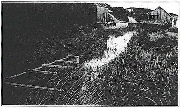
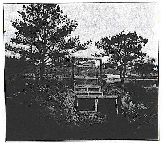
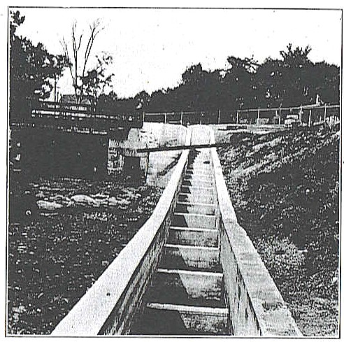
Many natural alewife fisheries have been aided artificially by extra canals, ditches and sluiceways constructed for the purpose of facilitating fishing methods, and of increasing the decreasing supply in the coastal streams. Outlets which have become closed through natural changes have been artificially opened, and the fish permitted once more to frequent their old spawning grounds. In certain instances the headwaters of one stream have been joined to another by an artificial ditch, e.g., Snipatuit Pond and Mattapoisett River, John's Pond and Quashnet River, Long Pond and Herring River (Fig. 2).

On Nantucket and Martha's Vineyard the simple procedure of opening the brackish water ponds to the ocean by cutting short ditches through the. sandy beach has been followed (Fig. 1). Owing to the shifting sand these ditches require reopening nearly every year. The alewife industries on Nantucket and Martha's Vineyard are good illustrations of the ability of man to create successful fisheries artificially. Since but few streams are found on these islands, the important fishing centers are located in the large ponds near the salt water. The artificial or partly artificial fisheries in Massachusetts naturally fall into three groups: —

Town-managed. — Very few artificial fisheries are now operated for the public, because the majority have been developed under long-term leases.

Privately owned. — More often these fisheries are owned outright by the individual or corporation who first acquired through

22a
Squibnocket

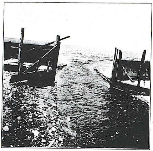
Fig. 1. — Outlet to ocean, Squibnockct Pond, Martha's Vineyard.

Harwich

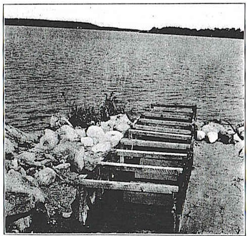
Fig,. 2. — Wooden runway at outlet, Long Pond, Harwich


23

legislative action the right to create the fishery, e.g., Nine Mile Pond Stream in Barnstable, and Childs River in Falmouth.

Leased. — Under the Acts of 18(39 the Fish and Game Commissioners were given the privilege of leasing the great ponds for a suitable period of time, for the purpose of cultivating useful food fish. The system of leasing shore ponds for maximum periods of twenty years by incorporated companies for the purpose of establishing alewife fisheries has been popular on Martha's Vineyard, and special privileges have been given by the towns in which these ponds are located. The important fisheries on Martha's Vineyard, e.g., the Mattakessett Creeks at Edgartown, and Tisbury Great Pond at West Tisbury, have operated under such special legislative acts. These semi-private fisheries have reached a most successful state of development.

Methods of Catching.

The method of catching alewives are comparatively simple, but there are numerous modifications to meet the particular needs and diversified natural conditions of the individual streams. Originally all fisheries were free to the public, and every householder was given the time-honored privilege of obtaining alewives in whatever manner and at whatever times he desired. Later, when the towns first exercised their control over the alewife fisheries, certain places were designated by law as locations where alewives could be taken, and fishing was forbidden elsewhere on the streams. The catching places have been developed by building locks and pens in which the alewives on stated days are seined or dipped as they pass up stream.

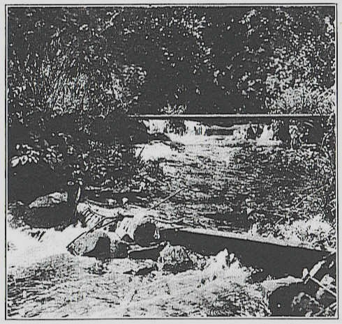
Implements. — Dip or scoop nets, traps or weirs, and seines are the principle implements for catching alewives. The fish are taken with dip nets in narrow parts of the stream, in specially constructed places (Fig. 4) and from seines or traps in which they have been caught. The scoop or dip net has a circular opening from 1 to 2 feet in diameter, and a handle from 5 to 7 feet in length. It is used to dip out alewives at the catching places. Along the Atlantic coast alewives are taken in pound nets, gill nets, seines, fyke nets, traps and dip nets.

24

All sorts of netting contrivances ranging from small fyke nets to miniature fish traps are set in the streams. At the entrance of Town Brook, Plymouth, an almost perfect fish weir except for absence of a leader is used. The size of the stream in general regulates the size of the trap. Before the alewives reach the rivers in the spring they are taken in the salt-water traps with other fish, sometimes in appreciable numbers, much to the disgust of the holders of the fishing privileges on the streams. If these traps are situated at or near the outlets of alewife streams in such manner as to obstruct the run, their presence constitutes a menace to the fishery.

On Taunton and North rivers, seining privileges are sold by the various towns to the highest bidder, under various stipulations as to size of seines, location and time of operating. On the Taunton River thirteen seining privileges are divided among the riparian towns, but in most cases permission is given the purchaser to operate at any point on the river. In recent years the value of these privileges has seriously declined, and at present several are not in use. An important part of the voluminous legislation on Taunton River alewife fishery is concerned with restrictions as to the maximum length of seine, time of purchase, selection of locations, and establishment of prohibited areas.

This method of capture employs the common drag seine, which is played out from the stern of a skiff with one end attached to the shore. After the seine has been set, the skiff is swung back to shore, which explains the legal restriction that the length of the seine should not reach across the stream. The seine is then pulled upon the shore, and the fish removed.

Foreign Methods. — In Scotland the sea herring is taken by seining and by drift or set gill netting, each method having its own advocates. The success of either evidently depends upon the locality and the conditions under which it is used. The purse seine has the advantage of being used without a landing place, and does not interfere with other nets, allowing a larger catch with fewer nets. Usually these seines are 150 to 180 yards long and 20 fathoms deep, and are operated from the boats with crews of four men each. A mesh of 33 to 35 per yard is said to capture small unsalable fish. The drift nets

25

with a 31 to 34 mesh per yard float in the water near the surface, while the set nets are anchored at the bottom.

Screen. — The simplest method of catching is to place a screen across the main stream to prevent the passage of the alewives, and to dip them when they congregate in sufficient numbers. During the days on which fishing is not permitted the screen is lifted, and the fish are allowed a free run to the spawning grounds.

Regulation of Water Flow. — An ingenious means of regulating the water flow at the catching station on the Agawam River prevents the alewives from ascending above a certain point on the catching days. The greater volume of water passes over the south dam, forming the main stream, and the catching pool, where the fish are taken with dip nets. From this stream a fishway, part of which is underground, after a course of 100 yards, leads into the mill pond. At the dam the gates are so arranged that the men operating the fishery can regulate the flow of water to fill the catching pool to the proper height during the fishing days. Just below the fish house, which is located over the stream, is a gate which is regulated by the herring committee. This gate when down forms a temporary dam which raises the height of the water in the catching pool so that the fish can ascend a 2-foot rise from the catching basin into a second pool connected with the fishway. When the gate is removed during the fishing days the water in the pool is lowered to such an extent that there is an insurmountable fall of 3 to 3 1/2 feet at the upper end of the catching pool.

False Channel. — At Herring River, Wellfleet, on catching days, the alewives run into a false channel, the main stream being closed by a gate. The false channel, a deep horseshoe bend shut off from the main stream at its upper and lower ends by a screen and gate, is closed three days a week to give the alewives free passage to the pond for spawning, and opened for catching the remaining four.

Weirs. — Primitive brush weirs were used by the early colonists. Twine traps in the form of fykes and weirs are now used at times.

Stone Driveways. — In Parker River the alewives were formerly taken by the simple procedure of constructing a V-shaped

26

wall of rocks in the stream, the apex pointing up stream. At the apex was placed a set net, 18 to 20 feet long, into which the fish were driven from the stream below.

Fish House Passageway.— On Monument River, Bournedale, the fish are taken as they pass through a narrow runway beneath the fish house, the catcher dipping them directly into barrels or upon the wooden floor.

Catching Basins. — At Herring River, Harwich, the alewives are allowed to collect in a large basin or pool, the upper end of which is closed by a gate to prevent their passage up stream. From this pool the fish are removed by seining.

Seine Trap. — At Edgartown Great Pond and Mattakessett Creeks alewives are caught, as they enter the pond, in a trap set at night in Cracketuxet Cove (Fig. 3). Two seines are used to separate the runs of the two previous nights. The fish which have been in the trap longest are taken first, and are hauled in seines upon the beach. Wagons are backed into the water, and the fish transferred from the seines with dip nets. Provision is made for a free passage during non-fishing days, and for the exit of the alewives which have spawned by bending to one side an end of the seine trap.

In the brackish water ponds and large rivers the fish are usually taken by seining (Fig. 3). At Hummock Pond, Nantucket, the curious procedure is followed of raking the fish upon the shore with wooden rakes as they crowd into the opening through the beach between the pond and the ocean. In Maddequet Ditch, Nantucket, a large dip net 4 feet in diameter and 8 to 9 feet long, subconical in shape, is placed longitudinally in the stream, and raised by means of a large handle.

Marketing.

Alewives are marketed for food or bait either fresh, in cold storage or salted. The salted fish are shipped in barrels or, more rarely, packed in cases. By special care in curing and packing it is conceivable that choice brands with suitable trade names might be developed. Massachusetts alewives, although some are used for home consumption, are mostly shipped to the West Indies. The market for fresh ale-

26a

Mattakessett Creeks

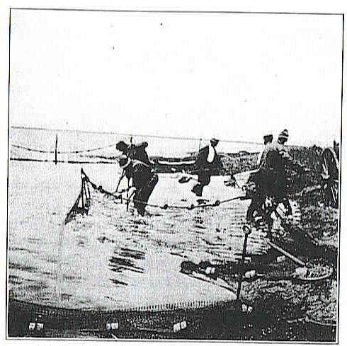
Fig. 3. — Seining alewives, Mattakessett Creeks, Edgartown.

Barker's River, Pembroke.

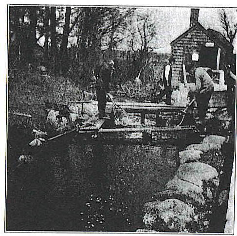
Fig. 4.— Catching alewives at Barker's River, Pembroke.

27

wives requires greater development, and the possibilities of canning the young for sardines and of utilizing the roe should also be considered.

Food Value. — The value of the alewife as a food is becoming more and more appreciated. In spite of its numerous bones it is a delicious fresh table fish and a nutritious food, easily preserved. Its proteid and fat content ranks well with our other food fishes. Milroy (7), in studying the food value of the sea herring, found that the total proteid and fat percentage at the spawning season was slightly in favor of the full and lowest in the spent fish. The alewives are taken when full of spawn. Nevertheless, outside of local home consumption the amount of alewives eaten fresh is comparatively small, since for shipment the fish is better marketed cured.

Salting. — In all curing or preserving operations the first essentials for the production of a first-class food are good fresh fish, care in handling and transporting, cleanliness and protection from weather conditions. The fish should be salted when fresh. Cleaning is advantageous, as it does away with the blood and those parts most liable to early decomposition, and gives the brine a better chance to penetrate. The extent of cleaning, if it is done at all, varies with the locality. There is little need of sorting, as the alewives run a fairly uniform size. No special standard is followed as to the amount of salt which is necessary for preserving since it depends upon the condition of the fish and their destination. Fat fish require more salt than lean, and cleaned fish less than those salted whole. Alewives sent to tropical countries, and those to be kept for long periods, should receive more salt. The fish are salted in layers in barrels and kegs, after they have been pickled in brine. The maximum weight of an alewife is one-half pound, the average ranging between one-third and two-fifths of a pound.

A Rhode Island method of curing is to place the alewives in the strongest possible brine for twenty-four to forty-eight hours, when they are turned over and stirred, with repetition of the process every two days. After one week they are packed as closely as possible in strongly made barrels, about 2 bushels of salt being used per barrel.

28

In the method used by Mr. George M. Besse of Wareham the undressed alewives are first covered completely with salt on the floor of the catching house, and then packed in a barrel in the bottom of which 2 inches of salt and an equal quantity of water have been placed. The alewives are placed in tiers with alternating layers of salt, and the barrel is filled half full of water. The fish remain in this "pickle" for about one month, when they are ready for dry salting, which consists in packing them in layers of "fine coarse" salt. In this form they are ready for the market.

Smoking. — In curing the alewives by smoking, the fish are removed from the brine, strung on sticks passed through the eye sockets, and then are suspended in suitable houses where they are dried and smoked. Later they are packed in boxes for the market or shipped in bulk. On Cape Cod it is not uncommon to see the picturesque sight of smoked alewives suspended in rows.

Price. — In the early runs good prices are received for the fresh alewives as bait. Prices fluctuate from year to year. Smith (4) quotes the price of 1.1 cents per pound in 1880; 0.9 in 1888; and 0.7 in 1896. In 1902 it averaged $3.75 per barrel, salted, and had so increased according to the May 26, 1919, issue of the "Fishing Gazette," that in 1917 alewives were selling at $6 per barrel at St. John, N. B., as compared with $4 the previous year. In 1920 prices ranged from $6 to $8 per barrel, salted, and $3 per hundred pounds fresh, while at the streams the freshly caught fish were sold from 50 cents to $2 per hundred count.

Scales. — In 1919 a new impetus was given the industry by the utilization of the scales for a secret commercial process concerning which it is impossible to obtain authentic information. Rumor is current that the iridescent coloring material of the scales is utilized in the manufacture of artificial pearls. Be that as it may, the firm of Petro & Finkelstein, at Hyannis, purchased quantities of scales during 1919 and 1920, and Mr. F. O. Proctor of Gloucester was carrying on an extensive business at Onset in 1920. The white lower scales only are taken and sell at 50 to 60 cents per pound, or higher, while the sealers receive a minimum of 10 cents per pound. At Herring River,

29

Harwich, twelve to fifteen women were engaged in the process of scaling the fish on May 11, 1920. It is estimated that 3 to 4 pounds of scales may be obtained from 1 barrel of alewives. The high value of the scales is shown by the great increase in the sale price of the Agawam River fishery which rose from $1,255 in 1919 to $11,000 in 1920. Whether this mushroom industry is a transient or permanent affair remains to be demonstrated. At any rate, it has markedly enhanced the value of the alewife fishery.

Statistics.

Since exact statistics are impossible to obtain because certain operators feel that business secrets will be revealed if they report the amount of their catch, our production figures are but approximately correct. However, more accurate figures, have been obtained from the annual sale of fishing privileges, as ordinarily these are a matter of town record.

Comparing recent with past years only two natural streams have maintained a high standard of production, — Agawam River, Wareham, and Herring River, Harwich. Among the artificial fisheries, Mattakessett Creeks and Tisbury Great Pond have yielded excellent returns. Two of the best natural streams — Monument River and Mattapoisett River — of late years have given inferior production, and require more careful regulation by their respective towns.

The streams north of Boston have shown the greatest decrease, since at present with the exception of the few alewives taken at Essex River and Weymouth Back River there is not a fishery in operation north of North River. Of the large rivers the famous fishery of the Merrimack has disappeared in the same manner as the earlier Charles, Mystic, Neponset and Connecticut River fisheries, while that of the Taunton has seriously declined.

Revenue. — The only accurate method at our disposal for determining the past condition of the fishery is a comparison of the revenues received by the towns from the leased streams. Even these figures are unsatisfactory, as they indicate the popular estimate of the worth of the fishery rather than its productive value, and only nine streams have consecutive records of the yield from leasing or town operating.

30

Herring River, Harwich, has shown increasing receipts. Agawam River since 1865 has brought an average return of $655.47, the highest net receipt being $1,352.50 in 1892, and the lowest, $55 in 1911. Both fisheries have maintained a high level, as did Monument River until 1912, when the construction of the Cape Cod Canal caused a most serious decline. In Jones River, between 1874 and 1913, the average revenue was $31.64, the highest being $101 in 1877 and 1881, and the lowest $12.33 in 1913, or, roughly, 12 per cent of the maximum. In North River the two seining privileges of Marshfield, which for the thirty years previous to 1900 averaged $34.85, from 1900 to 1912 brought an average of $3.40, or about 10 per cent of their former value.

Previous to 1875 the thirteen seining privileges in the Taunton River could not be sold legally for less than $100 apiece, and under sharp competition always sold at a high premium. At this date, owing to the scarcity of fish, a law was passed which allowed the various cities and towns to sell the fishery privileges at any price. During the past decade the three fishing privileges of the city of Taunton have sold for $5 apiece.

Average Annual Revenue to Towns from Alewife Fisheries.

Stream.

1870-79.

1880-89.

1890-99.

1900-09.

1910-19.

Agawam River,

$591 60

$539 20

$1,124 90

$427 25

$1,064 00

Bass River,

677 12

330 04

178 55

346 78

312 65

Herring River, Harwich,

349 00

401 00

558 00

645 00

1,107 50

Herring River, Wellfleet,

59 25

289 37

642 71

389 64

86 00

Mattapoisett River,

621 25

350 54

394 81

129 13

-*

Monument River,

-

91 99

633 42

477 96

961 65

North River
(seining permits, Marshfield).
68 27 64 96 25 81 5 19 4 10
Taunton River
(city of Taunton seining permits).
-
-
112 50 56 78 18 00

  Town Brook, Plymouth,

11 37

34 82

 76 94

 29 63

 139 09

* Deficit.

Production. — The accompanying table gives the approximate production for 1912, and the revenue derived by the towns from the various Massachusetts streams and ponds which at


31

one time possessed an alewife fishery. From the information acquired through the survey, the possible normal production and fair revenue to the town, if each fishery were successfully operated, has been estimated. The yield for 1912 amounted to 16,236 barrels, and the revenue derived by the towns to $4,370. The greatest production was at the Mattakessett Creeks, with $100 rental, and the highest rental $516, at Monument River, with one-half as large a catch, — an interesting comment on the proper revenue received by our shore towns.


Fishery.


Type.

1912.
Production in Barrels.

Possible
Annual
Production
 in Barrels.

1912.
Revenue to Town.

Possible
Annual
Revenue to Town.

Acushnet River,

Public,

—

—

—

—

Agawam River,

Leased,

1,250

3,000

$1,050

$1,500

Bass River,

Seining privileges,

700

2,500

800

1,250

Bound Brook, Cohasset,

Public,

—

100

—

50

Cape Pond, Rockport,

Public,

—

 —

—

—

Charles River,

Public,

—

—

—

—

Chathamport Alewife Brook,

Private,

—

—

—

—

Chebacco Brook, Essex,

Leased,

—

300

—

150

Childs River,

Private,

90

500

—

250

Cole's River,
Leased,
—

100

—

50

Coonamessett River,

Public and leased,

600

2,500

500

1,250

Danvers River,

Public,

—

—

—

—

East Falmouth Herring River,

Private,

—

—

—

—

Eel River,

Leased,

—

—

—

—

Falmouth Ponds (Fresh, Little, Oyster, Salt, Wing's).

Public,

100

500

—

250

Fresh Brook, Plymouth, Leased, —
200 25 100

Great Pond, Eastham,

Leased,

20

200

—

100

Herring River, Eastham,

Public,

—

—

—

—

Herring River, Harwich,

Leased,

1,500

3,000

700

1,500

Herring River, Wellfleet,

Leased,

290

600

25

300

Ipswich River,

Public,

—

400

—

200

Island Creek, Duxbury,

Public,

—

200

—

100

Jones River,

Leased,

—*

1,000

—*

500

Lee's River,

Public,

—

—

—

—

Long Pond and Parker River,

Private,

100

200

—

—

Marston's Mills Herring River,

Leased,

—

600

—

300

* Closed season.

32

Fishery.

Type.


1912.
Production
in Barrels.

Possible
Annual Production
in Barrels.

1912.
Revenue to Town.

Possible
Annual Revenue
to Town.

Martha's Vineyard Ponds: —


     Black Point,

Long lease, .

—

—

$100

—

     Chilmark,

Long lease, .

130

600

—

$300

     Edgartown Great Pond and Mattakessett Creeks,

Long lease,

3,000

5,000

100

2,500

     Farm, Long lease, — — — —
      Job's Neck,

Long lease,

—

—

—

—

      Kaleb's,

Long lease,

—

—

—

—

      Lagoon,

Long lease,

—

—

—

—

      Oyster,

Long lease,

5

200

25

100

      Pocha, 

Long lease,

—

300

—

150

      Sengatocket and Trap,

Long lease,

—

400

—

200

      Squibnocket: —


           (a) Squibnocket Herring Creek.

Leased,

125

400

—

200

            (b) Gay Head Herring Creek,

Leased,

266

2,000

21

1,000

      Tashmoo,

Public,

400

2,000


1,000

      Tisbury Great,

Long lease,

850

2,000

125

1,009

Mashpee River,

Public,

300

1,000

125

500

Mattapoisett River,

Town-operated
and leased.

325

3,000

—*

1,500

Merrimack River, Public, — — — —

Mill River, Sandwich,

Long lease,

75

500

—

250

Monument River,

Leased,

1,500

3,000

516

1,500

Mystic River,

Leased,

—

500

—

250

Nantucket Ponds (Hummock, Long Pond and Maddequet Ditch, Miacomet, Sachacha).

Public,

65

2,000

—

1,000

Nemasket River, Leased, 200 2,000 75 1,000

Neponset River,

Public,

—

—

—

—

Nine Mile Pond and Centreville River,

Private and seining.

125

500

—

—
North River, Public, 250 2,500
1,250

Palmer's River,

Leased,

—

2,500

—

1,250

Parker River,

Public,

—

100

—

50

Paskamansett River,

Public,

—

300

—

150

Quashnet River,

Private,

25

25

—

—

Red Brook, Cataumet,

Leased,

60

500

25

250

Red Brook, Wareham,

Private,

—#

800

—

—

Rowley River,

Public,

—

—

—

—

Santuit River,

Public,

50

600

—

300

Saugus River,

Public,

—

500

—

250

Scusset River,

Public,

—

—

—

—

* Deficit.     # Unknown.

33

Fishery.

Type.

1912.
Production
 in Barrels.

Possible
Annual
Production
in Barrels.

1912.
Revenue
 to Town.

Possible
Annual
Revenue
to Town.

Sippican River, Public, — 100 — $50
South River, Public, — 100 — 50
Sparrow Pond, Orleans, Public, — 400 — 200
Stony Brook, Brewster, Leased, 225 2,000 $60
1,000
Swan Pond, Dennis, Leased, — — — —
Taunton River (except Nemasket), Seining privileges, 3,500 7,000 80
3,500
Town Brook, Plymouth, Leased, 30
500 10
250
Wankinco River, Public, — 200 — 100
Weir River, Public, — — — —
Westport River, Public, — 400 — 200
Weweantit River, Public, 30
200 8
100
Weymouth Back River, Leased, 50
500 — 250
Weymouth Fore River, Public, — — — —
          Total
16,236 60,525 $4,370 $29,500

Statistics of United States Bureau of Fisheries. — According to Smith (4) the alewife fishery statistics for Massachusetts in 1896 were as follows: —


Traps.

Seines.

Gill
Nets.

Dip Nets

and Other.

Shore.

Boats.

Total.

Number of men,

5

223

5

121

46

—

388

Apparatus: —


     Number,

1

45

10

121

—

88

265

     Value,

$150

$3,075

$120

$193

$12,958

$2,974

$19,470

Number of fish,

2,564,587

4,949,106

18,000

2,514,233

—

—

10,045,926

Number of pounds,

1,331,202

2,629,525

10,125

1,385,637

—

—

5,356,489

Value of fish.

$9,842

$23,440

$180

$11,662

—

—

$45,124

Year.

Production.

Pounds.

Value.

1880, 

  3,751,059   

  $35,802

1888,

6,291,931 83,530

1898,

2,535,201 31,288
1902, 3,413,350 40,979

1908,

4,062,000 45,000


34

History and Legislation.

Early colonial records refer to the alewife as providing food for the first inhabitants of New England, and from the time when Samoset first taught the Pilgrims the method of fertilizing corn fields, this fish has had a considerable influence on the welfare of the country. Then the supply of fish was greatly in excess of the needs of the population, and every inhabitant who was a householder had the right of free fishing and fowling in any great ponds, bays, coves and rivers, as far as the sea ebbed and flowed. Higginson's "New Englands Plantation" mentions, in 1630, "Also here is abundance of herring" in the waters of New England, and Thomas Morton in his "New English Canaan," in 1632, remarks, "of herring there is a great store, fat and fair, and to my mind as good as any I have seen, and these may be preserved and made a good commodity at the Canaries."

Generally the alewife fisheries have passed through three periods, — development, state of maximum productivity and decline. From humble beginnings the fisheries became important public assets fostered by the shore towns. The period of transient prosperity was ordinarily followed by a decline in the natural supply, particularly on the more thickly settled streams, which was noticed as early as 1815. According to the records of The Colonial Society of Massachusetts: —

In the year 1730, the inhabitants (Plymouth) were ordered not to take more than four barrels each, a large individual supply indeed, compared with the present period (1815), when it is difficult for a householder to obtain two hundred alewives, seldom so many.

In spite of the attention given to the alewife fishery, this decline was permitted to extend until, in but few instances the old prosperous conditions have been maintained.

Our forefathers were not slow to recognize the importance of the alewife, and for its protection early passed many legislative acts, which best illustrate the history of the fishery. For the most part these laws were local and especially adapted to the needs of the individual fisheries. The first fishery law, known as the Plymouth Colony Fish Law, was enacted in

35

1623 for the protection of the alewife. In 1682 further legislation was enacted, and in 1709 and 1727 an act was passed and amended for the prevention of all obstructions to the passage of fish in rivers, except mill dams. Failure to enforce these acts and the increasing number of dams, resulted in 1741 in an act which provided that a sufficient passageway be made through or around each dam from the first day of April to the last day of May annually, or in certain rivers for a period not exceeding sixty days as designated; that the owners of the dams be required to give a sufficient water flow for the young to pass down; and that the cost of installing fishways in dams erected before 1709 be borne by the towns, and the future maintenance by the owner of the dam. One or more persons were to be appointed at the annual town meeting to see that the passageways were opened according to law, and to regulate the taking of fish. Persons were forbidden to catch alewives in other manner than prescribed by the town, under a penalty of ten shillings for each offence.

In 1743 an additional act provided that upon the petition of a dam owner the court should appoint a committee of three disinterested persons to inspect the dam, determine exactly what kind of a fishway was necessary, and what regulations should be enforced concerning it. Their decision when accepted by the court was adjudged the lawful rule for that stream, although aggrieved parties had the right of appeal, and could ask a second inspection by the court. In 1745 the mill owners by means of political pressure, obtained a provision abolishing fishways, provided the fish did not pass up stream in sufficient numbers to be of greater benefit than the damage from loss of water power due to the opening of the dam. The acceptance of a report of a committee appointed by the courts freed the owner of the dam from all obligations to make or keep open any passageway. It was also stipulated that no dam owner should be liable to any penalty for not keeping open a passageway through his dam in rivers or streams where no salmon, shad or alewives were found.

Subsequent legislation for the most part has been purely local in character, and extremely voluminous. Even at the present day the alewife streams are carrying the burden of much

36

antiquated legislation, e.g., the Taunton River fishery, which is operating under a law passed in 1855. The non-enforcement or subsequent modification of these laws in the interests of private individuals brought about the decline of the alewife fishery. Sufficiently good legislation was enacted for nearly every alewife stream, which, if properly enforced, would have preserved the fishery.

Since the provisions of the numerous laws enacted for the individual fisheries have many points in common, a summary of a few of the more important will suffice.

Establishment. — The first legislative act established or created a particular fishery by law, and placed the necessary responsibility upon the town, individual or corporation controlling the same.

Obstructions. — The general principle that alewives should have free passage up to the spawning grounds has been the keystone of all legislation. Various efforts have been made to provide all dams with suitable passageways for the fish.

(1)  During a period of sixty days, usually between definite dates, which varied as to the locality, stream and time of run, an open passageway was required.

(2)  Ordinarily any passageway sufficient for the fish was deemed satisfactory, and the owner could either bring the stream down to its natural level by removing the flashboards, or construct a fishway of sufficient size to permit the passage of the fish. In a few cases a passageway of definite size and flow of water was required, e.g., Beaver Brook, a tributary of the Merrimack, where a fishway not less than 6 feet wide, in which the water should not be less than 6 inches deep, was ordered.

(3)  The cost of installment and maintenance was borne generally by the dam owner, although sometimes by the town.

(4)  In some cases provision was made for a passageway for the young alewives returning to salt water in the fall.

(5)  Penalties of varying severity for obstructing the passage of fish were enacted.

(6)  Power was given to the selectmen or herring committee to remove all obstructions of any nature at the expense either of the owner or of the town.

Herring Committee. — The early laws provided for the ap-

37

pointment or election of one or more fish wardens for their enforcement. As time passed, the duties of the fish wardens were taken over by a herring committee elected at the annual town meeting. These men, varying in number from 3 to 9, had complete charge of the fishery, the town having previously designated the manner in which the fishery should be disposed of. They determined the time, place and manner of taking the fish, operated the fishery if run by the town, leased it to the highest bidder, drafted regulations, posted notices, and removed all obstructions, having the right to cross the property of any person in the performance of their duties. When several towns were concerned with one fishery, a joint committee comprising members from each of the towns performed these duties. Some received a suitable salary, others a nominal sum,' and still others no compensation whatever for their labors. Their powers were great, and the success or failure of the fishery invariably depended upon their judgment. Failure to appoint fish wardens or a committee sometimes rendered the town liable to a fine. Special wardens and inspectors for the enforcement of the laws were appointed by the committee from time to time.

Catching Days. — Usually there were three fishing days a week, although the period for catching alewives varied from one to six days. All sorts of combinations have been devised, ordinarily the first part of the week being devoted to catching. The days have been grouped, alternated and variously separated. Every day in the week except Sunday has been used. In some instances, catching days in several towns on one stream have so overlapped as to cause an almost continuous open season. The starting time was either sunrise, sunset or midnight.

Season. — The season for catching alewives ranged from the middle of March to the middle of June, usually being about sixty days, from April 1 to June 1. The capture of alewives out of season was prohibited by law, with numerous penalties. At sundry times closed seasons were declared by certain towns, and fishing prohibited for a brief period of one to three years, for the purpose of replenishing the fishery.

Locality. — Fishing was ordinarily limited to certain localities, which were selected by the herring committee, and at which the catching stations were located. Seining permits gave

38

a wider range, but were usually restricted to a definite station. Fishing was prohibited in other parts of the stream except those designated by the committee. Special provision was made to prevent fishing within a certain distance of any fishway, or on the large rivers near the entrance of tributary streams up which alewives ran. Not infrequently, no regulations were made governing the fishing which was carried on at any point.

Seining. — Permits were sold for seining on the larger streams, which required both the selection of a definite station and certain specifications regarding the maximum length of net, regulated usually in respect to the width of the stream.

Indians. — In a few instances, as at Bournedale and Mashpee, special provision was made for the Indians. At the Bournedale fishery the head of every family of the Herring Pond Indians was entitled to one barrel free.

Pollution. — In a very few cases specific reference was made to the prohibition of trade waste pollution.

Penalties. — All sorts of fines and penalties are to be found, ranging from a few dollars up to a maximum of fifty, with forfeiture of apparatus. Numerous provisions for obtaining this fine, and its subsequent disposal to county, individual informant or otherwise, were included. The different infringements of the laws called forth a variety of penalties.

Public Rights and Sale. — Originally all the fisheries were free to the public. With the few exceptions of artificially created private fisheries, and the Weymouth fishery, which was sold by the town to the Weymouth Iron Company, the fishery was operated or leased by the town. The public rights were satisfied by the requirement that a certain number of fish be supplied each household head, or that each householder, by seasonable application at the place of capture within a specified time, had the privilege of purchasing several hundred alewives at the price of 16 to 25 cents per hundred. At Weymouth the purchaser of the fishery, if unable to furnish alewives at this price, was subject to a fine of $5. Provision was sometimes made for supplying the needy poor and widows, free of charge, with a certain number of alewives. In the early days, when the fisheries were operated by the town for the direct benefit of the townspeople, men were appointed to catch the alewives

39

and sell them at a moderate sum. Provisions for the sale of the privilege were made at town meeting or at such time and under such regulations as the herring committee might decide, and the money accruing therefrom was turned into the town treasury.

Torching. — Torching of alewives was prohibited in 1819 on the Monument River, and in 1840 on Weymouth Fore River.

Restocking. — In streams with impassable dams, provision was made for carting a minimum number of mature alewives to the spawning grounds, and in this way a fishery was maintained at Weymouth Back River, Smelt Brook, Jones River, Kingston, and Town Brook, Plymouth. In 1881 the selectmen of Pembroke were required to deposit alive and in good condition, not less than 10,000 alewives, annually, in the Indian Ponds, the expense to be shared by all the towns on the North River.

In the following table the dates of legislation on certain important topics have been recorded for the individual streams: —

40-41


Fishery
Establishment
 of Fishery.
Appointment
 of Herring Committee.
Provisions
 for Passageways
 around Obstructions.
Specifications
 of Water Volume for Fishways.
Fishing
Restrictions
— Nets (Size, Number, Mesh).
Fishing
Restrictions
— Place of Operations.
Appointment
 of Wardens.
Limitation
 of Fishing Period.
Prohibition
 of Torching,
Closed
Seasons.
Prohibition
 of Ice Fishing.
Requirement
 of Town Stocking of Fishery.
Fishery
 Sale Privilege
vested in Town.
Provision
 for Sale to Public.
Achushnet River,
1790
1790
1883
1790
— 1790
1790
— 1790
— — — — — —
Agawam River, 1838
1838
1860
1838
1853
1860
— 1853
1860
1838
1860
— 1838
1853
— — — — 1860
1838
Bass River,
— 1849
1814
1849
— 1814
1849
1814
1849
— 1814
1849
— — — — 1849
—
Bound Brook, Cohasset,
1800
1800
1852
1800
1852
— 1800
1852
1800
1852
1800
1800
1852
— — — — 1800
1852
1800
Cape Pond, Rockport,
1816
1816
1816
— — 1816
— 1816
— — — — — 1816
Charles River,
1798
— 1813
— 1826
1826
1826
1813
1826
— — — — 1815
1826
—
Chathamport Alewive Brook,
— — — — — — — — — — — — — —
Chebacco Brook, Essex,
1809
1879
1809
1809
— 1809
1809
— 1809
— — — — — —
Childs River,
1798
1798
1847
1798
— 1798
1849
1798
1847
— 1798
1847
— — — — 1847
—
Cole's River,
1882
— 1882
— 1882
— 1882
1882
— 1882
— — 1882
—
Coonamessett River,
1798
1798
1825
1847
1798
1825
1847
— 1798
1847
1851
1798
1847
1858
— 1798
1847
1858
— — — — — —
Danvers River,
1781
1781
1806
1781
1806
1814
1781
1781
1806
1781
1806
— 1781
1806
— — — — 1806
1806
East Falmouth Herring River,
1863
— — — — — — — — — — — — —
Eel River,
1865
— — — — — — — — — — — 1865 —
Falmouth Ponds:—


     Fresh,
— — — — — — — — — — — — — —
     Little,
— — — — — — — — — — — — — —
     Oyster,
— — — — — — — — — — — — — —
     Salt,
— — — — — — — — — — — — — —
     Wing's,
— — — — — — — — — — — — — —
Fresh Brook, Plymouth
1798
1798
1798
— — 1798
— 1798
— — — — — 1798
Great Pond, Eastham,
1879
— — — — — — — — — — — — 1879
Herring River, Harwich,
1787
1787
1787
— — 1824
— 1787
— — — — — 1813
Herring River, Wellfleet,
1700
1788
1788
— 1788
— 1836
— — — — — 1836
1865
—
Ipswich River,
1788
1802
1803
1788
1803
1805
1814
1821
1825
1829
— 1814
1814
1856
— 1788
1803
1814
1829
1856
— 1868
— — 1803
—
Island Creek, Duxbury,
1799
1799
1799
— — 1799
— 1799
— — — — — 1799
Jones River:—


     Stony Brook, 1802
1802
1802
1872
— — 1802
— 1802
— — — — 1872
—
     Smelt Brook, 1802
1802
1802
1872
— — 1802
— 1802
— — — — 1872
—
Lee's River,
— — — — — — — — — — — — — —
Long Pond and Parker River,
1842
— 1842
— — — — — — — — — 1842
—
Marston's Mills Herring River,
1843
— 1843
1843
1843
1843
— — — — — — — 1843
Martha's Vineyard Ponds:—


     Black Point,
1898
— — — — — — — — — — 1898
— —
     Chilmark,
1850
— 1850
— — — — — — — — — — —

42-43

Fishery
Establishment of Fishery. Appointment
 of Herring Committee.
Provisions
 for Passageways around Obstructions.
Specifications
 of Water Volume for Fishways.
Fishing Restrictions — Nets (Size, Number, Mesh). Fishing Restrictions
 — Place of Operations.
Appointment of Wardens. Limitation of Fishing Period. Prohibition of Torching. Closed Seasons. Prohibition of Ice Fishing. Requirement of Town Stocking of Fishery. Fishery Sale Privilege vested in Town. Provision for Sale to Public.
Martha's Vineyard Ponds — concluded.


     Edgartown Great Pond and Mattakessett Creeks,
1783
1783
— — 1896
1783
1896
— — — — — — — —
     Farm,
1856
— 1856
— — — — — — — — — — —
     Job's Neck,
1881
1881
1881
— — — — 1884
— — — — — —
     Kaleb's
1857
1857
— — 1857
— — — — — — — — —
     Lagoon,
1857
1885
— — — — — — — — — — — — —
     Oyster,
— — — — — — — — — — — — 1890
1895
—
     Pocha,
1848
— — — 1856
1848
1856
— 1856
— — — — — —
     Segantocket and Trap,
1839
1840
— — — 1855
1855
— 1855
— — — — — —
     Squibnocket:—


          (a) Squibnocket Herring Creek,
1855
— 1855
— — — — — — — — 1855
— —
          (b) Gay Head Herring Creek,
— — — — — — — — 1863
— — 1863
— —
     Tashmoo,
1847 1847
— — — — — — — — — — — —
     Tisbury Great,
— — — — — — 1900
— — — — 1900
1910
—
Mashpee River,
1801
— 1801
1803
1874
— — 1801 — 1801
1874
— — — — 1801
—
Mattapoisett River,
1788
1788
1788
1803
— 1788
1803
1811
1803
— 1788
1811
— — — — 1788
—
Merrimack River,
1783
— 1790
1793
1804
1811
1819
— 1790
1811
1819
1867
1874
1881
1884
1790
1808
1811
1812
1819
1867
1874
1790
1811
1867
1790
1874
1881
1819
1867
— — — —
Mill River, Sandwich,
— — — — — — — — — — — — 1871
1904
—
Monument River,
1834
1871
— — — 1834
1834
1853
1854
1834
1834
1871
1904
— — — — — —
Mystic River,
1789
1789
1789
— 1789
1789
1789
— — — — — — 1635
Nantucket Ponds:—


     Hummock, 1876
— — — 1876
— — 1876
— — — — — —
     Long Pond and Maddequet Ditch,
— 1841
1841
— 1875
1875
— — — — — — — —
     Miacomet,
— — — — — — — — — — — — — —
     Sachacha,
— — — — — — — — — — — — — —
Neponset River,
1797
1797
1797
— — — — 1797
— — — — — 1797
Nine Mile Pond and Centreville River,
1860
— 1860
— — 1879
— — — — — — — —
North River:— 1790
1790
1790
— 1790
1811
1814
1853
1790
1811
1814
1853
1881
— 1790
— — — 1881
— —
     Barker's River,
1790
— 1856
1856
— — — — — — — 1865
— —
     Indian Head River,
1792
1792
1792
— — 1792
1881
— 1792
1881
— — — — — —
     First Herring Brook,
1818
— — — — — — — — — — — 1818
—
     Second Herring Brook,
— — — — — — — — — — — — — —
     Third Herring Brook,
— — — — — — — — — — — — — —

44-45
Fishery Establishment of Fishery. Appointment
 of Herring Committee.
Provisions
 for Passageways around Obstructions.
Specifications
 of Water Volume for Fishways.
Fishing Restrictions — Nets (Size, Number, Mesh). Fishing Restrictions
 — Place of Operations.
Appointment of Wardens. Limitation of Fishing Period. Prohibition of Torching. Closed Seasons. Prohibition of Ice Fishing. Requirement of Town Stocking of Fishery. Fishery Sale Privilege vested in Town. Provision for Sale to Public.
Palmer's River
— — 1820
— 1804
1836
1844
1852
1836
1844
1836
1844
1852
1804
1836
1844
— — — — 1836
1844
—
Parker River,
1793
1808
1837
1805
1812
1793
1808
1808
1808
1793
1808
— — 1808
— — —
Paskamansett River,
1792
— — 1792
— — 1792
1792
— — — — — —
Quashnet River,
— — — — 1864
— — 1864
— — — — — —
Red Brook, Cataumet,
1900
— — — — — — — — — — — — —
Red Brook, Wareham,
— — — — — — — — — — — — — —
Rowley River,
1808
1808
1808
— 1808
1808
1808
— — — 1808
— — —
Santuit River,
— — — — — — — — — — — — — —
Saugus River,
1802
1802
1804
1852
1854
1877
— 1802
1804
1823
1852
1877
1802
1823
1852
1877
— 1802
1804
1823
1852
— — — — 1802
1802
Scusset Rover,
1854
— 1854
— — — — 1854
— — — — — —
Sippican River,
1808
1808
1808
— — — — — — — — — 1808
—
South River,
1817
1817
1817
— — 1817
— 1817
— — — — — 1817
Sparrow Pond, Orleans,
— — — — — — — — — — — — — —
Stony Brook, Brewster,
1787
1787
1787
1855
— 1787
1787
— 1787
1855
— — — — — —
Swan Pond, Dennis,
1842
— — — — 1842
— — — — — — — —
Taunton River,
1792
1793
1792
1829
1855
1879
— 1792
1793
1800
1815
1819
1832
1843
1855
1876
1792
1793
1800
1815
1819
1832
1843
1844
1855
1876
1792
1819
1843
1855
1793
1815
1819
1843
1844
1855
1876
— — — — 1793
1815
1819
1843
1855
1875
1793
     Assonet River,
1860
1890
— — — — — — — — — — — — —
     Mill River,
1798
— 1798
— 1798
1798
— — — — — — — —
     Nemasket River,
1792
1792
1815
1833
1855
— 1792
1815
1855
1896
1855
1863
1792
1815
1819
1855
1863
1871
1876
— — — — — 1792
1808
1815
1837
1855
1875
1792
1798
     Salisbury Plain River,
1797
1797
— — 1797
1797
— 1797
— — — — 1797
1797
     Satucket River,
1872
— — — — 1872
1875
1878
— 1872
— — — — 1875
—
     Town River,
1797
— 1818
1872
— 1824
1797
1824
— 1797
1824
— — — — 1824
—
     Three Mile River,
1788
1788
1788
— — — — 1788
— — — — — 1788
Town Brook, Plymouth,
1789
1865
1789
1789
— — 1789
— 1789
— — — — 1865
1789
Wankinko River,
— — — — — — — — — — — — — —
Weir River,
1805
1805
1805
— 1805
1805
— 1805
— — — — — —
Weweantit River,
1798
1798
1798
— — 1798
— 1819
1798
1877
— — 1798
1798
Weymouth Back River,
1801
1801
1825
1801
1825
— 1801
— — 1801
— — — — 1801
1846
1846
Weymouth Fore River,
1799
1799
1817
1799
1817
— 1799
1817
1799
1817
1840
— 1799
1817
1840
— — — 1799
1817
1799
1817

46

THE CAUSES OF DECLINE.

While in some streams the alewife fishery has held its own, or even improved, it has diminished in others to such an extent that we can accept the general statement that there has been a serious decline. With the increasing prices and the development of artificial fisheries, production statistics give but a partial view of the situation, which can be obtained only by an intimate knowledge of each stream. The harmful effect of this decline upon the shore fisheries has already been explained, and few more convincing arguments can be advanced in favor of replenishing all possible alewife streams than its influence upon the future welfare of the shore fisheries of Massachusetts.

The causes which have contributed to this condition are so numerous and so complex that the separate influence of each cannot be absolutely determined. Both natural and artificial changes have brought about this decline, although the latter are by far the more destructive. Four prominent causes are: (1) -destruction of the spawning grounds; (2) obstructions which prevent the alewives from passing to the spawning grounds; (3) pollution of streams; and (4) overfishing, the result of unwise regulation.

Destruction of Spawning Grounds.

Many alewife streams which once were important can never be restocked because their former spawning grounds are no longer available. Among the various upheavals resulting from natural causes may be mentioned the lessened volume of water as a result of extensive deforestation, changes in the location and form of the outlet, and lowering of the water level in the ponds. The extensive cutting of forest land has altered the water flow in certain streams. Forests act as huge absorbent blankets, which catch and retain the rainfall. Without this protection the rainfall passes quickly into the streams causing soil erosions and heavy freshets, and streams in which alewives once could easily ascend to the headwaters become difficult of access. The lowering of the water level through natural agencies, of less frequency than artificial means, may result in a new outlet or a permanent closure.

47

Permanent damage has resulted from the taking of spawning ponds for water supplies and diverting or screening the original outflow. The former prosperity and number of the alewife streams can never be regained, since the extent of the artificially created spawning grounds can in no measure compensate for the great loss of natural territory taken for water supplies. The constant use of the water either so reduces the level that it will not flow out through its former outlet in sufficient quantity to allow alewives to enter the pond, — e.g., Wenham Lake and Cape Pond, — or reduces it to such an extent that during the period of low water in the fall the young alewives are unable to leave the pond, as at Great Quitticas Pond. To avoid the serious nuisance of dying fish clogging the water mains it has been customary to screen the outlets in the spring to prevent the entrance of fish.

Geographically the greatest damage has occurred north of Plymouth, as can be seen by the accompanying list of streams wholly or partly ruined by the use of the spawning grounds for water supplies.

Spawning Ground.

River.

Water Supply.

Suntaug Lake,

Ipswich,

Peabody.

Wenham Lake,

Miles (Ipswich),

Salem.

Cape Pond,

Mill,

Rockport.

Lake Quannapowitt,

Saugus,

Lynn.

Accord Pond,

Weir,


Lily Pond,

Bound,

Cohasset.

Ponds on First Herring Brook,

North,

Scituate.

Silver Lake,

Jones,

Kingston

Great South Pond,

Eel,

Plymouth.

Great Quitticas Pond,

Nemasket,

New Bedford.

Assawompsett Pond,

Nemasket,

New Bedford.

Acushnet Reservoir,

Acushnet,

New Bedford.

Naturally, the question of a good water supply is far more important than the existence of an alewife fishery. It is inevitable that other ponds, such as Chebacco Lake, Essex, may later be taken for this purpose. In most of these cases it is utterly impossible to restore the alewife fishery, although in

48

some places, e.g., Assawompsett Pond, it has not been seriously impaired. While we deplore the injury to the fishery, we must consider the problem from a broad point of view, and remember that these ponds have been put to a more universal use.

Obstructions

The first step in the development of a fishery is the removal of all obstructions in order to give free passage to the spawning grounds. Natural changes may alter the course of flow, as the change in the outlet of North River by the gale of 1898. Less extensive changes, mostly artificial, have occurred in other streams, which have had more or less effect upon the migration of the alewife. Natural or artificial falls, dams, unless equipped with fishways, and material of various kinds prevent or make difficult the passage of alewives.

Material. — Wire or wooden fences, rubbish and old ruins which have been placed or have fallen into the stream are the most common form of artificial obstructions, e.g., Chebacco Brook (Fig. 8). Luxuriant vegetation may completely or partially choke a stream, e.g., wild rice in Herring River, Wellfleet (Fig. 6). In certain localities the natural bed of the stream has been so altered by dredging or narrowing that the incline has become too steep and the flow too rapid for the easy passage of the fish. Narrowing the stream by drainpipes of insufficient diameter for the volume of flow may bring about well-nigh impassable conditions. The private screening of any alewife stream for duck raising or other purpose should not be permitted unless sufficient space is left for the passage of the fish.

Dams. — Dams are the inevitable result of the inroads of colonization following the waterways. In former days water power was even a greater necessity than in the present era of coal, gas and electricity. As manufacturing became of greater moment more power was required, and eventually numerous dams were erected on the streams of Massachusetts. Following the early settlements the coastal streams were first affected, and in the old laws can be traced the inevitable conflict between fishery and manufacturing interests, with the balance of power resting with the latter.


48a

Flooded cranberry bogs, Mattapoisett River.

Fig. 5. — Flooded cranberry bogs, Mattapoisett River.

Herring River, Wellfleet.

Fig. 6. — Obstruction with wild rice, Herring River, Wellfleet.


48b

Marston's Mills Herring River.

Fig. 7. — Neglected herring ditch, Marston's Mills Herring River.

Chebacco Brook, Essex River.

Fig, 8 — Obstructing material in Chebacco Brook, Essex River.

49

The mere presence of dams is not dangerous. Only when they are unequipped with fishways, or are not opened during the spring run, do they become a menace. Properly supplied with adequate passageways, dams would never have exerted a pernicious influence upon the alewife fishery. In nearly all instances the laws contained specific provisions for fishways in dams, but frequently these provisions were modified or repealed through the influence of the mill owners.

Dams have proved injurious to the alewife fishery by the direct obstruction of the passage of the fish to the spawning grounds, even when the gates are raised at certain seasons, for the reason that the sill of the dam, the lowest point to which the water may be lowered, is too high above the natural level of the stream, thus rendering difficult or preventing the advance of the alewives. This latter condition is especially prevalent in the small cranberry dams, which the owners usually open during the spawning season to permit the run of alewives.

The return of the young alewives to salt water in the fall presents a separate problem. At this season there is a minimum flow of water, scarcely sufficient for power or other mill purposes, and little water passes over the spillways. The young alewives following the main flow of water are carried into the flumes and through the mills, where according to general opinion, they are destroyed in the turbine water wheels. As yet no experiments have been made to determine the per cent of fish destroyed in passing through different types of water wheels, but until more definite information is forthcoming the best policy is to screen the flumes and furnish a passageway down stream at a minimum expense of water.

Impassable dams have undoubtedly been the immediate cause of the decline of many fisheries, and a direct relation can be shown between the number of impassable dams on a stream and the condition of the fishery, e.g., Indian Head River, Merrimack River, Ipswich River, Weweantit River and Acushnet River. The old laws regarding dams were well adapted for the protection of the fishery, the decline of which was not due to a lack of good laws, but rather to the non-enforcement of existing legislation. The only remedy for an obstructing dam is the installation of a passable fishway, with which every dam

50

upon alewife streams, unless opened regularly during the spring, should be equipped. At the present time too few dams are equipped with adequate fishways.

Cranberry Bogs. — A water supply is essential for the successful operation of the cranberry industry, and in southern Massachusetts numerous bogs are found along the alewife streams. Cranberry bogs are designated as dry or wet. In the former the water is pumped from a pond or reservoir upon the bog, where it is held until released to drain back into the pond. In the latter the bog is flooded by damming the stream which runs through it (Fig. 5). Little damage results from the dry bog, except for an infinitesimal amount of chemical pollution from spraying, the lowering of the water level in the pond, and, where the intake is not screened, the destruction of a few small fish. The wet bog, however, has become a serious menace to the alewife fishery, causing either partial or complete ruin in certain fisheries, e.g., Marston's Mills Herring River. The interests of the fishery and the cranberry industry are diametrically opposed. In the welfare of the latter the course of the natural stream is changed, channels made, water diverted by ditching, and dams erected for reservoirs or for flooding the bogs. Properly regulated, these changes could be accomplished without material damage to the fishery, but improperly controlled they have resulted in serious effects. The cranberry industry affects the alewife fishery in the following ways: —

 (1) The small dams are usually not equipped with fishways, and the owners are supposed to raise the sluiceboards during the annual run. However, at certain times the owners may find it expedient for the welfare of the bogs to have the water remain for a longer period, thus blocking or retarding the progress of the fish, although ordinarily there is little need of water over the bogs at the time of the spring run.

(2)  The course of the stream occasionally is changed by ditches and canals, which are inferior to the natural channels.

(3)  The young alewives descending to salt water are sometimes stranded by the temporary flooding of the bogs during the early fall, a condition which may be avoided by the use of screens or by careful flooding of the bogs.

51

The neglect of the town officials to force the cranberry bog owners to respect the rights of the alewife fishery has been the principal cause of the depletion of certain streams. The cranberry interests have been considered more important and more worthy of encouragement, since they yielded a greater revenue in the form of taxes.

The Marston's Mills Herring River may be cited as a concrete example of such neglect. This stream, once possessing a fair alewife fishery, capable of producing 500 to 600 barrels annually, to-day yields scarcely anything. The water is used for flooding cranberry bogs which line its course, and in its upper part a small pond has been raised by flowage to serve as a large artificial reservoir. Since the dam at this point unequipped with a fishway made the stream impassable, an unsuccessful attempt was made some years ago to provide access for the alewives to the spawning grounds in Cotuit Pond by an artificial waterway (Fig. 7). In 1913 the ditch was dry, and no alewives could or had passed through it for some time. The inevitable result was the ruin of the fishery because the fish could not get to the spawning grounds.

The fishery was established in 1843 by an act which provided that the selectmen of Barnstable should prescribe the manner, time and place for taking fish, regulate the course of the stream, remove obstructions, and determine the dates between which all dam owners should keep open a passageway for a period of sixty days. This law was amended in 1851, so that a committee was annually appointed and vested with the above powers, while dam owners were required to keep a free passageway for thirty days. Thus the entire regulation of the fishery and responsibility for its welfare rested on the town officials.

The attitude of the town officials was but the reflection of the indifference of the majority of the people who did not care whether the fishery existed or not. Because of its depleted condition and the lack of encouragement on the part of the town officials no one had purchased the fishery since 1903. In 1913 the selectmen were of the opinion that it would be poor judgment to interfere with the cranberry industry for the sake of a fishery which would bring practically no revenue to the town, whereas the cranberry bogs yielded an appreciable amount in

52

taxes. For that reason the town officials have never compelled the cranberry bog owners to construct fishways or open sluiceways, assuming, in view of the large taxable property, that their goodwill and influence would be more profitable than any direct value resulting from the fishery.

In its effect upon the shore fisheries the alewife is more important than its mere revenue to the town, and such a policy is extremely nearsighted, particularly since the fishery could have been preserved without injury to the cranberry interests if the town had not been negligent in its duty. Barnstable is not the only truant in this respect. Many other towns equally culpable should be sternly brought to realize the importance of the natural asset which they are foolishly wasting.

The cranberry interests and the alewife fishery are not absolutely incompatible. They can both exist without injury to each other if proper safeguards are taken. Conscientious oversight on the part of town officials and the whole-hearted co-operation of the cranberry bog owners are the only requirements. This co-operation does not mean the mere purchasing and nominal operation of the fishing right by the cranberry companies to avoid interference, as in Fresh Pond Stream, Plymouth, but the assumption of an active interest in the welfare of the fishery. The fishery interests can be safeguarded if the cranberry bog owners install suitable fishways or open the sluiceways at the proper times. Judgment in the location of ditches, dams, screens and other improvements, and co-operation in aiding the alewives in reaching the spawning grounds, is justly expected from cranberry producers.

Pollution.

Of the various problems confronting our fisheries the one which most demands immediate attention is water pollution. If allowed to increase, it means the serious depletion and even ruin of a great part of our inland and coastal fisheries, and the longer it remains unregulated the more difficult will become its ultimate control. Already it has made such inroads in our natural water resources that it is questionable whether many heavily polluted streams can ever be restored.

Sources. — Two kinds of pollution affect fish life, sewage and

53

trade wastes. Sewage enters the streams from private toilets and cesspools, and in the form of effluents from municipal systems. Owing to its prominence as a public health factor, methods of disposal have been devised by which it will be eventually fully controlled. If unregulated it damages water supplies and manufacturing interests, endangers public health through the contamination of edible shellfish, and is injurious to fish and fish environment. In 1920, after a thorough investigation, the Massachusetts Department of Public Health made a report (House, No. 1115), with recommendations for improving pollution conditions in the Taunton River and its tributaries.

Trade wastes include all forms of waste material from industrial sources. Fish preservation is chiefly concerned with this important type of pollution, which, in addition to rendering water unfit for drinking, bathing and for use in certain industries, directly and indirectly destroys fish life.

Effect. — Pollution may produce one or more of the following direct effects upon alewives: injury causing death or predisposition to disease, reduction of the oxygen supply in the water, rendering the fish unfit for food and driving them away from the streams. Indirectly it may cause the destruction of eggs and young, reduction of the spawning grounds, changes in bot-tom and vegetation, and limitation of the food supply.

Adult fish doubtless can stand a much greater amount of pollution than is ordinarily believed, and require a considerable quantity of concentrated pollution to kill in large numbers. Even in these cases it is difficult to prove cause and effect, as the damage is largely done by transitory pollution of varying strength and quantity. Little if any pollution occurs in the spawning grounds, and the susceptible young fish can be destroyed only as they pass down stream to the salt water.

Changes in the physical characteristics of a stream, in food forms, vegetation, oxygen content of the water, and other environmental conditions indirectly affect the fish life. Since slight changes in the water influence the movements of fish, the entrance of chemicals into the streams may have a marked effect upon the migration of the alewife.

Sewage. — Owing to the scattered nature of sewage pollution in the smaller streams its effect may be disregarded, but in the

54

larger rivers, such as the Taunton and the Merrimack, which receive a liberal amount, together with trade-waste pollution, it has a most disastrous effect. Unfortunately, in these cases we cannot accurately determine the relative influence of each. The following rivers receive an appreciable amount of sewage: Merrimack, Ipswich, Danvers, Saugus, Mystic, Charles, Neponset, Weymouth Fore, Weymouth Back, Acushnet, Taunton and its tributaries.

Trade Wastes. — Among the injurious trade wastes entering our alewife streams are acids, alkalies and miscellaneous chemicals from nail and iron works, rubber factories, wool-scouring establishments, bleacheries, laundries, dye works, leather factories, etc. Sulphuric acid, which is extensively used in the scaling process of the nail factories and iron works, in the rubber factories, and in wool-scouring establishments, causes the death of fish in a dilution of 1 part in 160,000, and interferes with their migration in far weaker dilutions. On Jones River an instance is reported where alewives held in a fish trap were killed by the waste discharge of the nail factories. The waste products of bleacheries, laundries and some manufacturing plants contain appreciable quantities of alkalies. Previous to the installation of filter beds and an alkali reclaiming machine at the New Bedford and Agawam Finishing Company on the Agawam River, East Wareham, dead alewives and shad were not infrequently found (Fig. 9). The company has established a method of removing alkalies from the waste products at a substantial saving. By means of settling basins and filter beds the waste products gradually enter the river in a less harmful form as a dark-brown liquid, which flows along the right bank 125 feet before mingling thoroughly with the stream (Fig. 10). During a run of alewives the fish were observed, upon reaching this material, to swerve to the opposite bank of the stream as if the substance were distasteful to them, but it did not seriously interfere with their spring run. Results have proved fairly satisfactory as long as this system has been adhered to.

The waste products of woolen mills, which contain a mixture of dyestuffs and chemicals, are the most numerous forms of pollution. The extent of injury from this type, although con-

54a

Shad killed by trade waste

Fig. 9. — Shad killed by trade waste pollution in Agawam River before installation of filter beds.

New Bedford and Agawam Finishing Company

Fig. 10. — Charcoal screen and filter bods of New Bedford and Agawam Finishing Company, on Agawam River.

55

siderable, depending upon the quantity of material, has never been completely determined. In the case of dyes the actual effect is by no means as bad as the appearance. Except in a few isolated cases saw mills do not permit their sawdust to enter the streams. The injurious effect of sawdust upon trout is well known. Hot water entering the stream in concentrated amounts quickly kills fish. Brook trout transferred from water at 55° F. to 85° F. die in two and one-half minutes. Chemicals used for spraying cranberry bogs are sometimes carried into the streams in drawing off the bogs, but ordinarily in such small amounts as to cause no harm. Arsenate of lead in a dilution of 1 part to 40,000 is toxic for trout in twelve hours.

The following coastal streams receive more or less trade-waste pollution: Acushnet, Charles, Danvers, Eel, Indian Head, Ipswich, Jones, Mystic, Nemasket, Neponset, Parker, Saugus, Taunton, Town Brook (Plymouth), Weir, Weweantit, Weymouth Fore and Back rivers.

Unwise Regulation.

The principal cause of the decline of the alewife fishery has been overfishing as a result of unwise regulation. Unless a reasonable number of adult alewives are permitted to reach the spawning grounds the destruction of any fishery is inevitable. Almost universally overfishing has been brought about by faulty methods of regulating the industry through town control, — a sad commentary on our lack of foresight.

Free Fishing. — The streams where the public is given the privilege of free-for-all fishing under various obscure regulations, most of which are seldom enforced, have become the poorest producers, and at the present time are the least valuable, although some offer possibilities for re-establishment. Laxity in town oversight and apathetic indifference on the part of the townspeople have brought about this state of affairs. Wise regulations are either not made, or, if enacted, are not enforced to insure the success of the fishery. People catch the alewives when and where they please, and the fishery passes from bad to worse because of unrestricted methods of fishing.

Town-operated. — Fisheries directly operated by the town are unsuccessful. Theoretically this method of control is ideal;

56

practically it is unsatisfactory because of lax management, town politics, unnecessary expense in hiring labor for nominal jobs such as patrolling streams, and inability to market the catch to the best advantage. The cost of maintenance is excessive, and the fish are riot sufficiently protected from overfishing. Almost the same lack of judgment in making regulations and lack of initiative in their enforcement is found as under a free fishing rιgime. If a town fishery could be placed on the same basis as a private enterprise it would undoubtedly prove a success, but such a situation can never occur as long as there exists a lack of personal incentive among the men hired to operate it.

Mattapoisett River is here cited as an example of an unsuccessful town-operated fishery, not because it is worse than others, but because it so well illustrates the effect of town control upon one of the best natural alewife streams. The fishery is controlled by three towns, — Rochester, Marion and Mattapoisett, subdivisions of the old town of Rochester. When Marion and Mattapoisett separated from Rochester, the alewife fishery rights of each in the Mattapoisett River were maintained. The fishery has been operated by the three towns, and the profits or losses have been proportioned according to the amount of taxable property in each town. Of recent years, instead of being an asset it has become an expense, since between 1908 and 1917 deficits rather than profits have resulted in a fishery which between 1861 and 1912 gave an average annual return of $825.67.

The decline of this fishery, which is strikingly shown by the following table, may be attributed to three causes, all of which might have been prevented by intelligent supervision: (1) so many fish were taken from the stream that insufficient numbers reached the spawning grounds; (2) the stream was allowed to become impeded by cranberry bogs and obstructions; (3) the expense of labor and materials in operating the herring weirs was unnecessarily high: —

57


Years. Total Income. Operating Expenses. Net Receipts.
1866-70, $7,186 92 $3,094 30 $4,092 62
1871-75, 6,367 58 3,175 48 3,192 10
1876-80, 5,193 72 2,337 83 2,855 89
1881-85, 3,069 16 2,464 98 604 18
1886-90, 4,400 91 1,855 25 2,545 66
1891-95, 4,971 63 2,131 29 2,841 34
1896-1900, 1,301 99 1,233 19 68 80
1901-05, 2,846 58 2,411 16 435 42
1906-10, 4,196 89 3,408 57 788 32
1911-15, 432 65 1,336 68 904 03*
1917-22, 525 00 _2 525 00

* Deficit.          2 Leased.

Leased. — The popular and easy expedient of leasing the fishery from year to year to the highest bidder has placed a premium upon its exploitation and has directly encouraged overfishing. Naturally the purchaser, uncertain of obtaining the fishery for the following years, would severely drain its resources. Yet this method of operation has been used by the majority of towns for years, merely because it had become a custom and was the easiest way of dismissing the problem. The minimum period of a lease should be five years, a method of procedure which has been adopted only by a few towns in recent years.

Sale. — Where fisheries have been artificially created by private companies under legislative acts the town has no powers. In cases such as Weymouth, where the town had sold its fishery, its responsibility did not cease, and it should have made the Weymouth Iron Company fulfill the provisions stipulated in the sale until it was again acquired by the town.

Joint Fisheries. — Where several towns are interested in the same fishery it is usually regulated by a joint committee. Compromises resulting from conflicting interests have not always worked for the best interests of the fishery, for example, by increasing the number of fishing days on a river, thus giving the alewives practically no free time to reach their spawning grounds.

58

Herring Inspectors. — The fishery is regulated by the herring committee or inspectors annually appointed by the town. Not infrequently this office, especially if salaried, becomes involved in town politics, and the administration of the fishery becomes a political, shuttlecock. Provided men who understand the needs of the fishery are elected and its welfare is put beyond petty local jealousies, this method of administration is the best which town control can offer.

Laws. — Laws have accelerated the decline of the alewife fishery by non-existence when necessary, harmful provisions, and, most important of all, by their non-enforcement. In addition to voluminous legislative acts there exist still greater quantities of town regulations, showing the influence of town politics and reflecting the varying condition of the fishery. In these laws may be traced the development of certain ideas for its administration. The most prevalent erroneous idea is that restriction alone is sufficient to preserve a fishery, and people have failed to see that restrictive laws, unless combined with constructive legislation, are valueless. The principal criticism of the present laws, in addition to their antiquated provisions, is their lack of uniformity. In place of the voluminous local legislation a few simple general laws capable of local modifications would aid greatly in the re-establishment of the fishery.

Town Responsibility. — The present method of town control is directly responsible for overfishing. The fishery, a town-regulated affair, has declined as a result of the evil practices which have grown up under this system. In many instances the attitude and ability of the town to manage a fishery is hopeless, and some method should be devised to force such careless and incompetent towns to conduct their fishery in a legitimate manner.

REMEDIAL MEASURES.

This investigation of the Massachusetts alewife fishery has shown it's present condition, the causes contributing to its decline, and has brought out certain points in the life history and habits of the alewife, which furnish a basis for establishing cultural methods.

The requisite steps in this reconstruction work are:—

59

(1)  An unobstructed and uncontaminated passageway from salt water to the spawning grounds.

(2)  Artificial restocking of depleted streams, and the creation of new fisheries in favorable localities.

(3)  Adequate and efficient methods of regulating the fishery.

Necessarily these steps will require time for completion, particularly in the enactment of careful legislation, and will demand the co-operation of all persons interested in the welfare of the fisheries. By this report the Division of Fisheries and Game has fulfilled its duty by showing the immediate need, and pointing out the way of reform. It has already helped, and will go still farther in assisting the towns to remove obstructions to the passage of fish in streams, and in restocking the spawning grounds. But the regulation of the fishery must come through the General Court and through the action of the individual towns in the form of efficient legislation. Without co-operation upon the part of the coastal communities all cultural efforts for its restoration are useless. To this end the shore towns should be thoroughly aroused to a sense of their responsibility for the protection of the alewife.

The first step in the reconstruction of the alewife fishery is the removal of existing obstructions, to make a clear passageway for alewives. The removal of obstructing material offers little difficulty beyond ordinary care on the part of the persons in charge of the fishery in keeping the stream clear. Two conditions present difficult problems: (1) impassable dams, and (2) pollution. The first and more important has been met by installing workable fish ways; the latter is still under consideration.

Fishways.

The fishway problem has been and always will be a difficult one to solve satisfactorily. So far a perfect fishway for alewives and shad has never been made, although all manner of designs are on the market. The reason why any single type is not uniformly successful is that in each case it must be adapted to the locality where installed, since different situations demand different kinds of fishways to meet their requirements.

Requirements. — The requirements for a successful fishway are: (1) easy and rapid passage for a species of fish, with uni-

60

form flow of water, gradual ascent and absence of high barriers; (2) a minimum sacrifice of water in the interest of the dam owners; (3) an entrance into which the fish are readily directed; (4) a firm, solid construction, resistant to freshets, or one which may readily be removed when not in use.

Existing Types. — There are three kinds of fishways in use on the ale wife streams at present, each of which has several modifications: —

(1)  Natural Stream. — The most successful type is not, strictly speaking, a true fishway, but merely a small side stream of gradual slope, connecting the pond with the main stream below. Projecting rocks, or even concrete bars (Fig. 11), help to check the current, and afford resting places for the alewives in their forward progress. This type is the most easily surmounted of all, but has the drawbacks of excessive waste of water, impossibility of installation in many locations, and difficulty in directing the fish into its entrance, since alewives follow the greatest flow of water, and therefore tend to pass up the main stream to pocket at the foot of the dam unless directed by a screen or barrier into the smaller stream.

(2)  Pool. — This form consists of a series of pools with a 1-foot drop in the level between each pool. It is usually of wood, concrete or stone construction, the number and size of the pools varying with the height of the dam. The old Lawrence fishway on the Merrimack River was of this type. Wherever this type of fishway is installed, its size, shape and length must be altered to correspond to the physical requirements of the dam.

(3)  Inclined Plane. — Various types of inclined plane fish-ways are in use, the most important being the Brackett. These fishways consist of a long, narrow box inclined at an angle equivalent to a 1-foot rise for every 10 feet, with various arrangements to check the flow of water and to afford resting pockets for the alewives. This type is the most popular form on our alewife streams, and seems especially suited for small dams, owing to the convenience of installation and its cheapness. Though occasionally of cement, as on Red Brook, it is usually of wooden construction. The most primitive yet effective type is made by placing 1-foot cross boards per-

60a

Stone fishway with concrete baffles, Nemasket River

Fig. 11. — Stone fishway with concrete baffles, Nemasket River.

Standard straight-run fishway of concrete

Fig. 12. — Standard straight-run fishway of concrete, Stanley Iron Works, Bridgewater.

61

pendicularly or at an acute angle at 3-foot intervals along the slope. Water flowing down the incline on striking these projections rises in wave-like crests. The alewives take these steps in a continuous passage by a series of rapid jumps. This fishway is satisfactory, provided that it is not too long, and that the slope is no greater than 1 to' 10. Another type has the crosspieces alternately set at an acute angle to the sides, thus retarding the sweep of the water. The Brackett fishway is more satisfactory, as it affords resting places for the fish, and insures easy progress. There are numerous fishways on the market labeled with the inventors' names, all of which under certain conditions are more or less successful.

Installation. — The chief point to remember is that it is not the type of fishway, but the way in which it is installed which determines its success or failure, since each dam presents certain peculiarities which necessitate individual treatment. In installing a fishway the following conditions must be considered : —

(1)  Water Flow. — Provision for a constant flow of water, irrespective of variations in the level of the pond, can be made by (1) an adjustable upper section of the fishway to correspond to the water level, (2) a gate situated at the lowest probable water line; and (3) several gates at different levels.

(2)  Entrance. — Instinctively the fish follow the greatest flow of water, usually up the main stream to the dam. Therefore either the entrance must be directly beneath the dam, where the fish will naturally swing into it, or there must be some means of directing them. Screening the stream with an iron grating is a successful though expensive method. A submerged stone barrier leading to the fishway entrance has proved at times effective.

(3)  Construction. — The nature of the soil and height of the dam largely influence the difficulty and expense of construction, necessitating a careful survey before exact plans are submitted.

(4)  Destruction. — Destruction of a fishway by spring floods may be partially avoided by (1) building a concrete structure; (2) locating the fishway where it is subject to the least damage; and (3) having part or all removable when not in use.

62

Standard Fishways. — A successful fishway which will take all species of anadromous fish has never been invented. In our work two types of fishways have been designed, which have proved highly satisfactory for the alewife streams and are adaptable to a variety of conditions. The accompanying illustrations (Figs. 12, 13, 14) indicate the details of these types, which have been developed by R. Loring Hayward, consulting engineer for the Division of Fisheries and Game and which are designated as the David and the straight-run fishways. No claim is made that these are the long-sought universal fishways, or that they are suited for other species of fish. We know that they are successful for alewives, and that their simple design makes them well adapted to Massachusetts streams.

The David fishway (Fig. 14) may be either of concrete or wooden construction. With its sloping bottom and irregular baffles it resembles the Brackett type, but possesses the additional qualifications of frequent rest pockets and a steady, uniform flow of water which is controlled by the upper gate. Although more expensive than the second standard type, it can be advantageously installed in a limited space over an irregular course.

The straight run fishway (Figs 12, 13) is especially adapted for low dams where the contour of the stream bed affords a gradual fall This primitive form of fishway more nearly resembles a natural swift flowing broken stream, and possesses the advantage of stimulating the rapid ascent of the alewives.

Chapter 365, Acts of 1904, requires that dam owners shall, at the request of the Division of Fisheries and Game, which furnishes complete plans and specifications for every fishway, install suitable fishways at their own expense, and keep them open at specified times, under penalty of a fine of $50 per day for non-compliance. Only through this law can the Division exert direct influence upon the rehabilitation of the alewife fishery. In spite of the difficulty in obtaining the willing co-operation of the dam owners, who naturally object to the expense of construction, the work of installing fishways is steadily progressing, and it is hoped that eventually all of the potentially productive streams will be completely equipped.

62a

straight-run fishway installed at Stanley Works, Bridgewater.

Fig. 13. — Plan of straight-run fishway installed at Stanley Works, Bridgewater.

62b

David fishway installed at Connecticut Mills Company, East Taunton.

Fig. 14. — Plan of David fishway installed at Connecticut Mills Company, East Taunton.

63

In 1918, 1919 and 1920 satisfactory fishways of the standard types have been installed at the dam locations of the Connecticut Mills, East Taunton, the Stanley Works, West Bridgewater, the Jenkins Leatherboard Company, Bridgewater, the Essex Mills, Lawrence, the Carver Cotton Gin Company of East Bridgewater, and the Ipswich Mills of Ipswich. Plans calling for the construction of like fishways, with some minor modifications, have been submitted for installation in the near future to the Easton Investment Company of West Bridgewater, the Locks and Canals Company of Lowell, and Mr. Benjamin Cummings of South Dartmouth.

Screens. — Of equal importance is the preservation from destruction of the young alewives by water wheels as they descend the streams in the fall. Suitable provision other than through the sluiceway of the mill should be made at each dam for the passage of the small fish down stream. In certain cases where large quantities of water are used this is a serious problem, owing to the fact that the water, during the fall, is too low to run over the spillway. In such instances the fishway should be kept open either continually or intermittently, so that the young alewives may have a passageway without a surplus waste of water. To prevent the young fish from following the greater flow, and passing into the sluiceway of the mill where they may be injured and probably destroyed in numbers, the mill companies should be required to install screens.

Pollution.

With the continuous growth of towns and cities, unless better methods of disposal are devised, and more stringent regulations enforced, the amount of water pollution is inevitably bound to increase. Since the alewife streams form part of this general problem, similar methods of treatment are necessary. The pollution question is so important, difficult and complex in its inevitable conflict with large manufacturing interests that to dismiss it in the few words necessitated by the limited scope of this paper seems most inadequate.

It is generally acknowledged that pollution destroys or injures fish life. Nevertheless, the immediate and ultimate effects


64

of the various kinds of pollution must be studied before we shall be in a position to determine the exact amount an alewife can survive immediately or over a long period of time. The effect of severe recent or transitory pollution in flagrant cases is conspicuously indicated by the presence of dead or dying fish. Yet unappreciable continuous pollution may be fully as harmful, due to the cumulative effect over a long period.

The following tentative plan of approaching the pollution problem has been adhered to. It deals with local conditions in a fishing and manufacturing state where the pollution evil which vitally affects the future of valuable fisheries is closely linked with the manufacturing interests, — a situation which renders especially difficult the application of remedial measures. Educational propaganda is under way, but no effort as yet has been made to use extreme legal measures in forcing the elimination of individual cases.

Education. — The financial antagonism of the manufacturing interests, both owners and employees, must be overcome, and indifferent public opinion aroused by a campaign of education. The evil effects of pollution can be presented to the public by lectures and newspaper articles; to the owners, by personal interviews and correspondence.

Survey. — Every source of pollution will be recorded, and the co-operation of the owner in its removal requested.

Disposal of Waste. — Through the expert advice of the State Department of Public Health, means of waste disposal at the least possible expense to the manufacturers are recommended.

Utilization of Waste. — The manufacturers are shown how they can utilize their own waste products to best advantage, and thereby reduce or completely eliminate the expense of maintaining a disposal system.

Legal Action. — As an extreme measure, if the owner refuses to co-operate, legal action for the elimination of pollution, as provided for under the present laws, may be instituted. Laws must be carefully drawn and sufficiently broad in their enforcement to facilitate the handling of difficult cases of transitory pollution, or where polluting material is surreptitiously emptied into a stream under pretense of a nominally operating disposal system.


65

Stocking Methods.

All stocking methods are based upon the Parent Stream Theory, which presupposes that the young alewives return as mature fish to the same waters where they were hatched. Depleted streams can be restored and new fisheries created by stocking, through the introduction of young alewives into the headwaters, which may be accomplished in two ways: (1) transplanting mature, ripe alewives to the spawning ponds; and (2) planting artificially hatched fry.

Until the first step, a free and unobstructed passageway, is accomplished, restocking the spawning grounds of depleted streams is a waste of time. Its success has been demonstrated in the case of the artificial fisheries which have been created by connecting fresh-water ponds with salt water, and by stocking them with adult alewives, and the maintenance of the fishery in streams such as Town Brook, Plymouth, and Smelt Brook, Kingston, where impassable dams exist, by placing a certain number of alewives each year in the headwaters.

Mature Alewives. — The yield of certain depleted streams has been greatly increased by transplanting into their headwaters spawning alewives from productive streams. It is sure, practical, and at the present time the only certain step for restocking unobstructed streams. It possesses the great objection of expense in catching and transporting the adult fish. Possibly small alewives could be seined in the late summer and similarly transported at a less cost.

This method of re-establishing depleted fisheries involves the successful transportation of the adult fish for various distances. The alewife is a delicate fish to transplant, resembling in this respect the white perch. If sufficient care be taken they may be transported successfully, but any lack of judgment is likely to have disastrous results. Four factors influence the outcome, — temperature, distance, number of alewives per can, and aeration. Hot weather renders transportation more difficult. The alewives are more likely to die on long journeys, and the amount of direct aeration and that obtained indirectry by jolting t>f the vehicle determines their survival. The selection of the proper number per can is also very important. The de-


66

tailed results of fifteen tests in transporting alewives in 10-gallon cans in a Ford car by one man are shown in the following table. Alewives can be carried a maximum distance of 48 miles, provided they receive proper aλration, are not overcrowded, and the temperature is not too high. The effect of temperature is shown by 17 per cent success at 81° F., as compared with 100 per cent at 65° F., in transporting alewives from Bournedale to Hingham. The result of overcrowding with 15, instead of 6, per can is shown by 27 per cent success, and lack of aλration, by 14 per cent.

Results with larger quantities, when large cans and a truck were used by the fish salvage crew in transplanting alewives from Bournedale to Long Pond, were less satisfactory, owing to the difficulty in aerating large numbers of cans, and to the warm weather.


Route.
  Date. 
Distance
 in Miles.
Time in Hours. Number
of Fish in Can.
Times Aλrated. Maximum Temp-
erature of Air.
Per Cent Alive.
Follin's Pond to Marston's Mills. May 12 15
1
15
4
68
27
Bournedale to Sandwich, May 13 5
1/4
7
— 68
100
Bournedale to Hingham, May 14 48
3
5
9
65
100
Sandwich to Little Herring Pond. May 13 7
1/2
5
2
68
100
Bournedale to East Sandwich. May 18 8
1/3
8
— 76
87
Bournedale to East Sandwich. May 19 8
1/2
7
— 81
100
Bournedale to East Sandwich. May 20
1/3
5
— 76
100
Bournedale to East Sandwich. May 20 8
1/3
7
— 76
100
Bournedale to East Sandwich. May 21 8
1/2
5
— 80
100
Bournedale to East Sandwich. May 21 8
1/2
6
— 80
100
Bournedale to East Sandwich. May 26
8
2/3
6
— 54
100
Bournedale to Hingham, May 21
48
3
6
— 80
17
Bournedale to Mattapoisett, May 19
22
1
7
10
81
14
Mattapoisett to New Bedford and East Wareham. May 19
30
3
6
1
81
—
Bournedale to Long Pond, June 9
7
1/2
5
4
68
100

Artificial Hatching. — The ideal method of propagation would be to plant artificially hatched alewives, and sufficient preliminary work has been carried out along this line to indicate that commercial hatching is feasible.


67

(1)  Ripe Fish. — The principal obstacle in artificial hatching is obtaining ripe fish for stripping. It is impracticable to obtain the fish in their journey up stream, since the ratio of males to females is large, and practically all the eggs are "green" at this time.

Holding the alewives in pockets until ripe on their way up stream offers a possible solution of this difficulty. Tests at East Sandwich indicate that confinement in small pools is unsatisfactory, as the eggs did not ripen and the fish eventually died from fungus. Fifty alewives taken at the Bournedale Stream between May 18 and 21, 1920, were held in a pool 8 by 50 feet in size, with wooden sides and sand bottom, in 1 foot of water, flowing 2,000 gallons per hour. The water came from a pond where alewives spawned naturally, and was of the same character as in the stream up which they normally ran. By June 9 all were dead, and no eggs had ripened.

Seining the fish on the spawning grounds seemed the logical method of approach. The ratio of male and female necessitates handling large numbers of superfluous males, as well as many unripe females. However, with labor and patience a sufficient quantity of eggs may be secured.

(2)  Protection of Spawn. — The possibility of protecting the spawn from the depredations of other fish by screening the spawning beds was considered, but the uncertainty of when and where the spawning would take place, and the fact that the fish which prey upon the eggs follow in schools close behind the alewives, rendered this idea impracticable.

(3)  Hatching. — When seined the fish are stripped by the usual method. After fertilization, owing to their adherent nature, the eggs mass together, but this may be obviated by constant stirring and by changing the water every five minutes until they "harden." Hatching takes place at 72° F. in forty-eight to ninety-six hours in open MacDonald hatching jars. The eggs at first adhere to each other, but later they separate. The fry, which have the appearance of fine transparent threads attached to a relatively large yolk sac, can be held only for a short time in tanks before planting.

(4)  Planting. — The advantage of artificial hatching over natural spawning is the protection of the egg from the inroads


68

of suckers and white and yellow perch, which frequent the spawning grounds. For protection from these fish the fry should be liberated over a wide territory.

In spite of the great difficulty in obtaining the ripe fish, the artificial hatching of alewives is a practical procedure, but the beneficial effects of planting the fry cannot be demonstrated for several years.

Regulation of Fishery.

The third important step in preserving the fishery is the proper legal regulation which will allow cultural and protective measures to achieve the best results. In place of the present voluminous special legislation, a few simple, readily enforced general laws, capable of local modification, should prove of great benefit in developing the alewife fishery.

The best method of operating the fishery would be a central board of control, with local representation, which would have adequate powers to enforce the laws, delegate authority, and regulate each individual fishery in the interests of the whole. Thus each fishery would be freed from local disputes and irresponsible manipulation.

Against this ideal method of regulation stands the desire of the coastal towns to control their respective fisheries, and for the sake of expediency an attempt at restoration must first be made under a system of town control, whereby each town is given charge of the fisheries within its bounds, subject to a definite policy of management defined in a comprehensive State law. In this way each town will be given the detailed management of the local needs of the fishery, but will be held strictly accountable by law for its proper regulation. The welfare of the fishery is the concern of the State, and no town has the moral right to squander an asset which has been intrusted to its care. Delinquent towns should be rigidly brought to account and made to take proper care of their fisheries. The Division of Fisheries and Game stands ready to advise and assist the towns in every way possible, but has no power in the local regulation of the fisheries. It can co-operate in fishway installation, and through stocking, but unless better town regulation is given, any work of this nature will be without avail.

To insure the correct regulation of the alewife fishery, all


69

existing laws must be replaced by a general law which, in addition to compulsory oversight by the State, will embrace the following provisions: —

Lease. — The fishery should be leased to private individuals. A long-term lease, not less than five years, is necessary, since the short-term lease places a premium upon exploitation. The longer period will encourage a purchaser to safeguard the fishery in all ways.

Closed Seasons. — Closed seasons are beneficial only when they are used to supplement and protect constructive cultural work. A closed season is of direct benefit to the alewife fishery when the alewives are given a chance to spawn in large numbers, thus supplying a natural means of stocking. In all cases of depletion at least a three-year period should be exacted, and the necessity of a further closed season determined by the results obtained, especially in cases where stocking operations have been simultaneously carried on. In fairly prosperous fisheries the one-year closed season alternating with the five-year lease should prove a good prophylactic measure for insuring the welfare of the fishery.

A partially closed season may be imposed by allowing the first part of the alewife run to reach the spawning grounds unmolested, before any fishing is commenced, thus insuring an appreciable amount of good-quality spawn being deposited by large first-run fish. The success of such a provision would depend upon the knowledge, judgment and care exercised by the herring committee in determining the proper fun of fish before fishing was permitted. Owing to the higher prices received for early fish, this method will scarcely appeal to the fishing interests.

Season. — The length of the season should be the same throughout the State, and not exceed a maximum of sixty days. The exact dates for the commencement of fishing should be determined for each individual stream.

Fishing Days. — The time of catching should not exceed three consecutive days per week. Any combination may be selected, but the period from sunrise Tuesday to sunset Thursday is recommended as giving the best opportunity for preparing and disposing of the catch.


70

Fishing Places. — To insure easy enforcement of the law, fishing should be conducted at definite places. Suitable equipment in the form of buildings, catching basins, etc., should be provided at these carefully selected sites. Only in exceptional instances should more than one catching place be allowed per town, viz., seining privileges on the larger rivers.

Methods of Capture. — The methods of fishing should be clearly and definitely stated. The length and size of mesh for seines should be regulated.

Uniform Sale. — The method of conducting the sale of the alewife fishery leases should be uniform as regards time of sale, submitting of bids, awarding of contracts, payment, forfeiture and all other provisions. A minimum price should be set for each fishery.

Herring -Committee. — A committee of three members should be chosen for a three-year period by each town, not by reason of their political influence, but because of their knowledge and interest in the fishery, and their business ability. They should receive suitable compensation for their services, and should be given absolute power in handling the local fishery. The members of the committee or its officially appointed deputies should be given the right to arrest law violators, remove all obstructions of whatever nature to the passing of fish in the stream, regulate the flow of water through fishways, screen flumes, select fishing places, name the opening date for fishing, determine the method of catching, and decide the amount and price of alewives furnished to the inhabitants.

Summary.

The following points have been considered in the first part of this report: —

(1)  The valuable alewife fishery has declined because of unwise legislation, overfishing and obstructed streams.

(2)  A study of the life history and habits of the alewife has indicated the proper methods of checking this decline.

(3)  Experimental constructive work in providing unobstructed passageways to the spawning grounds, and in restocking depleted streams, has so far given excellent results.


71

(4)  A satisfactory type of fishway for alewives has been designed.

(5)  Depleted streams can be restocked and new fisheries developed by transplanting spawning alewives.

(6)  Alewives can be successfully hatched artificially.

(7)  Efficient laws are necessary for the proper uniform regulation of the fishery.


72

Part II

THE SURVEY.

In this part of the report a brief description of each alewife stream is given, and the practical methods for the restoration of the fishery are presented, for the purpose of stimulating local interest. For convenience the streams are arranged in geographical order from north to south. Owing to limited space, only the salient facts concerning the present and past conditions of the fishery are considered. Certain parts of this information may meet with the disapproval of persons financially interested in undertakings which might be adversely affected by the suggested methods of solving these problems, but we believe that a clean-cut, impartial presentation of the existing conditions, together with just criticism of present evils, is the right policy. The sources of pollution and the principal laws regulating the fisheries, which are given elsewhere, are omitted.

In the following table are given, in alphabetical order, the various alewife fisheries, classified in respect to their present value and potential possibilities for development:

Fishery

ype.

Present Value in Per Cent of Former Production.

Possibilities for Development.

None.

Poor.

Fair.

Good.

Acushnet River, .

Public, .

-

X

-

-

-

Agawam River, .

Leased, .

100

-


-

X

Back River, Duxbury,

Public, .

-

X

-

-

-

Bass River,

Seining privileges,

40

-

-

-

X

Bound Brook, Cohasset,

Public, .

-

-

X

-

-

Cape Pond, Rockport,

Public, .

-

X

-

-

-

Charles River,

Public, .

-

-

X

-

-

Chathamport Alewife Brook.

Private, .

-

X

-

-

-

Chebacco Brook, Essex,

Leased, . .

-

-

-

X

-

Childs River,

Private, .

50

-

-

X

-

Cole's River,

Leased, .

-

-

X

-

-


73

Fishery.

Type.

Present Value in Per Cent of Former Production.

Possibilities for Development.

None.

Poor.

Fair.

Good.

Coonamessett River,

Public and leased,

60

-

-

-

X

Danvers River,

Public,

-

X

-

-

-

East Falmouth, Herring River,

Private,

-

X

-
-
-
Eel River,
Leased, -
X
-
-
-

Falmouth Ponds: —


     Fresh,

Public,

50

-

X

-

-

     Little,

Public,

50

-

X

-

-

     Oyster,

Public,

50

-

-

X

-

     Salt,

Public, .

50

-

-

X

-

     Wing's,

Public,

30

-

X

-

-

Fresh Brook, Plymouth,

Leased,

-

-

X

-

-

Great Pond, Eastham,

Leased,

75

-

X

-

-

Herring River, Eastham,

Public,

-

X

-

-

-

Herring River, Harwich,

Leased,

100

-

-

-

X

Herring River, Wellfleet,

Leased, .

25

-

-

-

X

Ipswich River,

Public, .

-

-

-

X

-

Island Creek, Duxbury,

Public, .

-

-

-

X

-

Jones River: —


     Smelt Brook,

Leased, .

25

-

-

-

X

     Stony Brook, .

Leased, .

25

-

-

X

-

Long Pond and Parker River. 

Private,

80


X

-

-

Marston's Mills Herring River. Leased,
-
-
X
-
Martha's Vineyard Ponds: —


     Black Point,

Long lease,

-

-

X

-

-

     Chilmark,

Long lease,

20

-

-

X

-

     Edgartown Great Pond and Mattakessett Creeks,

Long lease,

100

-

-

-

X

     Farm, Long lease, -
-
X
-
-

     Job's Neck,

Long lease,

-

-

X

-

-

     Kaleb's,

Long lease,

-

-

X

-

-

     Lagoon,

Long lease,

-

X

-


-

     Oyster,

Long lease,

20

-

X

-

-

     Pocha,

Long lease,

25

-

-

X

-

     Sengatocket and Trap,

Long lease,

-


-

X

-

     Squibnocket: — 


     (a) Squibnocket Herring Creek. Leased, 60 -
-
X
-
     (b) Gay Head Herring Creek Leased, 80 -
-
-
X

     Tashmoo,

Public,

40

-

-

-

X

     Tisbury Great,

Long lease,

100

-

-

-

X


74

Fishery.

Type.

Present Value in Per Cent of Former Production,

Possibilities for Development.

None.

Poor.

Fair.

Good.

Mashpee River, .

Public,

40

-

-

-

X

Mattapoisett River,

Town-operated and leased,

30

-

-

-

X

Merrimack River,

Public,

-

-

X

-

-

Mill River, Sandwich,

Long lease,

-

-


X

-

Monument River,

Leased, .

40

-

.-

-

X

Mystic River,

Leased,

 -

-

-

X

-

Nantucket Ponds: —


     Hummock,

Public,

20

-

-

X

-

     Long Pond and Maddequet Ditch.

Public,

75

-

-

-

X

     Miacomet, Public, -
-
X
-
-

     Sachacha,

Public, .

-

-

X

-

-

Neponset River,

Public, .

-

X

-

-

-

Nine Mile Pond and Centreville River.

Private, .

-

-

-

X

-
North River, Seining,
15 -
-
-
-

     Barker's River,

Public, .

40

-

-

-

X

     Indian Head River,

Public, .

-

-

-

X

-

     First Herring Brook,

Leased, .

-

X

-

-

-

     Second Herring Brook, .

Public, .

-

-

X

-

-

     Third Herring Brook,

Public, .

-

-

X

-

-

Palmer's River, .

Leased, .

-

-

-

-

X

Parker River,

Public, .

-

-

X

-

-

Paskamansett River, .

Public, .

-

-

-

X

-

Quashnet River,

Public, .

-

X

-

-

-

Red Brook, Cataumet,

Leased, .

80

-

-

X

-

Red Brook, Wareham,

Private, .

100

-

-

X

-

Rowley River,

Public, .

-

X

-

-

-

Santuit River, ...

Public, .

50


-

X

-

Saugus River,

Public, .

-

-

-

X

-

Scusset River,

Public, .

-

X

-

-

-

Sippican River, .

Public, . .

-

-

X

-

-

South River,

Public, .


-

X

-

-

Sparrow Pond, Orleans,

Public, .

-

-

-

X

-

Stony Brook, Brewster,

Leased, .

75

-

-

-

X

Swan Pond, Dennis, .

Leased, .

-

X

-

-

-

Taunton River: —


     Assonet River,

Seining, .

-

-

-

X

-

     Cook's Pond Brook,

Public, .

-

X

-

-
-


75

Fishery.

Type.

Present Value in Per Cent of Former Production.

Possibilities for Development.

None.

Poor.

Fair.

Good.

Taunton River—Concluded.


     Littleworth Brook, .

Public, .

-

X

-

-

-

     Mill River,

Public, .

-

X

-

-

-

     Nemasket River,

Leased, .

50

-

-

-

X

     Quequechan River,

Public, .

-

X

-

-

-

     Salisbury Plain River,

Public, .

-

X

-

-

-

     Satucket River,

Public, .

-

-

-

-

X

     Segreganset River, .

Public, .

-

X

-

-

-

     Town River, . ...

Public, .

-

-

-

X

-

     Three Mile River, .

Public, . .

-

X

-

-

-

     Two Mile River,

Public, .

-

X

-

-

-

Town Brook, Plymouth, .

Leased,

75

-

-

X

-

Wankinco River,

Public,

-

-

X

-

-

Weir River,

Public,.


X

-

-

-

Westport River, .

Public,

-

-

-

X

-

Weweantit River,

Public,.

-

-

X

-

-

Weymouth Back River,

Leased, .

30

-

-

X

-

Weymouth Fore River,

Public, .

-

X

-

-

-

Merrimack River.

The Merrimack River, with its tributaries, forms the principal drainage system of northeastern Massachusetts. The greater part of its course lies in New Hampshire, and of that portion in Massachusetts, the lower part is tidal water. At the present time dams, sewage and trade-waste pollution render it unfit for the passage of salmon, shad and alewives, which formerly frequented the river in great abundance. In Massachusetts the two principal obstructions have been the dams at Lawrence and Lowell, both of which were equipped formerly with fishways in the form of parallel lines of tanks.

Subsequent to 1876 a serious decline occurred in this public fishery, in spite of voluminous legislative enactments, and, at the present time, with the exception of seining at the mouth, the Merrimack River furnishes no alewife fishery. The causes bringing about this condition were the practically impassable


76

dams at Lawrence and Lowell, and the great quantities of pollution which rendered the stream uninhabitable for fish.

Under present conditions the alewife fishery of the Merrimack River is an affair of the past. The numerous industrial enterprises situated along its banks, with their attending pollution and dams, and the fact that a large portion of the river, on which are located its most favorable spawning grounds, lies without the bounds of the State, present a serious problem. However, many tributaries are connected with ponds which might serve as satisfactory spawning grounds. It is possible, with the co-operation of New Hampshire in excluding as much pollution as possible, and by erecting fishways where necessary, that the fishery may be revived. The installation of the new fishways at Lawrence and at Lowell are the first attempts made toward the solution of this most difficult problem.

Parker River.

Parker River pursues a winding course for 15 or 20 miles from its source in Boxford to Plum Island Sound. The important ponds connected with this stream are Rock, Pentucket, Crane and Baldpate, the last forming the headwaters of Penn Brook, which, with Mill River and Beaver Brook, form its principal tributaries. Chiefly used for industrial purposes, the river is obstructed by several dams, and is somewhat polluted. At least five dams at some time have prevented the passage of alewives to Pentucket, Rock and Baldpate ponds, the natural spawning grounds, and three, located at the Byfield Woolen Mill, Byfield Snuff Factory No. 5, and the Pearson Tobacco Company, now offer complete obstruction, while the outlet of Pentucket Pond, the first logical spawning ground, is closed by an embankment and gate. The dams at Glen Mill and at two sawmills for a number of years have prevented alewives from ascending Mill River.

The public alewife fishery has decreased to such an extent that not over 25 barrels are obtained annually. Forty years ago alewives were taken in considerable numbers below the Glen Mills dam, and shipped to Gloucester for bait.

In spite of numerous good early laws, the fishery in Parker River has been ruined, primarily through obstruction by dams


77

without fishways, — a condition due to the laxity in law enforcement on the part of the town of Newbury. Considering its present unproductive status, and the several impassable dams on the river, reclamation of this fishery, though possible, does not present the attractive opportunities offered by many other streams.

Rowley River.

Rowley River, formed by the junction of Bull and Muddy brooks, flows through the town of  Rowley to Plum Island Sound. On a branch of Bull Brook is located the pumping station and reservoir of the Ipswich Water Works, which would not interfere in any way with an alewife fishery. Just above the pumping station on Bull Brook is the only evidence of artificial obstruction, — the remains of an ancient sawmill dam. The stream bed is rocky, and in some places has a fall of 25 feet in 200 yards. The fishery has always been public, and a few alewives are occasionally seen as far up as the Water Works, but the absence of a suitable pond for spawning renders impossible the maintenance of a successful commercial fishery.

Ipswich River.

The Ipswich River has its origin at the junction of Lubber and Maple Meadow brooks, Wilmington, and flows in a northeasterly direction for 20 miles to Plum Island Sound, receiving many tributaries. Formerly there was a greater flow of water in the river, several tributary ponds now being used as water supplies.

Among these is Great Pond or Forest Lake, taken as a water supply for Danvers in 1876, which is connected with the Ipswich River by a stream 1 1/2 miles long, upon which a fishery was maintained until about 1880 by the town of Middleton. Humphrey's Pond Brook, which flows from Suntaug Lake, a water supply for Peabody, also empties into the Ipswich River. It is obstructed by two dams, at Phelps' Mills and at the Suntaug Lake Outlet. Although fishways were located at these points thirty-five years ago, but few alewives came up the stream. Pritchard's Pond is connected with Ipswich River through Howlett's and Mile brooks, on both of which are sawmill dams. Here a public fishery was established in 1803,


78

by the town of Topsfield, but no alewives have entered Pritchard's Pond for over fifty years.

Miles River, a southern branch of Ipswich River, rises in Wenham Lake, and flows northerly for 5 1/2 miles. The greater part of the alewives which formerly came up Ipswich River used Wenham Lake as a spawning ground. Since this body of water has been taken as a water supply by Salem, so much water has been withdrawn that the natural outlet has been dry for the last twenty years.

The main river is tidal as far as the Ipswich Upper Mills, now the property of the Ipswich Mills Company, where a dilapidated fishway which had been installed for over twenty years was entirely destroyed in 1916.

One and one-half miles up the river the old Norwood Mill dam, now owned by Mr. W. F. Barrett, and farther up stream the Willowdale dam, the property of Mr. C. G. Rice, totally obstruct the passage of fish. At South Middleton is an unused dam with raised gates, which affords an unobstructed, passage.

At present there is no alewife fishery in the Ipswich River and no alewives have been observed up the river for nearly twenty years. Formerly the town of Ipswich sold the privilege of seining alewives for a nominal fee, and at one time thousands of barrels were taken just above Choate bridge and shipped, salted, to the West Indies. The first law concerning the fishery was passed in 1788, and was followed by voluminous legislation concerning the towns of Ipswich, Hamilton, Topsfield, Reading, Danvers and Middleton. Fishways were required by law in 1821, 1825 and 1829, with definite specifications as to construction and size.

The causes which have brought about the decline of the fishery in order of their importance, are: (1) the utilization of the spawning grounds for water supplies; (2) the obstruction of the stream by dams without fishways; (3) the trade-waste pollution; and (4) the diminution of the quantity of water in the river and its tributaries.

It is doubtful whether the alewife fishery in Ipswich River can ever assume its former commercial value, since the more important spawning grounds have been taken for water supplies. However, opportunity is still offered for the creation of


79

a valuable fishery by removing the obstructions in the river so that the alewives may have a clear passageway to Pritchard's Pond, and other minor bodies of water, which would serve as spawning grounds. The first step in this direction is the installation of suitable fish ways, which was undertaken in 1920 by the Division of Fisheries and Game, beginning with the lowest dam at the Ipswich Mills, where a new fishway has been installed. Similar plans are to be submitted for the dams at Norwood Mills and at Willowdale. These fishways not only are essential for restoring the alewife fishery, but will prove of great benefit to all kinds of fishing.

Chebacco Brook and Essex River.

Chebacco Brook, sometimes called Mill River, rises in Chebacco Lake, and flows for 6 miles through the town of Essex to empty into the Essex River. Low dams and accumulations of old timber and debris, as well as thick grass, choke the brook, which varies from 1 to 4 feet in width, and renders difficult the passage of fish. In 1913 the low dam at the plant of the Gloucester Branch of the Bay State Street Railway Company had been in part removed to allow the alewives to pass up stream. This company relies upon the brook to condense steam, and empties into it hot water which, in appreciable quantities, is injurious to fish life. The fishery, established in 1879 by the town of Essex, in former days produced annually 500 to 600 barrels, and the privilege has been sold for as high as $600. It still exists, but in such a diminished state that the town does not sell or even issue permits to take alewives. Ordinarily it has been sold at public auction each year, with the provision that a certain number of alewives be allowed to pass to the spawning grounds. A profitable fishery could be re-established by stocking Chebacco Lake with spawning alewives after the obstructions were removed, necessary fishways installed and pollution eliminated. However, if Chebacco Lake ever were used as a water supply the fishery could no longer exist.


80

Cape Pond Brook and Mill River.

Cape Pond, which forms the headwaters of Cape Pond Brook, has been used since 1894 as a water supply for the town of Rockport. Cape Pond Brook is an intermittent stream, flowing in a westerly direction for 5 miles to empty into Mill River, a salt-water arm of the Annisquam River. The brook is ordinarily 4 to 5 feet wide, but when the level of the water in the pond has been lowered, its upper channel becomes dry. Since the old and young alewives imprisoned in the pond by the low water during the summer and fall by dying polluted the water, a dam was constructed below the outlet on Cape Pond Brook to prevent their entrance.

A public fishery, established in 1816 by Gloucester by placing a number of spawning alewives in Cape Pond, was permanently abandoned in 1894 when Rockport took Cape Pond as a water supply.

In spite of its natural advantages, which offer excellent opportunities, the fishery can never be re-established as long as Cape Pond is used as a water supply.

Danvers River.

Danvers River, including Porter's, Crane's and Waters' rivers, in the towns of Beverly, Danvers and Salem, is formed by North and Proctor's rivers, Goldthwaite and Tapley brooks, and receives as tributaries Beaver, Crane and Frost Fish brooks. The river is obstructed by tide gates, and is polluted by the waste products discharged chiefly from leather factories.

Although alewives were formerly caught at Sydney's Pond on Tapley Brook, in Crane's River, and near the Peabody Institute, the stream affords no present-day fishery, and within the memory of the present generation, only a few alewives have been taken. At the present time the fishery has passed beyond the possibility of reclamation, since all possible spawning grounds on its course are used as water supplies, and the minor .streams serve mostly as channels for manufacturing wastes.


81

Saugus River.

Saugus River takes its origin in Quannapowitt Lake, Wakefield, and flows southeasterly to Lynn Harbor, forming several artificial ponds in its course. Used chiefly for industrial purposes, it is obstructed by dams, and is somewhat polluted. Flax Pond Brook, from Flax Pond and Lake Wyoma joins the Saugus River 1 mile above its entrance into Lynn Harbor. At the outlet from Flax Pond are two board dams with gates, 8 and 18 inches in size, respectively. At its entrance into Saugus River at low tide the stream flows down an incline forming a miniature cascade of 2 to 3 feet, but at high tide the passage of alewives is not impeded.

At the present time there are three obstructions to the passage of fish on this stream, — one at the dam of the Lynn Water Works at Montrose; a second at Pranker's Pond, the 10-foot dam of the United States Worsted Company; and another in the form of a 13-foot dam on the former Wallace Nutting property, now owned by the Cellugraph Engineering Corporation of Boston. As far as the last two mentioned dams are concerned, that at Pranker's Pond is at present equipped with a fishway in a very bad state of repair, while that of the Cellugraph Engineering Corporation is practically entirely destroyed.

Years ago, when there existed an unobstructed water route to Quannapowitt Lake, the Saugus River supported a flourishing fishery. The Flax Pond fishery, also, was fairly profitable, but since 1905 no alewives have entered the pond. Alewives at present come up the river as far as Pranker's Pond, but none ascend to the headwaters in Lake Quannapowitt.

If alewives are once more permitted to run up to the headwaters of Saugus River and to Flax Pond, and the amount of pollution entering the river and its tributaries is curtailed, a great step will have been taken toward restoring this fishery. The dam of the Lynn Water Works at Montrose need cause no concern for the present, since the rights of flowage of the city of Lynn over adjoining meadows above it are not operative from April 1 to October 20, which necessitates the gate being left open during that time. It is expected, with the co-opera-


82

tion of the United States Worsted Company and 'the Cellugraph Engineering Corporation, that their present dilapidated wooden fishways will shortly be replaced with modern structures.

Mystic River.

The Mystic River is tidal as far as the locks at West Medford, which point it is almost impossible for alewives to pass even at high tide, so that few fish reach the Mystic Lakes for spawning. Between the Mystic Lakes is a dam equipped with a wooden Brackett fishway of little use, since the water level is not sufficiently high to afford flowage. Above the Mystic Lakes the Aberjona River is polluted north of Winchester from several sources, and obstructed by the dam at Whitney's Mill Pond, an elaborate concrete structure in the form of a semicircle. When sufficient water is flowing over this dam, alewives should be able to surmount it. About three-quarters of a mile below Mystic Lakes is a tributary stream 20 feet wide and 3 to 4 feet deep, known as Alewife Brook or Little River. This once connected Spy Pond, Arlington, with the Mystic River, but now drains only a small pond separated from Spy Pond by a road embankment which effectually prevents the passage of alewives into Spy Pond.

According to Holmes (2) the privilege of taking fish was given in 1633-34 by the General Court to Governor Winthrop and Matthew Craddock at the weir "at Mysticke," situated where High Street, Medford, now crosses the river. Two other weirs were subsequently erected, and large quantities have been taken from the Mystic River in past years, e.g., a single haul of 50,000 at Medford, in April, 1844.

Although no alewives are taken in the Mystic River at the present time, the fishery may once again be brought to a state of real productivity by providing suitable passageways at the dams at West Medford and between the Mystic Lakes, thus opening the Mystic Lakes for spawning grounds; also, in the same way, by making Spy Pond available, proportionately greater benefits may be derived.


83

Charles River.

The Charles River, one of the largest streams in eastern Massachusetts, has its origin in Cedar Swamp Pond, Milford, and follows a winding course to its final destination, Boston Harbor, forming on its way various artificial ponds at North Bellingham and West Medway, and Populatic Pond. It is a rather sluggish stream of considerable width, especially in the lower part of its course, which until the erection of the Charles River Dam, was a tidal estuary.

Although shad and alewives were both originally found in the stream, its fishery was among the first in Massachusetts to become extinct.

Its decline has been due indirectly to the influence of cities along its banks, the various changes made in the lower portion of its course, pollution from manufacturing concerns, and obstruction by dams. The possibility of restoring this fishery is remote, since the Charles River Basin, with its deep water and steep sides, does not offer a suitable spawning ground, and the progress of the alewives up stream is barred by a series of dams beginning with Watertown.

Neponset River.

The Neponset River rises in Neponset Reservoir, Foxborough, and passes through a succession of six artificial ponds before reaching Boston Harbor. Below Bird's Pond the river becomes badly polluted by excessive trade wastes. This condition has for a number of years been a perplexing problem for the State, and numerous efforts have been made to decrease the amount of pollution entering this stream. At one time there was a fishery of some importance for shad and alewives, but, owing to obstructions and foul condition of the water, none can exist at present.

Weymouth Fore River and Monatiquot Brook. Weymouth Fore River rises in Great Pond and flows through East Braintree into Hingham Bay. It receives as tributaries Monatiquot Brook, which runs from Cranberry Pond, Brain-


84

tree, and Longmeadow Brook, from Porter's Pond in Holbrook and Randolph.

There is no alewife fishery on Weymouth Fore River at the present time, although in former days the fish evidently ascended to Great Pond for spawning. Opportunities for developing a commercial fishery are not especially attractive.

Weymouth Back River.

Weymouth Back River has its origin in Great Pond, Weymouth, which is connected with Whitman Pond by Mill River, thus affording the use of both ponds as spawning grounds. There are practically no obstructions between Great and Whitman ponds, but at the outlet of the latter is the high dam of the Weymouth Iron Company, which absolutely bars the passage of alewives. From Whitman Pond the stream pursues a swift, unmolested course to Hingham Bay.

The fishery, created in 1801, is interesting from the fact that it was sold outright in 1846 by legislative act to the Weymouth Iron Company for a sum of money, the interest on which at 6 per cent was equivalent to the average yearly income from the fishery for the previous thirty years, and was subject to certain specifications regarding the sale of fish to householders of Weymouth. The interest on this sum was expended annually for the support of the local schools. Under present circumstances it is necessary to carry alewives over the dam at Whitman Pond, a specified number being deposited in the pond in this fashion each year for spawning purposes. The remainder of the catch, after the townspeople receive their share, is sold by the lessee.

The fishery may be developed to best advantage by the erection of a fishway at the Whitman Pond Dam, although, owing to the extreme height and difficulty of installation, the initial cost would be great. The present method of carrying the spawning fish over the dam to the pond each year is unsatisfactory because of the annual expense, the small number transferred, and the failure of the lessee to transport the minimum specified number. This fishery, which has once more reverted to town control, should be more extensively developed as a public asset.


85

Weir River.

Weir River, which passes for 7 miles through the town of Hingham into an arm of Hingham Bay, rises in Beechwood River, into which flow tributary streams from Accord Pond, Cushing Pond and Fulling Mill Pond. The principal obstructions are the 8-foot dam at the ice pond above the outlet of Weir River, the ruins of a factory with two closed flumes at Nantasket Junction, and two dams at Triphammer Pond. Accord Pond and Fulling Mill Pond now form a part of the Hingham and Hull water supply, with the result that their natural outlets are dry most of the year, while Cushing Pond has an impassable dam.

The public fishery, established in 1805, no longer exists; an occasional alewife being taken in the lower part of the river with the smelt, which run up the stream to spawn below the dam at the railroad station. The early obstruction by dams, rather than the utilization of the spawning grounds as a water supply, was the primary cause of its decline. Owing to the fact that the headwaters of the Weir River and former spawning grounds are used as water supplies, any attempt to re-establish this fishery at present would be futile.

Gulf River and Bound Brook.

Bound Brook rises in Lily Pond and pursues a winding course of 3 1/2 miles to Cohasset Harbor via Gulf River. Lily Pond supplies the best spawning ground, although there are also three mill ponds of 4 to 5 acres.

Near the mouth of the river is a dam with an automatic tide gate through which alewives can pass. At the head of tidewater at North Scituate is Lincoln's Grist Mill Dam, equipped with a poorly designed concrete fishway, constructed in 1913 by the town of Cohasset, up which it is impossible for any fish to ascend.

The two other dams are without fishways, but there has been a general understanding that the mill owners would open their respective dams whenever it should be necessary to allow the alewives, to pass. However, the failure of alewives to surmount the lowest dam rendered this agreement futile.


86

There have been frequent and well-meaning attempts during the past fifty years to establish a run of alewives in this stream, but without any notable success. Mature fish from Weymouth were placed in Lily Pond, but obstructions were not removed in spite of the manifest impossibility of maintaining a fishery if the fish were not permitted to run up stream. Had the town attended to the matter of fishways at the various dams, a good fishery might undoubtedly have been established. As it stands, no privilege to catch the alewives has. ever been sold, and the town has never received revenue from this source. The fact that Lily Pond is used as a water supply makes difficult the reclamation of the fishery, since the level of the water may be so lowered in the summer as to prevent the passage of the young alewives out of the pond. However, the artificial ponds on the stream may be used for spawning grounds.

The successful re-establishment of this fishery requires a free and unobstructed passage for the alewives to spawning grounds. Satisfactory fishways should be installed by the town at the Lincoln's Mill Dam, and other dams, unless the owners agree to lower the stream to its natural bed during the spring run. The use of Lily Pond as a water supply renders problematical its value as a spawning ground, and the limited area of the artificial ponds on the stream will not support an extensive fishery.

North River.

North River, formed by the junction of Indian Head River and Barker's River, flows northeasterly through the towns of Marshfield, Pembroke, Hanover and Scituate, receiving as tributaries First, Second and Third Herring brooks, and Smelt Brook. The stream, used chiefly for power, is polluted by tack and rubber factories on its tributaries. The present; outlet to Massachusetts Bay was formed during the gale of 1898, 3 miles to the north of the old opening.

First Herring Brook. — This tributary stream forms in its course two ponds, the lower of which serves as the water supply for Scituate. Although established in 1818, and subject to lease by the town of Scituate, there has never been an organized


87

fishery on the stream, though alewives were fairly numerous previous to 1900.

Second Herring Brook. — This brook has its origin in Torrey's Pond, Norwell, and flows in a southerly direction for 1 1/4 miles. There are no fishways at the dams at Torrey's or Turner's ponds, but in the latter case this omission was sanctioned by a town law. Previous to 1898 alewives were reported spawning in abundance in the still water and ditches, but changes made in the channel of the river so increased the tide that these spawning grounds were destroyed. A few fish are still taken below the Turner Dam.

Third Herring Brook. — This stream rises in Jacob's Pond near Assinippi, and flows southeasterly for 3 miles, forming a series of four artificial ponds.

Indian Head River. — This stream, with its tributaries, comprises the headwaters of North River. It is used chiefly for industrial purposes, is obstructed by dams, and receives trade wastes from various tack and rubber factories. At South Hanover it receives Indian Head Brook, which has its origin in Indian Head Pond, connected with Maquan Pond, and in its course of 3 miles through cranberry bogs, with their partial obstructions, has a permanent barrier at Hanson, on the site of the mill dam built by Captain Nathaniel Thomas in 1694.

Just below the junction of Drinkwater River and French Brook are four dams without fishways: at the National Fireworks plant, the tack factories of E. Phillips & Son, and the property of W. C. Waterman & Co., all four of which permit trade wastes to enter the stream.

Barker's River. — Barker's River, which joins Indian Head River to form the North River, rises in Furnace Pond, which, in turn, is connected with Great and Little Sandy ponds. Below Furnace Pond the river is not obstructed, is 8 to 10 feet wide, and flows through a large area of cranberry bogs. Fishways are located just below Furnace Pond and at Chalmer's Upper Pond, but are no longer needed, as during the spring run all the dams on the stream are opened.

At Pembroke is located the public herring weir, comprising a fish trap, box, bridge, fish house and dam. Here the inhabitants of the town of Pembroke are permitted to take fish with


88

dip nets from sunrise Tuesday to sunset Friday each week. On Pudding Brook, a tributary, is a small pond with concrete dam, at North Pembroke. Nine or ten years ago alewives also ran up this stream.

Since 1898 the practice of seining alewives at the mouth of the river has been practically abandoned, owing to the rapid flow of water through the new opening. The greater part of the fishing is now carried on in the tributary streams. Formerly ten permits to seine alewives were offered for sale at prices ranging from $75 to $80 apiece by the towns along the river, in the proportion of Marshfield four, Pembroke two, Norwell two, and Scituate two; but in 1913 only two were sold. As illustrative of their depreciation in value it may be stated that the average price of the Marshfield privilege for thirty years previous to 1900 was $34.85, and from 1900 to 1912 has been $3.40.

For years there has been no alewife fishery in Indian Head River, owing to pollution and to at least four dams which prevent the passage of fish. An unsuccessful attempt was made years ago to establish a fishery on Indian Head Brook. No alewives have been seen in Indian Head Pond for seventy-five years, although they come each year in small numbers as far as the dam at Clapp's Rubber Factory.

The alewife fishery on Barker's River is the traditional and sacred possession of the town of Pembroke. The doctrine that there was a herring right before a mill right has prevailed, and to-day the alewives run unmolested, except on four days each week, from the waters of Massachusetts Bay to Furnace Pond. Previous to 1910 mill owners and cranberry growers were allowed to keep closed dams and establish fishways, but, owing to the fact that the quantity of alewives was decreasing, it was decreed that the dams must be opened. Two towns, Pembroke and Hanson, are interested in Pembroke Weir, and hire men to do the catching, selling the product in the proportion of 200 herring to each male inhabitant at the rate of 25 cents per hundred. Curiously, Pembroke widows get 100 gratis, but must pay 25 cents for the second hundred, whereas Hanson widows pay the full rate of 25 cents per hundred. It is stated that years ago the revenue from this fishing was sufficient to


89

pay the poll tax of every taxable person in Pembroke. In recent years the revenue has little more than paid for the expense of catching the alewives.

Recommendations. — The success of the fishery in North River depends directly upon conditions in Barker's River. Free access to the spawning grounds is now given, and the only drawback is the fact that the fish are subjected to pollution from Indian Head River before they ascend Barker River. Special care should be taken to insure the proper number of alewives reaching the spawning grounds.

The three Herring brooks present chiefly the problem of obstructions, and offer possibilities only of small fisheries. Little can be done with the First Herring Brook, since its headwaters serve as a water supply for Scituate. The installation of fish-ways, in two dams would permit of alewives ascending Second Herring Brook, while, in order to open Third Herring Brook, the construction of four fishways will be necessary.

In order to revive the alewife fishing in Indian Head River it will first be necessary to install a series of fishways in the dams owned by the Clapp Rubber Company, the Waterman Company, E. Phillips & Son, and in the dam at the old Thomas Mill. Then, if the further steps of stocking Indian Head Pond and eliminating present pollution are taken, the outlook for a successful fishery will be promising.

South River.

Since the gale of 1898 South River joins North River, with its outlet about 2 1/2 to 3 miles north of its former location. The river itself is a natural stream from 9 to 10 miles long, and is used for power and for flooding cranberry bogs.

The obstructions to the passage of alewives are the dilapidated dam at Marshfield Village, Chandler's Millpond Dam and a varied number of small dams, sluiceways and other accessories in the cranberry bogs of northwest Duxbury.

The alewives entering South River are known as "late herring" or "ditch herring" because they do not seek a pond for spawning purposes, but swarm in the creeks and ditches, — a habit of the glut herring. There has never been any seining


90

or systematic catching, and no alewives have ever been able to get past the dam at Marshfield Village.

Little opportunity is offered for immediate improvement, owing to the numerous cranberry bogs on its upper branches, lack of suitable spawning grounds, and the presence of at least two dams in Marshfield, which prevent the passage of alewives. A limited development is possible by equipping these dams with fishways, and thus provide better spawning grounds.

Island Creek.

Island Creek rises in Island Creek Pond, Duxbury, and flows south for 1 1/2 miles to Kingston Bay. It is from 6 to 8 feet wide, and forms a small millpond about halfway along its course. Fifteen years ago the fishway at this dam was destroyed and has never been replaced. Alewives ascend the stream as far as this dam, where a few are taken each year, and some are carried over it to the millpond, thus maintaining the fishery. In 1912, 200 were placed in the millpond, and in 1913 about 2,000 alewives were caught out of the brook. The fishery has always been public, except at one period when the privilege was sold to the owners of the dam.

Island Creek offers a favorable opportunity for rehabilitation of a small fishery by establishing a fishway at the millpond, and clearing a passageway to Island Creek Pond, so that the alewives may reach the headwaters for spawning.

Back River.

Back River, a small stream passing near the village of Duxbury, forms a small ice pond before it empties into Duxbury Bay. Alewives run up this river, but no definite fishery is carried on. The limited area of spawning grounds prohibits the possibility of establishing a fishery of any importance.

Jones River.

Jones River flows from Silver Lake to Kingston Bay over a 9 to 10 mile course, and in its lower part is navigable for small crafts for 2 1/2 miles. As tributaries it receives Smelt, Furnace, Stony, Crossman's and Jones River brooks. Two dams obstruct


91

the passage of alewives, — the first at Hurd's Tack Factory and the second a mile above this point.

On Furnace Brook is McLaughlin's Pond, a spawning ground where an old tack factory was formerly located. Part of the land in this vicinity is used for cranberry bogs. Crossman's Brook has no obstructions, while both Howard and Pine brooks, two tributaries of Jones River Brook, are crossed by a road and dam.

Stony Brook. — Stony Brook has its source in Blackwater Pond, in Kingston, and flows for 1 1/2 miles southeasterly into Jones River. The brook, which is from 8 to 10 feet wide, is used principally for power, is obstructed by dams, and receives trade wastes in the form of vitriol. The public fishery on Stony Brook was established in 1802. A certain number of alewives are transported by the purchaser of the fishing rights over the dams at the tack factory of H. C. Cole, and the foundry of C. Drew, where there are no fish ways.

Smelt Brook. — Smelt Brook, a 2 1/2 mile stream connecting Smelt Pond and Jones River, is from 4 to 8 feet wide, and is used chiefly for power. One-half mile above its outlet it forms Russell's Pond, where is located an impassable dam at the nail factory of Cobb & Drew.

The alewives are taken in a trap situated below the nail factory by a catcher appointed by the Kingston Fish Committee. Ten thousand are annually required to be placed above the dam, and the remainder are sold at 25 cents per hundred to the inhabitants of Kingston, — a practice which has been carried on for sixty years. Owing to the poor results of fishing in recent years it has been impossible to place regularly the required number on spawning grounds. Possible reasons for the present scarcity are the difficulty the young experience in leaving the millpond, and the trade-waste pollution from the nail factory.

Fishery. — In the early days considerable interest was shown by the town of Kingston in the welfare of its several herring streams. Records show that in 1872 and 1873 the town of Kingston deposited 3,000 alewives in Silver Lake, but for years this body of water has been used for a water supply. In 1894 there was a temporary awakening after a long period of leth-


92

argy. A special committee was formed to sell the fishery under a one-year lease, and after paying operating expenses, to turn any surplus into the town treasury. Two privileges were sold, one on Smelt Brook, and one at the Hurd Factory on Jones River. Up to 1909, in view of the decline of the fishery, no sale was made. Since then attempts have been made to put all the fish possible over the dams for spawning, and in 1913 an appropriation of $100 was made by the town to encourage the building of fishways. Alewives which at present ascend Jones River spawn either in Crossman's Pond or in the small ponds such as McLaughlin's on Furnace Brook.

Recommendations. — The alewife fishery of Jones River may be restored to its former value if fishways are installed at the two dams on the main river, and at the dams on Smelt, Furnace and Stony brooks. Provision should be made for disposing of trade waste from the factories in other manner than by emptying it into the stream. The town of Kingston had the right idea in declaring a closed season in 1909, but its beneficial effects were not permanent because suitable fishways were not provided at the above-mentioned dams.

The fishery on Smelt Brook particularly may be increased in value by providing a suitable fishway at Russell's Pond, by preventing the entrance of polluting material, and by enforcing a closed season of five years, during which the fish would be allowed free and unmolested passage to the spawning grounds.

Town Brook.

Town Brook, Plymouth, rises in Billington Sea, and flows 1 1/2 miles to Plymouth Harbor. It is used chiefly for power and for carrying away trade waste from the mills and factories, and rubbish from the private residences along its course. Between Billington Sea and Plymouth Harbor are eight dams and factories.

Alewives are taken in a trap at its entrance into Plymouth Harbor. The spawning grounds are in Billington Sea and in Little Pond, with which the former is connected. The numerous dams without fishways upon Town Brook make necessary the annual transfer of 4,000 alewives to the spawning grounds in Billington Sea by the purchaser of the fishery.


93

If it were not for the large number of dams which obstruct the passage of the alewives to the spawning grounds, Town Brook would prove an ideal alewife stream. Dams are so numerous that the establishment of fishways would prove an expensive undertaking. The fishery may be maintained in its present proportions if the town takes suitable precaution to place annually the proper number of alewives in the spawning grounds.

Eel River.

Eel River, which enters the southern end of Plymouth Harbor, formerly had its source in Great South Pond, which has been used as a water supply by Plymouth since 1855) but since 1903 no water has flowed through the connecting ditch. The stream is badly polluted with manufacturing wastes, lined with cranberry bogs in its upper part, and obstructed by several impassable dams, the first of which is located below the rubber factory of the Boston Woven Hose and Rubber Company. Alewives are reported to have ascended the stream to this dam.

The storm of 1898 closed its Plymouth Harbor outlet, and the stream broke through into Cape Cod Bay, where it continued to discharge until 1903, when it was restored to its natural course. The closing of the mouth of the stream for four successive years is thought to have ruined the fishery.

Eel River will never again be suitable for an alewife fishery, as its original spawning grounds are now a water supply, and too many obstructing dams and too much trade-waste pollution are present.

Fresh Brook.

Fresh Brook takes its origin in Fresh Pond, Manomet, and flows for 2 miles into Cape Cod Bay. It is used chiefly for flooding cranberry bogs. Since 1880 Fresh Brook has ceased to be a productive alewife stream, and at present is leased by the cranberry growers to control the water, although a few alewives are still placed in Fresh Pond.

This stream will always yield a nominal revenue, since the cranberry companies will purchase the fishery in order to control the water. Owing to its close proximity to the ocean, and its natural advantages, it would be possible to establish a considerable alewife fishery, if it were not for conflict with cranberry interests.


94

Scusset River.

In 1854 an alewife fishery was established in Scusset River, Sandwich, a small stream entering Cape Cod Bay, but apparently did not exist for long. The Cape Cod Canal now passes along the course of this stream.

Mill River.

Mill River flows a distance of 1 1/2 miles from the Shawme Ponds to Cape Cod Bay, passing through the village of Sandwich. At the upper pond is an 8-foot dam, and an impassable fishway about 30 feet in length. At the lower pond is situated a dam equipped with a dilapidated fishway, which was installed about 1904.

In 1904 this fishery was leased by legislative act to Nye and Howland for ten years. For several years the Gloucester Fish Company had charge of the stream, and later it was sold to Mr. A. K. Crocker, who has taken but little care of the fishery. The best catch ever taken was 35 barrels. Of late, only a few alewives have run up the stream. In 1919 a legislative act restored this fishery to the public.

To re-establish this fishery alewives must have free access to the upper pond, the only suitable spawning ground, since the natural conditions of the lower pond are less favorable, and it contains numerous pickerel. To accomplish this purpose, fishways must be installed at the two dams. If controlled by the town, a five-year lease is recommended, provided that proper regulations are made for the maintenance of fishways, and that a goodly number of fish are permitted to reach the ponds for spawning. By stocking the Upper Shawme Pond with spawning alewives, and maintaining a closed season for a period of five years after the installation of these fishways, the re-establishment of the fishery will be hastened.

Stony Brook.

Mill Creek or Stony Brook, Brewster, flows from three mill ponds into Cape Cod Bay. Although formerly utilized for power, its principal use at present is the flooding of cranberry


95

bogs. The catching place is located at West Brewster, where the stream is directed through two boarded passages about 1 1/2 feet wide. Near the fish house are the ruins of an old mill dam.

The fishery has been at a low ebb for several years. Previous to 1903 the alewife fishery was in the hands of a fish committee elected by the town, which appointed a catcher whose duty it was to furnish each family with one-eighth of a barrel of alewives. The catch between 1900 and 1910 averaged about 225 barrels, and between 1911 and 1920, 200 barrels. In 1915 it was leased for a period of five years for $500.

The fishery enjoys several natural advantages, as the ponds furnish an excellent place for spawning, and the cranberry bogs do not offer any serious obstructions. As long as the passageway up to the pond is kept clear, five-year leases given, and the proper allotment of alewives allowed to reach the mill ponds, there is no reason why the fishery should not continue as productive as in former days.

Bee's River or Herring River.

This stream connects Herring Pond, Eastham, with Cape Cod Bay. Alewives have been caught, but no regular fishery has ever been established, since the exposed outlet on the tidal flats prevents its ever becoming of any importance.

Great Pond (Eastham).

Great Pond, Eastham, is connected with Cape Cod Bay through a smaller pond by a narrow artificial ditch frequently overgrown with vegetation. At the beach is located a passageway lined with timber to high water.

The fishery, which was established in 1879 by opening Great Pond to Cape Cod Bay, has been conducted under a system of five-year leases with no restrictions as to the manner of taking the fish. The average catch is 20 barrels per year. The stream possesses unsuitable conditions for an alewife fishery, as the presence of extensive tidal flats at the outlet is not conducive to the entrance of alewives. In order to make the fishery even a moderate success, it will be necessary to


96

construct a better outlet, and clear the ditch of obstructions, the maintenance of which would require annual expenditures. A more satisfactory fishery might be instituted by connecting Great Pond with an arm of Nauset Harbor, where the tides would not interfere with the outlet.

Herring River (Wellfleet).

Herring River rises in a chain of ponds in the eastern part of the town of Wellfleet, and after a winding 4-mile course between the sand hills, finally empties into Wellfleet Bay. Originally its source was Herring and Higgins ponds, but in 1893 a sluiceway was cut between Higgins and Gull ponds, which increased the spawning grounds some 90 acres.

The partial obstructions in 1920 were the abundant growth of wild rice, the passageway under the King's Highway, and the large dike at the outlet, which at low tide allows the fresh water to escape into the harbor through an automatic gate. In spite of the swift current during the spring, when the gate is open, the alewives do not seem to experience much trouble in passing through the narrow sluiceway.

The fishery, located at Bound Brook Island, is sold each year at public auction to the highest bidder, although in 1911 the stream was leased for the first time for a three-year period. The Freeman family established the fishery by digging a ditch to Herring Pond, and subsequently, about 1700, gave it to the town of Wellfleet. The years 1888 to 1898 were most lucrative, and in 1893 the high price of $1,035 was paid for the fishery, as compared with $25 in 1911.

This decline has been largely due to the one-year lease system, which has placed a premium upon its exploitation, and to lack of interest on the part of the town officials. There are no real obstructions present to prevent the alewives having free access to excellent spawning grounds, provided the gate in the dike is tended regularly. What the fishery needs most is careful supervision, freedom from town politics, and a greater number of alewives permitted to reach the spawning grounds.

97

Sparrow Pond (Orleans).

A small stream now connects Sparrow Pond, Orleans, with Pleasant Bay. The original natural outlet by which alewives once ascended to the pond was closed by a private company in order to make them enter by way of an artificial ditch connecting the pond with Pleasant Bay. After the disbanding of this company the fishery received no attention until 1918, when it was taken over by the town of Orleans.

In order to develop a public fishery, as conditions existed in 1919, the stream will require widening, clearing of debris, more gradual slope, and regulation of the water flow during the runs of both adult and young fish.

Chathamport Alewife Brook.

A small brook lined with cranberry bogs connects Smith's Pond and Ryder's Cove. It can never be developed beyond the point of supporting a small private fishery.

Herring River (Harwich).

Herring River originally had its headwaters in Hinckley's Pond, through which it is now connected by an artificial ditch with Long Pond. The stream flows from 5 to 6 miles to Nantucket Sound, and varies from 8 to 15 feet in width. Although formerly used for power, it is now utilized for flooding cranberry bogs. Between North Harwich and Hinckley's Pond there are seven dams connected with cranberry interests. Just above the old catching place at North Harwich there is a concrete dam equipped with an excellent fishway. The fishways on the other obstructing dams are less satisfactory, especially the uppermost, a concrete dam of 6 to 7 feet in height, where the level of the flume is higher than the bed of the stream. Where the fishways are not installed, the cranberry bog owners open the flumes to allow the passage of the alewives. There has been considerable controversy between the cranberry bog owners at the west and east ends of Long Pond over the question of the proper level of the water in Long Pond, which is influenced by the adjustment of the outlet by the Harwich Herring Committee.

98

Herring River is one of the few streams which show a prosperous fishery as a result of proper care. It is a striking example of the efficiency of the long-term lease, and demonstrates that the existence of cranberry bogs is not incompatible with a successful alewife fishery. In 1912 between 1,200 and 1,300 barrels were taken, — a fair average for the last few years, although in an exceptionally good year as high as 3,700 barrels may be seined in the catching pool below the first fishway. Formerly fisheries were also maintained on the tributaries, Coy Brook and White Pond Brook. As a result of careful town management the fishery has been maintained at a high level, through the constant watchfulness on the part of the local committee and the district deputy of the Division of Fisheries and Game in seeing that no obstructions have been permitted to exist on the stream during the spring run. Its future success depends upon the continued exercise of this care.

Swan Pond (Dennis).

The fishery in Swan Pond River, Dennis, receives but little attention from the town, which permits fishing with dip nets. It has yielded the nominal income of $5 per year, and offers practically no opportunity for development.

Bass River.

Bass River rises in Follin's and Mill ponds, and after a course of 5 miles between the towns of Dennis and Yarmouth empties into Nantucket Sound. The river is tidal as far as Follin's Pond. It receives tributaries from Dinah's, Baker's and Turtle's ponds, and is unobstructed, although formerly there was a dam between Mill Pond and Follin's Pond.

The Bass River fishery has gradually been depleted through exploitation and faulty regulation, although the existing regulations, if observed, should have sufficient influence to safeguard the fishery. Sixteen permits to catch fish on different parts of the stream are sold to inhabitants of Dennis and Yarmouth, with the restriction that the seines must not exceed 200 yards, and that fishing should be conducted only on four days a week, from May 1 to June 16.

99

The alewife fishery in Bass River has great possibilities, and its natural facilities are such as to enable it to exist in spite of poorly enforced regulations. The only way this fishery may be developed is by preventing overfishing through the enforcement of correct restrictions, and by allowing a larger number of alewives to reach the spawning grounds.

Long Pond and Parker River.

Long Pond, near South Yarmouth Village, is connected with Swan Pond by an unobstructed artificial canal about half a mile long. The outlet from Swan Pond is Parker River, which empties into Nantucket Sound.

About 50 to 100 barrels are obtained annually with seines in Swan Pond. The fishery was established by legislative act as a private enterprise by the Long Pond Fishing Company of Yarmouth, in 1842. Any inhabitant of the town had the privilege of becoming a member of the corporation. Since the fishery is private, it cannot be developed for the benefit of the public.

Centreville River and Nine Mile Pond.

Centreville River in the town of Barnstable is a Y-shaped tidal stream, one arm extending toward Osterville, the other toward Centreville. An artificial brook 1 mile long and 2 to 3 feet wide runs from Nine Mile or Great Pond to Centreville River by way of Long Pond. Dams at Long Pond and at Nine Mile Pond regulate the flow of water. Nine Mile Pond, a shallow body of water not over 15 feet deep, is largely dependent upon rainfall and surface drainage for its water supply. The drawing of water from the pond has caused considerable dissatisfaction among the cottagers, who naturally are in favor of discontinuing the fishery, which is controlled by a company incorporated in 1860. The stream formerly yielded 200 to 300 barrels per year, and between 1908 to 1910 an average of 150 barrels, but since 1910 it has been irregularly operated.

Nine Mile Pond is capable of maintaining a fair fishery. It is a private enterprise, and its future welfare rests entirely in the hands of its owners.


100

Marston's Mills Herring River.

This stream, 2\ miles in length, has its source in Cotuit Pond, Barnstable, and its outlet into Great Bay, Osterville Harbor. The water, formerly used for mill purposes, is now used for flooding cranberry bogs. Muddy Pond, through which the waters of Cotuit Pond pass, has been increased by flowage so that a considerable area of bog can be flooded. Some years ago an artificial passageway for the alewives around the obstructing dams was dug, but in 1913 no water entered the abandoned ditch (Fig. 7). Along the stream are several cranberry bogs, where the use of the water has necessitated the construction of numerous dams, only one of which seriously prevents the passage of alewives.

The decline of the fishery is best shown by the amount of money which has been paid for the catching privilege. From 1875 to 1877, $55 was received annually; from 1886 to 1890, $15; from 1890 to 1896, $10; and since 1896 nothing. The fishery is not sold at the present time, for the reason that it is worthless.

The owners of the cranberry bogs have built dams and maintained other obstructions without constructing suitable passageways for alewives, although special local laws forbidding this practice were in existence. Owing to lack of encouragement from town officials no one will buy the fishery, which has never yielded enough to guarantee any large expense for its maintenance. It is entirely feasible to restore the fishery if the alewives are allowed free passage to Cotuit Pond, and more interest is taken by the town.

Mashpee River.

Mashpee River flows from Mashpee Pond to Popponesset Bay, a distance of 4 1/2 miles away. It averages from 4 to 6 feet in width, and is used chiefly for flooding cranberry bogs. Just below Mashpee Pond is a small millpond, the dam of which is equipped with a fishway.

The Mashpee River fishery is peculiar in that it once belonged to an Indian colony. In 1801 and 1803 the town was given the power of regulating the fishery, which has always


101

been public. Of recent years the annual catch has run from 300 to 500 barrels. Any inhabitant has the right to catch as many as he desires, and the greater part are salted for home consumption. Fishing is allowed after May 1 below Asher's Cartway, and above the road at the millpond on any week day.

The stream is of potential value, and under a properly regulated lease system should produce a good revenue to the town.

Santuit River.

Santuit River, sometimes known as Cotuit River, flows from Santuit Pond over a 3-mile course to Popponesset Bay. It varies from 5 to 11 feet in width, is chiefly utilized for flooding cranberry bogs, and is obstructed by several mill dams, fences and debris. All the dams are provided with fishways, theoretically giving an unimpeded passage to the alewives.

In 1913 the fishway at the southern outlet of the pond was in good condition, but submerged beneath the surface of the water. Of the other fishways on the cranberry bogs one was in poor condition, one was raised completely out of the water, and a third was in good repair.

Alewives are reported to run in considerable numbers, although there is no regular fishery. The river is fished, for the most part, by near-by residents, and probably the annual catch has never exceeded 100 barrels. While numerous fish-Ways are in evidence, it is doubtful whether they are at all efficient, and the problem of developing this fishery depends upon the installation and care of suitable fishways, and the clearing of the stream to guarantee the alewives an unobstructed passage; also the several outlets from Santuit Pond should be screened to prevent the destruction of young alewives on the cranberry bogs.

Quashnet River.

Quashnet River, Mashpee, originally had its source in a swamp one-eighth of a mile east of John's Pond. In order to provide more water for the cranberry bogs, which eventually


102

lined the whole course of the stream, a ditch was dug to John's Pond.

It is not known exactly when alewives first began to run up the stream. Probably the fish which entered John's Pond via Childs River returned to the ocean by the new route. Owing to the fact that the stream is entirely in the hands of the cranberry bog owners, and the fishery is artificial, further development is impossible.

East Falmouth, Herring River.

In an attempt to establish a herring fishery a ditch was dug from Bourne's Pond to Ashumet Pond in 1863 by a corporation known as the East Falmouth Herring River Company, but the venture proved unsuccessful, as Ashumet Pond was not of a sufficiently high level to insure a flow of water.

Childs River.

Childs River passes from John's. Pond to Waquoit Bay. The stream, 3 to 4 miles long, is now used to flood cranberry bogs, and is obstructed by a number of dams. The outlet of John's Pond is a boarded passageway controlled by flashboards. Below the pond the stream is little more than an artificial ditch lined with cranberry bogs. At the head of the Gona cranberry bog is an impassable fishway. Below this point there are nine cranberry bogs, and eight embankments, all but one of which are equipped with wooden flumes. A second fishway is situated at the last cranberry bog. Near Waquoit Village is the fish house and a third fishway. The alewife fishery in Childs River was started as a private enterprise by the Waquoit Herring River Company, and reached the maximum production of 180 barrels in 1872. The average catch is from 80 to 100 barrels. A larger fishery could have been maintained if it had not been for the cranberry bogs. Its future depends upon the maintenance of a suitable passage by the owners of the bogs from the salt water to John's Pond.


103

Coonamessett River.

Coonamessett River, or Dexter's River, flows from Coonamessett Pond to Great Pond, and thence into Vineyard Sound. There are two fishing places, — one in East Falmouth, and the other near the pond. Below Coonamessett Pond is a timbered channel 3 feet in width. At the upper fish house is a dam below which the stream passes through 150 acres of cranberry bogs, where it is crossed by nine embankments before it finally passes into a series of five ponds.

In 1906 alewives were plentiful in Coonamessett River, and a 300-yard ditch was dug to allow the fish to reach Coonamessett Pond. The fishery, the most important in Falmouth, is of considerable importance, as the stream is naturally adapted for alewives, and Coonamessett Pond provides an excellent spawning ground. The inevitable conflict with the cranberry industry cannot be remedied except by requiring the bog owners to maintain competent passageways for the fish.

Falmouth Ponds.

Oyster Pond. — Oyster Pond, a large brackish water pond, is situated in the southeastern part of the town. The outlet passes through a thatch meadow and under the road and railroad tracks to empty into Vineyard Sound by a wooden flume. Its fishery is public, and each inhabitant is entitled to a share which he may dispose of as he sees fit. It is common practice for a local dealer to buy as many of the shares as possible. Only on few occasions has the town otherwise disposed of the fishery.

Salt Pond. — Salt Pond is situated to the east of Oyster Pond, and is separated from Vineyard Sound by a road. The outlet is an excavated stream 4 to 5 feet wide. The fishery is similar to that of Oyster Pond.

Fresh Pond. — Fresh Pond is situated to the east of Salt Pond, and is connected with Vineyard Sound by a stream 8 to 10 feet wide. The outlet .is natural, but requires frequent clearing.


104

Little Pond. — Little Pond, situated to the east of Falmouth Heights, is connected with the ocean by a boarded outlet through which the fish pass into the pond.

Wing's Pond. — A small stream rises in Wing's Pond, or Herring Pond, at North Falmouth, and flows about 1 mile to Buzzard's Bay. The catching place, situated halfway down the stream, consists of a board passageway 1 foot wide. The fishery, of little value, is public, and a few alewives are taken by local residents.

Red Brook (Cataumet).

Red Brook has its source in a swamp in Cataumet, and its outlet in Red Brook Harbor. Its upper waters are used for flooding cranberry bogs, and it has one dam, equipped with a new concrete fishway, up which alewives experience little difficulty in passing. The fishery was established in 1900 by the town of Bourne, and the privilege has sold for from $6 to $41. The average annual catch from 1909 to 1911 ranged from 50 to 60 barrels. Though possessing limited spawning grounds, with proper care this fishery may be made even more productive than it is at present.

Monument River.

Monument River, or Herring River, Bourne, has been absorbed by the Cape Cod Canal. The stream, which has its origin in Little and Great Herring ponds, now is accessible to alewives from both Buzzard's Bay and Cape Cod Bay.

Between Little Herring and Great Herring ponds, beautiful and attractive spawning grounds, the stream passes through a region of cranberry bogs and over a concrete dam with a small fishway. Just below Great Herring Pond is situated the catching house. At Bournedale are two small artificial ponds. The sluiceway of the lower dam is now open and the pond drained, while the upper is provided with a fishway. At the outlet of the stream into the canal is a cement fishway, but the incline is so steep and the whirl of water so great that the alewives, except at high tide, find difficulty in ascending. In places the steep slope of the stream makes difficult the ascent,.


105

with the result that the fish arrive at the ponds in an exhausted condition.

The stream once yielded as high as 5,000 barrels per season, and maintained an average of 1,500 until 1912, when the fishery was seriously affected by the dredging of the canal, which changed the location of its outlet. The stream has never recovered from the effect of this change, and during the last few years it has yielded only a small per cent of its former production. The average receipts from the sale of the privilege for the seventeen years between 1895 and 1912 has been $787.93, the highest price, $1,843.55, having been paid in 1893.

This naturally productive stream has been heavily taxed by the one-year lease system, and has passed through a precarious stage of its existence during the dredging of the Cape Cod Canal. If the town of Bourne will ease the abrupt slope in certain parts of the stream, correct the defects in the present fishway, declare an immediate closed season in order to allow a good supply of alewives to reach the spawning grounds, and then lease the fishery for five-year periods, it can be brought back to its former position as one of the most productive streams in Massachusetts.

Agawam River.

Agawam River, or Half Way Pond Stream, has its origin in Half Way Pond, and flows through Wareham and Plymouth for 9 miles into Buzzard's Bay. It is used for power and flooding cranberry bogs, receiving as a tributary Maple Spring Brook from Spectacle Pond, and forming in its course Glen and Agawam ponds. The stream formerly received the untreated trade waste of the New Bedford and Agawam Finishing Company, but in 1910 filter beds and an alkali reclaiming plant were installed, and the waste has since been treated before being emptied. However, the situation is not as satisfactory as if none entered the stream.

The fish house is located at the lower end of Agawam Pond, on one arm of the Y formed by the stream from the two spillways. A 100-yard fishway, part of which is underground, leads to the millpond, passing over a 16-foot dam


106

with numerous 6-inch baffles. At the southern spillway the gates are so arranged that the person in charge of the fishway can regulate the flow of water for the catching pool.

At Glen Pond the stream separates into two branches which enter the northeastern end of Agawam Pond. The western branch is used principally for cranberry bogs, and the eastern, or main stream, is blocked by a dam and spillway at the lower end of Glen Pond. A fishway in the form of a ditch 2 to 3 feet wide permits the alewives to pass into this pond. A recently constructed dam below Glen Pond is opened during the spring run. The majority of the alewives spawn in Glen Pond, and a small number in Spectacle Pond, which is connected with Agawam Mill Pond.

Alewives are taken at East Wareham with dip nets, the catch ranging from 500 to 3,000 barrels. The fishery is sold at public auction, subject to certain restrictions, under the direction of a joint committee from the towns of Plymouth and Wareham. A few shad are taken each year and placed in the Agawam Mill Pond, this being one of the very few instances of an existing shad fishery. Between 1865 and 1913, a period of forty-nine years, the income from the fishery totaled $32,118.02, or an average of $655.47 per year, reaching the highest in 1892, when $1,352.50 was received by Wareham, the lowest in 1911, when only $55 was paid.

The stream is a valuable asset to Wareham and Plymouth. In spite of numerous local controversies with the conflicting cranberry interests the towns have taken good care of the fishery, and if the lessees see that the proper number of spawning alewives reach the spawning grounds, and the town continues its present oversight, the fishery should maintain its normal output. The future of the industry and' the extent of its development depend wholly upon continued judicious methods of handling by the local authorities.

Red Brook (Wareham).

Red Brook, so called from the fact that the stream is colored by deposits of iron ore, runs from White Island Pond to Buttermilk Bay. Between White Island Pond, Bartlett's


107

Pond and its outlet it is lined with numerous cranberry bogs, and obstructed by several small dams.

Red Brook is controlled by, and has been in the possession of, the Lyman family for about fifty years. Since 1917 Mr. George Besse has been endeavoring to develop this fishery.

Wankinco River.

Wankinco River has its origin in East Head Pond, and empties into Agawam River at Wareham. Passing through cranberry country, it is obstructed by a great number of small dams, and forms Tihonet Pond and a millpond at Parker's Mill.

At present practically no fishery exists. It is possible for alewives to pass to Parker's Mill Pond and Tihonet Pond, but it is impossible for them to reach East Head Pond for spawning. By using Tihonet Pond as a spawning ground, a limited fishery might be established.

Weweantit River.

Weweantit River has its source in Wenham Pond, and flows south for 14 miles to empty into Buzzard's Bay. The stream is largely used for water power to operate saw and grist mills, and for flooding cranberry bogs. It is slightly polluted with sawdust and trade waste from the factories at South Wareham and Tremont. Below Wenham and Bartlett's ponds the stream is obstructed by numerous cranberry bog and mill-pond dams, which render it absolutely impossible for alewives to ascend. Fifty years ago alewives ran up Sampson's Brook, a tributary, which now drains Federal Pond, a reservoir for cranberry bogs, and receives the overflow from Sampson's Pond. The fishways on the dams at Tremont and South Wareham are obstructed, and practically useless.

Formerly abundant, the alewives ceased to run to the spawning grounds in Wenham Pond and Sampson's Pond when the dam of the Tremont Nail Company was installed, some eighty years ago. Since 1874 the receipts from the sale of the Weweantit Alewife Fishery have varied from 33 cents to $21, the ten years previous to 1912 showing an average of $8. The obstructing dams at Tremont and South Wareham, and the


108

cranberry interests at the headwaters with numerous small dams, embankments and other obstructions, practically preclude a successful fishery.

Sippican River.

The Sippican River, which connects Leonard's Pond with Weweantit River, after a 9 or 10 mile course, is used for water power and cranberry bogs. Below the dam at Leonard's Pond the stream flows for some distance between stone walls, and later forms Hathaway's Pond, below which Doggett's Brook enters.

The fishery, which was established in 1808 by the town of Rochester, has never been extensively operated, and the brook is almost entirely given over to cranberry culture. If alewives were permitted to reach Hathaway's and Leonard's ponds for spawning, the fishery might become of some value to the local community.

Mattapoisett River.

This river, which has been the outlet of Snipatuit Pond ever since an artificial channel was established, about 1755, flows southerly for 10 miles to Mattapoisett Harbor. It varies from 10 to 30 feet in width, and is used for flooding cranberry bogs and for mill purposes. It flows over five dams and through cranberry bogs to the "Upper Herring Weir," at the North Rochester Road, below which it continues through swamp and woodland to the old dam at the "Middle Herring" or "Church's Weir." Then it passes southerly through similar country until it forms the millpond at Tinkham Lane, whence it crosses the Fairhaven and Mattapoisett Road at the location of the "Lower Herring Weir," and flows through cleared meadow land to Mattapoisett Harbor.

The fishery is controlled by three towns, — Rochester, Marion and Mattapoisett, — which were originally part of the old town of Rochester. Previous to 1917 it had always been operated by these towns, and the profits or losses had been apportioned according to the amount of taxable property in each, with the result described in the first section of this report. The natural abundance of fish in the stream is shown


109

by the average yearly income to the towns of $825.67 between 1860 and 1912.

The failure of this alewife stream, one of the best in the Commonwealth, from 1900 to 1917, is explained by ill-advised and expensive methods of handling, which resulted in an insufficient number of alewives reaching the spawning grounds, due either to overfishing or to temporary obstructions. Already, under a five-year lease, the fishery has shown evidence of recuperation, and by careful regulation should soon approach its maximum production.

Acushnet River.

The Acushnet River has its source in Roaring and Squinn brooks, at the upper part of the Acushnet Reservoir; a water supply for New Bedford. From this artificial reservoir, created in 1869, the stream flows southerly through wooded and Swamp land, forming millponds at the site of the old White Cotton -Factory and at the Acushnet Sawmill, where fishways no longer exist.

Below Acushnet Village the channel of the river is enclosed within stone walls, soon becomes tidal, and is lined with an almost unbroken chain of sources of trade-waste pollution from New Bedford, and, to a lesser extent, from Fairhaven.

The alewife fishery was established in 1863, subject to the rights of the city of New Bedford, which controls the headwaters as a water supply, but few alewives run up Acushnet River.

Unless the Acushnet Reservoir is given up as a water supply the fishery can never attain any proportions, owing to a lack of adequate spawning grounds. Under existing conditions, with several dams unprovided with fishways, and the stream largely polluted with factory wastes, the fishery is hardly worth reclaiming.

Paskamansett River.

This stream forms at the Plainville Road, Turney's Sawmill Pond, and at North Dartmouth, Smith's Mill Pond, and then flows through swamp and wooded land to the concrete dam at Russell's Mills. The lower part, known as Slocum's


110

River, is tidal as far as Russell's Mills. No fishways are present at these three darns.

Twenty-five years ago there was a fair public fishery here, and alewives were taken from a platform by the townspeople of Dartmouth with scoop nets, but the annual yield in recent years has not been over 5 barrels. Until the construction of the Russell's Mills Dam in 1912 a few alewives came up the river as far as Smith's Mills. By erecting proper fish-ways over the dams at Russell's Mills and Smith's Mills, thus allowing the fish to pass up to Smith's Pond for spawning, it would be possible to benefit general fishing conditions, and to establish a fair alewife fishery. As a first step plans have been submitted and negotiations are now under way for the installation of a fishway at Russell's Mills.

Westport River.

The east branch of the Westport River is formed by the union of Shingle Island and Copecut rivers. At Westport Factory is located Lake Woquochoke, an artificial pond on which is situated a cotton and twine mill. One mile below, the river is joined by its main tributary, the Bread and Cheese Brook. Brightman's Mill Pond is located at the head of Westport, below which the river is tidal. In 1910 the town of Westport installed there an ineffective wooden fishway of faulty slope, carrying only a small body of water, and with an unsatisfactory entrance. The alewife fishery in Westport River could be developed if good fishways were placed at Brightman's Pond and Lake Woquochoke, and proper regulations were enforced by the town.

Cole's River.

Cole's River, Swansea, is obstructed by three dams without fishways, which practically form insurmountable barriers. The privilege of seining alewives has always been sold by the town of Swansea at public auction. Formerly there was a fair catch, but the fishery has so declined that in recent years the catcher has not been able to get enough to sell.

It is doubtful whether the fishery can be restored to its


111

original proportions. If proper fishways were provided and obstructions conscientiously removed, a closed season for a number of years instituted, and stocking operations undertaken, the fishery might approach a normal status.

Lee's River.

Lee's River is little more than an arm of Mount Hope Bay, in which a few alewives are occasionally taken. Owing to lack of spawning ponds the fishery never has been and never will be of any importance.

Palmer's River.

Palmer's River rises in Rehoboth and flows in a southerly direction through the town of Swansea, forming the Shad Factory Reservoir, and across the Rhode Island line. The stream, now used as a water supply, was formerly used for power. The 8-foot dam at the Shad Factory, controlled by the Warren and Bristol Water Works, is provided with a satisfactory straight run fishway.

Three fishing privileges were sold on Palmer's River by Rehoboth, but in 1911 this town agreed not to sell them, and the holder of the Swansea privileges agreed not to exercise his right, so that there has been practically a closed season on Palmer's River. In spite of this policy, though some alewives are taken by the public, the closed season has not produced the expected results. Previous to 1911, with the decline of the fishery, the total yield for these three privileges dropped from $350 to $35 or $40.

Shad were plentiful in Palmer's River until trap fishing commenced in Rhode Island waters above Kelley's bridge. Trap fishing in the lower part of Palmer's River began in the late 70's and early 80's, and with the exception of one year, 1911, no shad except a few stragglers have been seen up the river for thirty years.

The Palmer's River fishery, which was once of considerable importance, is a striking illustration of the effect of overfishing as a result of lack of uniform regulation on the part of two States. The fish were taken in Rhode Island every day before


112

they reached the river, and in Massachusetts waters on the fishing days, thus destroying too many spawning fish. This circumstance, together with the method of annually selling the privileges to the highest bidder, rendered the decline of the fishery inevitable. The co-operation on the part of Rhode Island by forbidding in 1913 the setting of seines, traps or nets previous to March, between the Massachusetts line and the point where the river empties into Narragansett Bay, augurs well for the future, and there is no reason why, with proper regulation, Palmer's River may not again support a valuable fishery.

Taunton River.

If it were not for the vast amount of pollution in its waters, the Taunton River with its many branches and ponds would support extensive alewife and shad fisheries. The tributary streams will here be treated as individual units, and the fishery in each considered separately, beginning with the headwaters.

The Taunton River is used for power, and to a limited extent for navigation. Upon it and its tributaries are situated numerous dams and obstructions, some of which are provided with fishways. It is polluted by wastes from numerous factories and by the sewage of towns and cities along its course. At East Taunton the old Brackett fishway, at the important Connecticut Mills Dam, the lowest in the river, was replaced in 1918 by a new fishway of the David type.

The fishery has been carried on ever since the settlers first took up their homes along its banks. Thirteen privileges to seine herring were distributed among the towns and cities on the main river. Taunton received three, Raynham two, Dighton two, Somerset two, Berkley two, Freetown one, and Fall River one. Although all the privileges were generally purchased each year, only seven or eight were actually used. The purchaser of a privilege was not restricted to a definite locality, but could seine on any part of the river. It is said that there are only seven or eight sites along the river where seining is practicable, which, to some extent, explains the


113

low prices at which these privileges have been sold, as riparian owners of favorable seining places have been in a position to throttle competition.

The prices paid for these seining privileges has generally declined. The Dighton privileges which formerly sold for $400 to $500 now each sell for from $10 to $20. In 1913 the three Taunton privileges which in 1899 cost $45 were sold for $10 apiece. The city of Fall River in 1880 sold its privilege for $103; in 1884 for $50; in 1906 for $7.50; and in 1909 for $21. Since 1909 the privilege has not been sold.

The shad, once present in numbers, is now commercially extinct. In 1906, 2,100 shad were caught in one place by Mr. Goff, whereas in 1913 only 500 were taken at both seining places. The alewife fishery, one of the greatest and most famous in the country, is seriously impaired. To check this decline prompt action is necessary. An excellent fishway has been installed at East Taunton, which will give a clear passageway up to the various tributaries. The success of the Taunton River fishery chiefly depends upon the opening of the tributary streams and the extension of the spawning grounds. Pollution is a serious handicap which must be overcome. The present methods of fishing, whereby alewives are taken by various towns, both in the main river and tributary streams, are detrimental to the best interests of the fishery, as an insufficient number reach the spawning grounds. By pooling the interests of the whole river, and by the judicious use of closed seasons, the fishery once more may be restored. The Division of Fisheries and Game is endeavoring, through the installation of practical fishways on the upper branches, to open up former spawning grounds, such as Robbins, Monponset and Nippenicket ponds, which in recent years have been inaccessible to the alewives.

Salisbury Plain River. — This Bridgewater stream, 14 to 15 miles long, enters the Taunton River by way of the Matfield River. It is obstructed by two dams, and receives trade-waste pollution from its tributaries. Although at one time it possessed a fishery of some little importance, the present general conditions, and lack of adequate spawning grounds, preclude the possibility of its re-establishment.


114

Satucket River and Monponset Brook. — Satucket River, which takes its origin in Monponset Pond, joins Salisbury Plain River to form the Matfield River, which is the upper part of the Taunton River proper. The first part of its course, between Monponset and Robbins ponds, is through a region of cranberry bogs, on the site of the original Stump Pond. The river is used for water power, and receives factory wastes. At the outlet of Robbins Pond is a cobblestone embankment, and at the lower part of the river is situated the Carver Cotton Gin Company, with a high impassable dam, now equipped with a David fishway.

At the present time there is no fishery in the Satucket River, as until 1920 the alewives were unable to get to Robbins and Monponset ponds for spawning. Formerly numbers of alewives passed up this river, and a shad weir was once located on the Matfield River.

By the establishment of fishways and the affording of free passageway to Robbins and Monponset ponds the available spawning grounds for Taunton River would be increased, a fair fishery in Satucket River would be established, and the fresh-water fishing in the ponds would be helped by provision of a source of fish food in the form of young alewives; also the run of white perch would be permitted. By the establishment of a concrete fishway in 1919 at the Jenkins Company dam it was made possible for alewives to pass up to the dam of the Carver Cotton Gin Company, where a fishway was installed in 1920. Restocking of the ponds with adult alewives, and proper enforcement of closed seasons, will be necessary to obtain appreciable results within the next few years.

Town River. — Town River, sometimes known as Titicut River, has its origin in Nippenicket Pond, and flows for 7 miles to join the Matfield River. It is extensively used for water power by several mills in the towns of West Bridgewater and Bridgewater. At West Bridgewater is situated the dilapidated dam of the Easton Investment Company; at Bridgewater the dam of the Stanley Iron Works; and below the junction of the Matfield and Town rivers, in Paper Mill Village, the Jenkins Leatherboard Company. At the two latter dams standard fishways, designed by the Division of Fisheries and Game, have been installed.


115

There is no fishery on Town River, since there have been no fishways since 1888, when the old ones at Pratt's Dam and at the Stanley Iron Works were carried away by a freshet.

By the installation of one more fishway, at the dam of the Easton Investment Company, Nippenicket Pond may be used as a spawning ground, and the fishery may once more be revived. Plans for a simple fishway have already been submitted to the owners of this dam. The stocking of Nippenicket Pond will accelerate the re-establishment of the fishery.

Nemasket River and Assawompsett Brook. — Nemasket River takes its origin in Assawompsett Pond, and flows through Middleborough to empty into the Taunton River. It receives waste from several factories, sewage from the town of Middleborough, and, in addition to the dams at the outlet of Assawompsett Pond, is blocked by two main dams, which are provided with more or less adequate fishways.

At Starr Mills, north of the village of Middleborough, the fishway is in the form of a natural stream of a gradual rise, equipped with stone projections to enable the alewives to pass up against the current. At the Wareham Street Dam, where the water is used for power by the Middleboro Electric Light Company, there are three outlets, — one a sluiceway to the Electric Light Company, the second the main overflow, and the third the present cement and stone fishway which has a good flow of water, and in most respects is satisfactory. Unfortunately, owing to an inadequate screen, the fish are attracted by the greater volume of water, and pass by the fishway entrance to eventually find themselves in a blind pocket under the dam. If the stream were properly screened, and the fishway properly cared for by the town, there is no reason why it would not be entirely satisfactory for the passage of alewives. Since the water does not pass over the spillway at this dam in the fall there is no provision for the young alewives to pass down stream, except through the turbine wheel.

A public fishery was established in 1792, and alewives are now taken at the fishway at Starr Mill. The custom of the town is to sell the privilege for periods of one year, but in 1913 it was sold for three years for $235. In recent years the production has markedly diminished, the catch for the past few years having hardly averaged 150 barrels.


116

The alewife fishery of Nemasket River has always been intimately connected with town affairs, having been a most important factor in its early development. Neglect in keeping fishways in proper shape, permitting pollution such as sewage and manufacturing wastes to enter the stream, and the illogical method of leasing the fishery for a one-year period, have all been contributory factors in its decline. However, it might still be made an extremely valuable asset to the town of Middleborough, if more attention were given to its regulation.

Littleworth Brook. — Littleworth Brook, a small tributary, forms Bear Hole and King's Furnace ponds. Records do not show that alewives ever came up this stream in any numbers.

Two Mile River. — Two Mile River, or Raynham Brook, which rises in Gushee Pond, is obstructed by six dams. There has never been a fishery here, and the presence of numerous dams renders the establishment of any difficult.

Mill River. — Mill River, formed by the union of Canoe River and Mulberry Brook, passes through Winneconet Pond and Sabatia Lake to empty into Taunton River. Since it is badly polluted by manufacturing wastes and obstructed by dams, the re-establishment of the old fishery is an impossibility.

Three Mile River. — Three Mile River, formed by the union of Wading and Rumford rivers, enters the Taunton River near North Dighton. It is used chiefly for power, is obstructed by several dams, and is badly polluted with trade wastes, which render the re-establishment of a fishery extremely remote.

Assonet River. — Assonet River, which forms a broad, deep arm of the lower Taunton, is obstructed by six dams. Although not operated, the fishery is normally controlled by the Assonet Fishing Company, established in 1860. Permits are given by Freetown to catch the few stray alewives which come up Assonet River each spring.

By installing fishways, prohibiting pollution, and stocking the headwaters, a fishery might be established with considerable difficulty.

Segreganset River. — This river, obstructed by four dams, has never supported a fishery, and offers no opportunity for one.


117

Quequechan River. — This stream, which is used for power and for steam condensing by numerous Fall River mills, is obstructed by several dams. It has its primary source in Watuppa Pond, and secondarily rises in Stafford, Savoy and Devol ponds, by way of Sucker Brook. It never had and never can maintain an alewife fishery.

Cook's Pond Brook. — The outlet of Cook's Pond, a largely underground stream, is used for steam condensing, is obstructed by dams and reservoirs, and receives pollution in the form of hot water and waste materials from the mills. It can never support an alewife fishery.

The Alewife Fisheries of Nantucket.

The absence of streams on Nantucket confines the alewife fishery to brackish ponds which lie near the ocean. At the east end of the island is Sachacha Pond, a large body of water separated from the ocean by a narrow stretch of sandy beach, through which it occasionally receives salt water. On the south side of the island are Miacomet and Hummock ponds, which are opened to the sea each year by cutting a ditch through the beach. The outlets so made remain open for about a week or ten days, and then close naturally, often preventing young alewives from returning to the salt water. The main fishery of the island is conducted by the town at Long Pond, which is connected by a ditch with Maddequet Harbor. The greater portion of the fish from these ponds are utilized for home consumption, although a few are shipped to market.

Sachacha Pond. — Sachacha Pond, on the eastern end of the Island of Nantucket, is about 150 acres in area, and separated from the ocean by a sand beach. Very rarely the ocean breaks through and establishes an outlet which remains open for weeks or months. However, no outlet has been made since 1902, and naturally no alewives have entered during this period, although the water has remained brackish because the salt water occasionally comes over the beach at high tide.

If a proper entrance were dug annually an excellent fishery would ultimately result, but the expense of maintaining this opening seems prohibitive.


118

Miacomet Pond. — This long narrow pond of about 60 acres is situated on the south shores of the island, with its southern end separated from the ocean by a sandy beach. This pond is sometimes opened in the spring, but practically no alewives are taken, although a limited fishery might be maintained.

Hummock Pond. — Hummock Pond, a narrow elongated pond of 150 acres, situated at the western end of the island, is separated from the sea at its southern end by a sandy beach.

The public fishery, established in 1876, is reported to have produced at one time 100 barrels annually, but of late years it has become a matter of minor importance.

Hummock Pond perhaps offers a better opportunity than Miacomet or Sachacha Ponds, but to obtain permanent results an opening to the ocean should be made regularly each spring.

Long Pond and Maddequet Ditch. — On the western end of the island, and connected with Maddequet Harbor by Maddequet Ditch, an artificial canal about 1 mile in length, established in 1830, is Long Pond, a body of water about 2 miles long, and from one-sixteenth to one-quarter of a mile in width. At high tide the water in Maddequet Ditch is brackish as far as Long Pond. The outflowing stream, which passes through marsh land, has a fairly strong current.

This locality furnishes the only real source of alewives on Nantucket, producing an annual catch of from 70 to 100 barrels. Each year the town appropriates $150 for its maintenance.

If judiciously managed, Maddequet Ditch and Long Pond should produce several hundred barrels of alewives per year. Natural conditions do not permit the creation of a fishery of such proportions as the Edgartown Great Pond on Martha's Vineyard, but the fishery in this locality can be made of value to Nantucket. The essential requisites are the maintenance of a suitable passageway for the fish from the salt water to the pond, proper regulation of catching in order to permit enough to ascend the stream for spawning, and rigid enforcement of laws governing public fishing.


119

The Alewife Fisheries of Martha's Vineyard. The alewife fisheries of Martha's Vineyard assume an important commercial aspect and well illustrate the ability of man to create a successful and lucrative fishery. Fishing is conducted exclusively in the brackish shore ponds, since there are but few streams upon the island. These ponds are connected with the ocean by artificial openings at the proper time in the spring and fall, thus permitting adult fish to enter for spawning and the young to return to salt water in the fall. Alewives are taken by seining in these ponds, and the fisheries are controlled under long-term leases by various private companies, usually composed of riparian owners.

Edgartown Great Pond and Mattakessett Creeks.

Edgartown Great Pond, a large brackish water pond situated just west of Katama Bay, is separated from the ocean by a sandy beach. From the eastern end of the pond an artificial ditch about 1 mile in length, and from 12 to 15 feet wide, connects it with Mattakessett Bay, an arm of Katama Bay. The old creek, which was first dug in 1786, is farther south than the present one of 1889, which lies in a more direct line. The fish are caught at the outlet in Cracketuxet Cove with a seine trap. On certain days, and on Saturday nights, during the fishing period a passage is maintained for the entrance of alewives into the pond, and for the exit of such alewives as have spawned. This is accomplished by the simple procedure of one side of the seine trap being bent in such manner that a passageway about the width of the creek is left.

The greatest catch recorded was made in 1913, amounting to 3,000 barrels, the average running about 1,800 barrels. The average rental to the town for the past thirty years has been $110.

In the year 1728 the riparian owners, on condition of digging and keeping a creek connecting Great Pond and Katama Bay, were given the sole privilege of taking fish. In 1783 an act was passed incorporating the proprietors of Mattakessett Creeks into a body politic by the name of the Proprietors of Mattakessett Creeks. In 1889 the new company which dug


120

the present creek was incorporated for the purpose of maintaining the alewife fishery. Various local disputes have arisen over this so-called monopoly. The summer people dislike the poor hook and line fishing resulting from the seining operations, and the local fishermen resent being forbidden to seine or set eel pots.

The proprietors of the new Mattakessett Creeks operate the alewife fishery in a systematic and economical manner, giving employment in their operations to some half dozen men. The profits of the company are reported to yield a large per cent on the investment of the families interested in the fishery. However, this company now enjoys a monopoly of the alewife privileges, as well as of the perch and eel fisheries, paying therefor the paltry sum of $100 annually. The Division of Fisheries and Game, while approving of the efficient handling of this fishery, believes that at least 10 per cent of the value of the annual catch would more nearly represent a fair rental for this valuable privilege.

Kaleb's Pond. — Kaleb's Pond is a small body of water of about 35 acres, situated on Chappaquiddick Island, and connected with the headwaters of Katama Bay by an artificial ditch. The Kaleb Pond Company, incorporated by legislative act in 1857, was dissolved in 1873, and since then nothing has been done in the way of fish propagation, the dike having been washed away in 1900. Although the volume of water is small, with proper care and repairs upon the dike the pond might maintain a paying fishery.

Pocha Pond. — Pocha Pond, a shallow body of water about 80 acres in area on Chappaquiddick Island, has an artificial outlet to Cape Poge. At the present time there is no fishery of any account here. The present company, reorganized in 1912, operates under the original charter of 1848, its members having acquired shares by bequest or inheritance. The fishery paid well until within the last eight years, most of the catch being disposed of to vessels for bait. The development of the pond for shooting is also a project of this company.

Sengatocket Pond. — This large salt-water pond, sometimes known as Anthier's Pond, is situated between Oak Bluffs and Edgartown, and is connected with Vineyard Sound by an


121

opening about 165 feet wide. At the southeast corner it receives water from Trap's Pond through Manada Creek. The fishery was established as a private enterprise in 1840 by the Trap Pond Fishing Company. Serious consideration should be given to the proposition of closing the present opening of Sengatocket Pond and connecting Trap's Pond with Eel Pond, thus forming an outlet for Sengatocket Pond through Trap's and Eel ponds into Edgartown Harbor. In this way a more valuable fishery would be created, and a fresh-water pond for ducks and geese would be provided. This work could be done by the town, after compensating the present members of the company, in order that it may be developed for the benefit of the public, and leased for five-year periods by the town. In this way a fishery which in the hands of private individuals has become of little importance may be developed for the benefit of the public. Objection to such a plan may be made by summer residents who use Sengatocket Pond as a harbor; by fishermen because of the destruction of a small quahaug fishery; and by farmers because of their being deprived of a source of seaweed for fertilizer.

Trap's Pond and Manada Creek. — Trap's Pond, Edgartown, is connected with Sengatocket Pond by a ditch known as Manada Creek, and receives a small stream from Lily Pond. A few alewives enter for spawning, but the Trap's Creek Fishing Company does not bother with this small fishery, confining its efforts to catching white perch.

Job's Neck Pond. — Job's Neck Pond is a natural pond approximately 90 acres in area, connected with Great Pond, Edgartown, by an artificial ditch. The fishery is privately controlled by riparian owners, who are lessees of Great Pond, and is of little interest, except inasmuch as it is connected with the fishery in Great Pond.

Oyster Pond. — This natural body of water is about three-quarters of a mile west of Job's Neck Pond, Edgartown. Two ditches are cut annually through a stretch of low sandy beach to allow the alewives to enter, thereby lowering considerably the surface level of the pond. Formerly 50 or 60 barrels were caught yearly, but lately the catch has not been more than 5 or 6 barrels. The lessees, who pay $25 a year to


122

the Treasurer of the Commonwealth, have never engaged very extensively in the alewife fishery. The pond itself is not well adapted for a fishery, because the opening through the beach exists only for a few days after being cleared.

Farm Pond. — Farm Pond, 30 acres in area, is situated in Oak Bluffs, and empties into Vineyard Sound by an artificial creek. The pond is divided by the road from Edgartown to

Oak Bluffs into two section's, connected by small channels. This fishery was organized in 1856 by the Farm Pond Fishing Company, which was dissolved in 1884. It is improbable that a fishery of any importance has ever been conducted.

Lagoon Pond. — Lagoon Pond, lying between Tisbury and Oak Bluffs, is about 2 1/2 miles in length, and one-half to three-quarters of a mile wide. Fresh water enters the pond from springs at the upper end, while at the lower it is connected with Vineyard Haven Harbor. A private fishery was established in 1857, when the Lagoon Pond Company was given the privilege of building a dam across the pond at Long Point. At the present time no fishing exists.

Tashmoo Lake. — Tashmoo Lake, or Chappaquonsett Pond, is a body of water of 1 1/2 miles in length, situated to the west of Vineyard Haven in the town of Tisbury, and connected with Vineyard Sound by a stream which passes through marsh and meadow land. At the outlet into Vineyard Sound bulkheads have been erected for the purpose of preventing the sand from closing the mouth of the creek. The fishery, established in 1847, is conducted by a herring committee from the town of Tisbury, the alewives being seined at night.

This alewife fishery formerly flourished, and more fishing vessels were baited at Vineyard Haven than in Edgartown. In the palmy days there were some 155 houses on the beach near the outlet for the accommodation of persons who desired to share in the catch. At the time of dividing the catch the men on the beach each received a share, and those who had done the catching obtained a double portion.

There is no reason why this fishery should have declined to its present extent if operations had been carried on in a conservative manner, and nothing seriously interferes with its being brought back to its former condition.


123

Tisbury Great Pond. — Tisbury Great Pond, or Newton Pond, a large body of water situated in West Tisbury and Chilmark, is separated from the ocean by a narrow sand beach. At the north it receives Tisquam River and three other tributary brooks, and on the west is connected with Black Point Pond by an old ditch and a small stream.

The fishery for white perch and alewives forms a source of considerable profit to the private company which leases the pond, the yield in alewives averaging about 1,200 barrels. The pond was first leased as a private fishery to the Tisbury Lessees Company, composed of owners of land around the Tisbury Great Pond, by an act of the Legislature in 1869, and, in spite of considerable local opposition, has been released at various intervals. On April 13, 1914, the Board of Commissioners on Fisheries and Game was authorized, under chapter 529 of the Acts of 1910, to lease it, with the right to cultivate fishes in Tisbury Great Pond, provided that the public would not be denied the right of hook and line fishing, and that the towns of West Tisbury and Chilmark would control and regulate the taking of eels, clams, quahaugs and scallops. The lease was granted for three years at the rate of $125 per year, under chapter 529, Acts of 1910, in 1914, the money being divided between the towns of Tisbury and Chilmark.

Private ownership has proved the most successful means of operating this fishery,. but the nominal rental of $125 is a small return for such a valuable public asset, and should be considerably increased.

Black Point Pond. — Black Point Pond, Chilmark, was formerly connected with Tisbury Great Pond by a wide, natural stream which has been narrowed to 6 feet in width and 1 1/2 feet in depth. . On the west side a ditch leads into Quinnances Cove, which in turn is connected with Chilmark Pond by a second small ditch. The fishery was leased in 1898, and the pond is largely held for white perch and for duck shooting, for twenty years, on the payment of $100 annually. Since 1899 the lessees have opened the ditch but once. It was the bona fide intention of the lessees to have a fishery in the pond, but the pond proved so full of vegetation that seining was impossible.


124

Chilmark Pond. — Chilmark Pond is situated in the southern part of Chilmark on Martha's Vineyard. It is a natural pond fed by brooks from the western side, and is connected with the ocean at variable times by an artificial opening. On the east side it is connected by a narrow stream with Quinnances Cove. The opening to the ocean is generally dug about the 25th of April, and thereafter whenever the pond is high enough to drain the meadows without great expense, the pond being important inasmuch as it provides hay and duck shooting as well as fishing.

The fishery, established in 1850, is controlled by the lessees of Chilmark Pond. The principal catch is white perch, but some alewives are also taken. Of late the fishing has fallen off.

Squibnocket Pond and Herring Creek. — Squibnocket Pond, near Gay Head, is connected with the ocean by an artificial stream, Squibnocket Herring Creek, at its southeastern end. The sand shifts so that it is necessary to dig out the creek each year in order to allow the alewives to enter the pond. The fishery, established as a private fishery in 1855, is leased by the town of Chilmark, for five-year periods.

Gay Head Herring Creek. — Gay Head Herring Creek, an artificial stream with its origin in Squibnocket Pond, flows for a short distance through marsh land, and then through a concrete flume into Menemsha Pond. In Menemsha Pond, between the entrance of Gay Head Herring Creek and Menemsha Creek, are six fish traps directly in the course of alewives passing to the spawning grounds in Squibnocket Pond. In 1913, because of the large schools of alewives, permits were obtained from the Chilmark selectmen to set the traps on the southern side of Menemsha Pond, which is in the town of Chilmark. Although the entire course of the Gay Head Herring Creek lies in the town of Gay Head, the course of the alewives through Menemsha Pond lies in Chilmark waters. The presence of these traps has caused considerable ill feeling between the towns of Chilmark and Gay Head, which can be adjusted only by a compromise as to the location of the traps.

Some believe that the Indians dug the ditch through which the water flows from Squibnocket Pond to Menemsha Pond,


125

while others testify that Gay Head Herring Creek was dug by natives of Chilmark about two hundred years ago. The fishery was created by law with similar privileges as for the district of Mashpee, and provisions for leasing were made. In the early days this fishery was probably limited in extent. For many years previous to the excavation of Menemsha Creek by the State, Gay Head Herring Creek lay idle, filled with vegetation, rocks and soil which had slumped down from the hillside. With the opening of Menemsha Pond to the tidewater, the possibility of a large alewife fishery in Gay Head Creek became apparent, and a five-year lease was obtained in 1906.

The fishery has been unsatisfactory for the reason that the lessees of the herring fishery are not required to keep it in good condition.

BIBLIOGRAPHY.

1.  Bean, T. H. The Fishes of New York. Bulletin, No. 60, Museum of State of New York.

2.  Holmes, J. A. The Ancient Fish Weir on the Mentomy River. Proceedings of Cambridge Historical Society, 1910.

3.  Lyman, T. Description of Restocking of Eel River, Town Brook, Plymouth, in 1865. United States Fish Commission Report, 1874, Part 2, p. 61.

4.  Smith, H. M. Notes on the Extent and Condition of the Alewife Fisheries of the United States in 1896. United States Fish Commission Report, 1898, p. 31.

5.  Prince, E. E. The Eggs and Early Life History of the Herring, Gaspereau, Shad and Other Clupeoids. Thirty-ninth Annual Report, Department of Marine and Fisheries, Canada, 1907, pp. 95-110.

6.  H. C. Tracy. Annotated List of Fishes known to inhabit the Waters of Rhode Island. Fortieth Annual Report, Rhode Island Commissioners of Inland Fisheries, 1909.

7.  Milroy, T. H. The Food Value of the Herring. Twenty-fifth Annual Report of the Fishery Board for Scotland, 1906, Part III.

INDEX.

129

Acids,  54
Acknowledgments,   7
Acushnet River,  49, 54, 55, 109
Agawam River,  9-12, 21, 30, 105, 106
Alkalies,  55
Alosa tyrranus,  8
Anthier's Pond,   120
Artificial fisheries,   22, 23
     Leased,   23
     Privately owned,  22
     Town managed,   22
Ascent of streams, 16
Assawompsett Brook, 115
Assawompsett Pond,  48
Assonet River,  116
Back River, Duxbury,   90
Barker's River,   86
Barnstable, 51
Bass River, 12, 23, 98, 99
Bee's River, Eastham,  95
Bibliography,   125
Big-eyed herring,  8
Black Point Pond,   123
Bound Brook, 85, 86
Brackett fishway,   62
Branch herring,   8 
Brevoortia tyrranus,   8
Cape Pond,  47
Cape Pond Brook,  80
Catching days,  37
Catching methods,  23-26,70
     Catching basins,  26
     False channel,  25
     Fish house passageway,  26
     Foreign methods,  24
     Implements,  23
     Regulation of water flow,  25
     Screen,  25
     Seine trap,  26
     Stone driveways,  25, 26
     Weirs,  25
Centreville River,  99
Charles River,  54, 55, 83
Chathamport Alewife Brook,  97
Chebacco Brook,  48, 79
Chebacco Lake,  4
130
Chemical pollution,  54, 55
Childs River,  23, 102
Chilmark Pond,  124
Closed seasons, 69
Clupea harengus,  8
Clupea tyrranus,  8
Clupea venialis,  8
Cole's River, 110, 111
Cook's Pond Brook,  117
Coonamessett River,  103
Cotuit Pond, 51
Cranberry bogs,  50
Curing, 27, 28
Dams,  48
Danvers River,  54, 55, 80
David fishway,  62
Decline of fishery,  46-58
Descent of streams,  16, 17
Destruction of spawning grounds,  46
Dip nets,  23
Dyestuffs, 54
East Falmouth Herring River,  102
Edgartown Great Pond, 26,119,
Eel River, 55, 93
Eggs,10, 11, 13
Ellwhop, 8
Ellwife,  8
Enemies,  15
Essex River,  79
Falmouth Ponds,103, 104
Farm Pond, Oak Bluffs,  122
Females, proportion of,  10
First Herring Brook,  86
Fisheries, free,  20,55
Fisheries, joint,  57
Fisheries, leased, 20,21,57
Fisheries, natural,  20-22
     Cranberry leases,  21
     Free, 20
     Leased,  20
     Long lease,  20
     Non-operating leases,  21
     One to five year lease,  21
     One-year lease,  21
     Percentage lease,  21
     Seining privileges,  22
     Town-operated,  20
Fisheries, regulation of,  55
Fisheries, sale,  57
Fisheries, town-operated,  20, 55
Fisheries, values tabulated,  72-75
Fishery, 19-45
Fishery decline statistics, 57
Fishery, regulation of, 69, 70
     Closed seasons,  69
     Fishing days,  69


131
Fisheries, fishing places, 70
     Herring committee, 70
     Lease, 69
     Methods of capture, 70
     Season, 69
     Uniform sale, 70
Fishing equipment, 23
Fishways, 59-61
     Construction, 61
     Destruction, 61
     Entrance, 61
     Existing types,  60
    Inclined plane, 60, 61
     Installation, 61
     Natural streams, 60
     Pool, 60
     Requirements, 59,60
     Screens, 63
     Standard fishways, 62, 63
     Water flow, 61
Five Mile Pond, 18
Food, 15
Food value, 27
Free fisheries, 20
Fresh Brook, 22, 93
Fresh Pond, Falmouth, 103
Fresh Pond Stream, Plymouth, 52
Fresh-water cycle of life, 16
Fyke nets, 24
Gaspereau, 8
Gay Head Herring Creek, 124
Great Herring Pond, 104
Grey back, 8
Growth of young, 13, 14
Gulf River, 85, 86
Hatching artificially, 13, 66, 67
Herring committees, 36, 70
Herring Creek, 124
Herring River, Eastham, 95
Herring River, Harwich, 9-12, 21,26, 28, 30, 97, 98
Herring River, Wellfleet, 12, 25, 48, 96
History and legislation, 34, 36-39
     Catching days, 37
     Establishment by law, 36
     Herring committees, 36
     Indians, 38
     Locality, specification of, 37, 38
     Obstructions, 36
     Penalties, 38
     Pollution, 38
     Public rights, 38
     Restocking, 39
     Sale, 38
     Season, 37
     Seining, 38
     Torching, 39
132
Hummock Pond, 26, 118
Importance of alewife,  56
Indian Head River,  49, 55, 86
Indians,  38
Inspectors of fisheries,  58
Introduction,  5-7
     Acknowledgments,  7
     Importance of alewife,  56
     Methods of investigation,  7
     Presentation,  6
     Results of investigation,  6
Investigation, methods of, 7
Ipswich River, 49, 54, 55, 77-79
Island Creek,  90
Job's Neck Pond,  121
John's Pond,  22
Jones River, 30, 39, 54, 55, 90-92
Kaleb's Pond,  120
Kyack,  8
Lagoon Pond,  122
Lawrence fishway,  76
Laws, effect of,  58
Lease of fisheries,  69
Leased fisheries,  20, 22
Lee's River,  111
Legislation,  34
Legislation tabulated,  40-45
Length measurements, 8, 9
Little Herring Pond,  104
Little Mill Pond, 18
Little Pond, Falmouth,  104
Littleworth Brook, 116
Localities for fishing,  37, 70
Long Pond, Nantucket, 118
Long Pond, South Yarmouth,  99
Lowell fishway,  76
Maddequet Ditch, Nantucket,  26,118
Males, proportion of,  10
Manada Creek,  121
Marion,  56
Marketing,  27, 28
     Food value,  27
     Price,  28
     Salting,  27
     Scales,  28
     Smoking,  28
Marston's Mills Herring River, 50, 51
Martha's Vineyard fisheries,  119-124
Mashpee River, 9, 10, 12, 100, 101
Materials composing obstructions,  48
Mating,  H
Mattakessett Creeks,  23, 26, 31, 119
Mattapoisett River,  9-12, 18, 22, 56, 108, 109
Mature alewives,  65
Merrimack River, 36, 49, 54, 75, 76
Miacomet Pond,  11

133
Migration,  16-19
     Ascent of streams, 16, 17
     Descent of streams,  17, 18
     Influence of natural conditions, 19
     Parent stream theory, 18, 19
Mill River, Gloucester, 80
Mill River, Sandwich, 20, 94
Mill River, Taunton,116
Monatiquot Brook,  83, 84
Monponset Brook,  114
Monument River, 9-12, 26, 30, 39, 104, 105
Mystic River, 54, 55, 82
Nantucket alewife fisheries,  117, 118
Natural conditions, influence of,  19
Natural history,   8-10
     Description,   8-10
     Distribution,   10
     Names,  8
     Species,  8
Nemasket River,   55, 115
Neponset River, 54, 55, 83
Nine Mile Pond Stream,   22, 23, 99
Nippenicket Pond,   114
North River, 23, 24, 30, 39, 86-89
Obstructions, 36, 48-50
     Cranberry bogs,   50
     Dams, 48
     Materials,  48
Ocean existence,   16
Oyster Pond, Falmouth,103
Oyster Pond, Martha's Vineyard,   121
Palmer's River, 111,112
Parent stream theory,  18,19, 65
Parker River, Newbury,  55
Parker River, South Yarmouth,  99
Paskamanset River, 109, 110
Penalties, 38
Planting, 67
Pocha Pond, 120
Pollution, 38, 52-55, 64
     Disposal of waste,  64
     Education,   64
     Effect, 53
     Legal action,   64
     Sewage,  53, 54
     Sources, 52, 53
     Survey,  64
     Trade wastes, 38, 54, 55
     Utilization of waste,  64
Pomolobus ζstivalis,  
8
Pomolobus pseudoharengus,
3, 5, 8
Presentation,  6
Price, 28
Production,  19, 30
Production by fisheries tabulated,   31-33
Public rights and sale,  38
134
Quashnet River, 22, 101, 102
Quequechan River,   117
Red Brook, Cataumet, 9-11,104
Red Brook, Wareham, 106, 107
Regulation, unwise, 55-58
     Free fishing,   55
     Herring inspectors,  58
     Joint fisheries,   57
     Laws,  58
     Lease,  57
     Sale, 57
     Town operated,   55, 50
     Town responsibility,  58
Remedial measures,   58
Reproduction,  10-16
     Development,   13-15
     Eggs, 10
     Enemies,  15, 16
     Food, 15
     Sexes, 10
     Spawning grounds,  12
     Spawning habits, 11
     Spawning season,  12
     Temperature and spawning,   12
Responsibility for decline,  58
Restocking,  39
Restoration,  58
Results of investigation,  6
Revenue,   29
Revenue to towns tabulated,  30
Robbins Pond, 113
Rochester,   56
Rowley River,  77
Sachacha Pond, 117
Sale of alewives,   70
Salisbury Plain River,  113
Salt Pond, Falmouth, 103
Salting, 27
Santuit River,  101
Satucket River,   114
Saugus River, 54, 55, 81, 82
Scales, value, 28
Scoop nets,  23
Screen catching, 25
Screens,  63
Scusset River,  94
Seasons for catching,   37, 69
Second Herring Brook,  86
Segreganset River,   116
Seines,   23
Seining permits,   38
Sengatocket Pond,  120
Sewage,  53
Sexual maturity,   11
Sippican River,   108
Smelt Brook, 39, 65, 91

135
Smoking, 28
Snipatuit Pond,  22, 109
South River, 89, 90
Sparrow Pond, Orleans, 97
Spawn, protection of, 67
Spawning grounds,  12
Spawning habits,  11
Spawning season,  12
Spring herring, 8
Squibnocket Pond, 124
Standard fishways,  62
Statistics of fishery,  29-33
     Production,  30
     Revenue, 29
     United States Bureau of Fisheries, 33
Stocking methods, 66-68
     Hatching, 67
     Hatching, artificial,  66
     Mature alewives, 65, 66
     Planting, 67, 68
     Protection of spawn,  67
     Ripe fish, 67
Stony Brook, Brewster, 12, 94, 95
Stony Brook, Kingston,  91
Straight run fishway, 62
Survey of streams,  72
Swan Pond, Dennis,  98
Tashmoo Lake,  122
Taunton River, 23, 24, 30, 36, 53-55, 113-117
Temperature and spawning, 12, 13
Third Herring Brook, 86
Three Mile River,  116
Tisbury Great Pond,  23, 123
Torching,  39
Town Brook, Plymouth, 24, 39, 55, 65, 92
Town River, 114
Town-operated fisheries, 20, 22
Trade wastes, 54
Transportation of alewives, 66
Traps, 23
Trap's Pond,  121
Two Mile River,  116
Value of fisheries tabulated, 72
Wall-eyed herring,  8
Wankinco River,  107
Water supplies, effect of,  47
Water wheels,  49, 63
Weight, average,  27
Weir River,  55, 85
Weirs, 23
Wenham Lake,  47
Westport River,  110
Weweantit River,  49. 55, 107
Weymouth Back River, 39, 54, 55, 84
Weymouth Fore River, 39, 54, 55, 83, 84
Wing's Pond, Falmouth, 104
Young fish, destruction of,  63